- Metro Light Rail (Phoenix)
-
Metro Light Rail Overview Type Light rail System Metro Light Rail Locale Phoenix-Tempe-Mesa, Arizona, United States Termini Christown Station (19th Ave./Montebello)
Tri-City, Mesa (Sycamore/Main)Stations 32 (28 if eastbound- and westbound-only stations are combined) Services 1 Daily ridership 38,700 (2Q 2011)[1] Operation Opened December 27, 2008 Owner Valley Metro (Phoenix) Operator(s) Valley Metro Rolling stock Kinki Sharyo Technical Line length 20 mi (32 km) Track gauge 4 ft 8 1⁄2 in (1,435 mm) (standard gauge) Electrification Overhead catenary 750V Route map 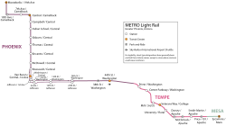
METRO System Diagram Legend
Min Station In Phoenix: 
Metrocenter  Planned, 2026
Dunlap Avenue Planned, 2023Northern Avenue Planned, 2023 Glendale Avenue Planned, 2023 
0 Christown / Bethany Home 
("19th Avenue & Montebello") On Camelback Road: 
2 19th Avenue 5 Melrose District / 7th Avenue 
7 Uptown Phoenix On Central Avenue: 9 Central High / Campbell 11 Indian School 13 Park Central / Osborn 15 Thomas Road 17 Heard Museum / Encanto 19 Cultural District / McDowell 
 Interstate 10
21 Roosevelt Arts District 23 ASU Downtown Campus On Central Avenue: 25 City Hall ("Central/Washington;First/Jefferson") On Jefferson Street (eastbound) and Washington Street (westbound): 27 Convention Center (3rd Street) 30 Eastlake Park (12th Street)  Interstate 10
34 24th Street On Washington Street: 38 Gateway Community College 
Sky Harbor Airport Sky Train (under construction) 


40 Airport / 44th Street 


Operations & Maintenance Center  State Route 143
 State Route 202
In Tempe: 44 Priest Drive/Papago Park Center 46 Center Parkway State Route 202
Tempe Town Lake 50 Mill Avenue Downtown Tempe 52 Sun Devil Stadium ("Veterans Way & College Avenue") 55 University (ASU; Rural Road) On Apache Boulevard: 58 Dorsey Lane 60 McClintock 62 Smith - Martin  State Route 101
64 Loop 101 (Price Freeway) On Main Street in Mesa: 
66 Tri-City / Dobson 
("Sycamore & Main") Alma School Planned, 2016 Country Club Planned, 2016 Center Street Planned, 2016 
Mesa Drive Planned, 2016Stapley Drive Unfunded Gilbert Road UnfundedMetro Light Rail (styled corporately as METRO) is a 32 km (20 mi.) light rail line operating in the U.S. state of Arizona. Part of the Valley Metro public transit system, it serves the cities of Phoenix, Tempe, and Mesa. Construction began in March 2005; operation started December 27, 2008. The line has 2011 estimated daily ridership of 38,700, making it the 13th busiest light rail system in the country.[1]
Contents
Overview
The expected construction cost for the initial 20 miles is $1.4 billion, or $70 million per mile.[2] Metro estimates the train will cost the city $184 million to operate over the next five years with fares covering $44 million of the operation costs and tax subsidies covering the remaining costs.[3]
Trains operate on city streets in a "center reservation," similar to the Red Line of the METRO light rail system in Houston, the surface sections of the Green Line in Boston, and some surface sections of the Muni Metro in San Francisco. Some parts of the line, such as the bridge over Tempe Town Lake (near State Route 202), have no contact with other traffic. The vehicles used are rated for a maximum speed of 55 mph, and have complete the 20 mile route in 65 minutes, including station stops.[4] An equivalent section of the Red Line bus route that the rail line replaced was scheduled for 80 minutes, and was subject to traffic delays during rush hour.[5] The system is powered by an overhead catenary that supplies power at 750V (page 5)
History
Various plans preceded the current implementation of light rail. The Phoenix Street Railway provided streetcar service from 1887 to 1948. Historic vehicles may be seen at the Arizona Street Railway Museum, with Car #116 celebrating her 80th birthday on 25 December 2008, just days before the opening of modern rail service. In 1989, the ValTrans elevated rail proposal,[6] was turned down by voters in a referendum due to cost and feasibility concerns. Other subsequent initiatives during the 1990s failed over similar reasons.
Metro was created by the Transit 2000 Regional Transportation Plan (RTP), which involved a 0.5 per cent sales tax and was approved by voters in Phoenix in 2000. Transit 2000 aimed at improving the local bus service (considered unacceptably inadequate compared to other major US cities) and the formation of bus rapid transit and light rail, among other things, which was seen as a more affordable approach. It used the route placing and color designations from the 1989 plan.
In March 2008, cracks in the system's rails were discovered. The cause of the cracks was determined to be improper use of plasma cutting torches by contractors.[7] The affected track was repaired by May at a cost of $600,000 with still no word on which parties will be held financially responsible.[8] The last of the concrete and rail for the system was installed in the end of April, with CEO declaring the system to be on time and on budget.[9]
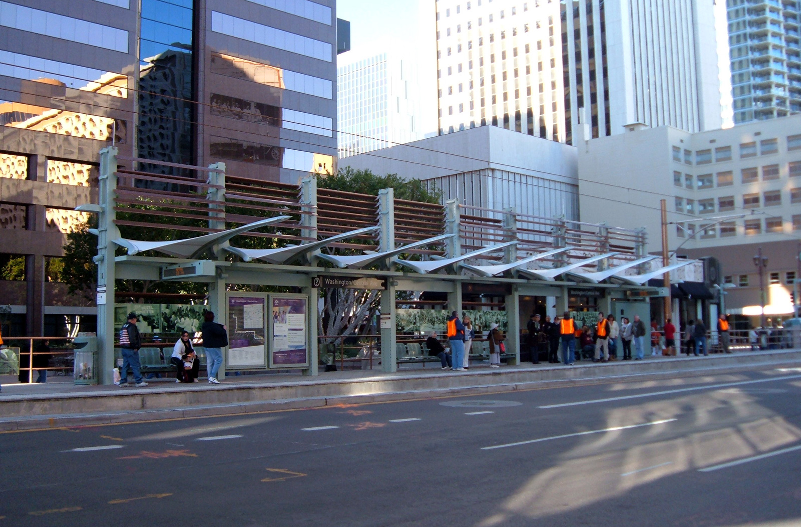
There are 28 stations on the initial twenty-mile starter segment. The line celebrated its grand opening December 27, 2008, with official ribbon-cutting ceremonies and community celebrations spread throughout Phoenix, Tempe, and Mesa. The event was produced by Arizona's Entertainment Solutions, Inc.[10] and was attended by thousands of local residents who waited as long as an hour or more to ride the vehicles.[11][12] The stations have been designed to complement their immediate surroundings.[13] Station platform areas are approximately 16 feet (4.9 m) wide by 300 feet (91 m) long.
As of early March 2010, with ridership far exceeding first-year projections, income was close to meeting Metro's stated goal of 25% farebox recovery. With sales tax and other revenue decreasing, Metro is contemplating a variety of service changes, including shorter hours and slightly longer headways, to close the budget gap.[14]
Valley Metro had its busiest month in September 2011, with a weekday ridership of 47,818. On the 9th of September, 2011, they saw 60,437 board the light rail thanks to fans attending games to see the Arizona State University Sun Devils and the Arizona Diamondbacks.[15]
Fares
Metro Light Rail uses a proof-of-payment system. Tickets can be purchased at ticket vending machines at the entrance to all stations and must be validated before boarding the train. Effective July 1, 2009, the fares are as follows:
- One-Ride Ticket - $1.75
- All-Day Pass - $3.50 (purchased at retail outlet or ticket vending machine)
- All-Day Pass - $5.25 (purchased on board a bus)
Children younger than 5 years of age ride free. Weekly and monthly passes are also available in addition to the fares listed above.[16]
Future extensions and improvements
 Photograph of the Downtown Phoenix (or Central at Washington) Station of Metro Light Rail.
The Valley Metro Rail Northwest Extension is one of the first extensions planned. Engineering has already begun on this 4-mile (6.4 km) route from the current terminus at Bethany Home Road (METRO calls the station, "Montebello Avenue and 19th Avenue") north on 19th Avenue to Dunlap Road, and eventually west to Metrocenter Mall. Utility relocation, right-of-way acquisition, and construction will be from Spring 2009-2011. The project should be ready by late 2012.[not in citation given][17]
 Map of Metro Light Rail system, showing starter line and future expansion corridors.
Proposed commuter rail
The Maricopa Association of Governments (MAG) and the Arizona Department of Transportation are studying suburban commuter rail as a complement to light rail.[18] The MAG Commuter Rail Strategic Plan was released in March 2008.[19][20] In April 2008, a coalition of Arizona business and political leaders, including Governor Janet Napolitano, proposed a $42 billion state transit plan which would include commuter rail.[21] Commuter rail generally uses upgraded existing freight rail lines, with stations every three to five miles (8 km). In Phoenix, as in other areas that have implemented commuter rail, track speeds would be increased, signals updated, and additional sidings and double-track added. Proposals for constructing entirely new rail rights-of-way in the middle of urban highways have largely been eliminated due to their expense and their location far beyond walking distance from downtowns and activity centers.
Contemporary discussion of commuter rail in Phoenix began with the "Hattie B." flood relief train of 1980,[22][23] and was first widely promoted in 1991 by the Arizona Rail Passenger Association.[24]
Daily rail service had existed until the 1960s between Phoenix, Glendale, and Wickenburg as well as Tempe and Mesa. A single short commuter rail line was also part of the ValTrans proposal.
See also
- PHX Sky Train
- List of tram and light-rail transit systems
- List of rail transit systems in the United States
- Light rail in North America
References
- ^ a b American Public Transportation Association, [1], Second Quarter 2011.
- ^ "FAQs and Fast Facts". - ValleyMetro.org. - (Adobe Acrobat *.PDF document).
- ^ http://www.azcentral.com/news/articles/2008/12/09/20081209lrail-money1209.html
- ^ ValleyMetro.org online schedule
- ^ R-route. - ValleyMetro.org Glendale at 19th Ave. is near the Christown Spectrum Mall, the rail's starting point and Main at Dobson is very close to Sycamore. Bus schedule allots 1 hour 20 minutes travel at rush hour
- ^ Phoenix Transit Elections. - Arizona Rail Passenger Association.
- ^ Light-rail cracks: Who is at fault?. - Arizona Republic. - AZCentral.com.
- ^ "30 light-rail sections fixed at cost of $600K". - Arizona Republic. - AZCentral.com. - May 16, 2008.
- ^ "Light-rail construction: The end is near?". - Arizona Republic. - AZCentral.com. - April 29, 2008.
- ^ "METRO Light Rail Grand Opening". - Entertainment Solutions, Inc.
- ^ "Lightrail ON". - Arizona Republic. - AZCentral.com. - December 27, 2008.
- ^ "Phoenix Light Rail Grand Opening 12/27/08 08:00 AM". Valley Metro (Phoenix). http://www.valleymetro.org/bus/rider_alerts/index.htm?alert=205. Retrieved 2008-12-25.
- ^ "Light Rail Station Design". Valley Metro (Phoenix). http://www.valleymetro.org/METRO_light_rail/How_to_Ride/Stations/index.htm. Retrieved 2008-02-20.
- ^ http://www.azfamily.com/news/local/Public-to-weigh-in-on-possible-Light-Rail-cuts-85948422.html
- ^ http://www.valleymetro.org/pressreleases/detail/metro_ridership_peaks_in_september/
- ^ Valley Metro - Fares & Passes - Rates & Options Retrieved 2009-10-06
- ^ Northwest. - ValleyMetro.org
- ^ "All aboard for centennial". Arizona Republic. 2007-02-11. http://www.azcentral.com/arizonarepublic/opinions/articles/0211sun1-11.html. Retrieved 2008-02-20.
- ^ MAG Commuter Rail Strategic Plan. - Maricopa Association of Governments.
- ^ Creno, Glen (2008-02-29). "Phoenix, AZ: MAG Commuter Rail Study draft released". Arizona Republic. http://www.trainnet.org/cgi-bin/dcforum/dcboard.cgi?az=read_count&om=141&forum=DCForumID24. Retrieved 2008-04-09.
- ^ Creno, Glen; Matthew Benson (2008-04-08). "$42 billion proposed for state transit plan". Arizona Republic. http://www.azcentral.com/news/election/azelections/articles/2008/04/08/20080408transit0408.html. Retrieved 2008-04-09.
- ^ Niner, Verne; William A. Ordway (1980-06-20). "“Hattie B” Commuter Train Helps 1980 Flood Situation". Arizona Rail Passenger Association. http://www.azrail.org/1980/195/. Retrieved 2008-02-20.
- ^ "Phoenix commuters loved the Hattie B., now it's time to consider more rail options". Phoenix Business Journal. 2005-12-30. http://phoenix.bizjournals.com/phoenix/stories/2006/01/02/editorial2.html. Retrieved 2008-02-20.
- ^ Regional Rail. - Arizona Rail Passenger Association.
External links
- Metro Light Rail official website
- Article on Valley Metro Rail and preemptive urban revitalization
- Article on commuter rail (Phoenix area) and regional rail (Phoenix-Tucson) proposals
- Slideshow of photos on light rail construction and progress -- from azcentral.com
Currently operating light rail and streetcar systems in the United States ArkansasArizonaCaliforniaMUNI: Cable Car, F Market & Wharves, and Metro lines · Metro Rail: Blue Line, Green Line and Gold Line · Sacramento RT · San Diego Trolley · Sprinter · Santa Clara VTA · Waterfront Red CarColoradoFloridaGeorgiaRiver Street StreetcarLouisianaMassachusettsMarylandMinnesotaMissouri / IllinoisNew JerseyNew YorkNorth CarolinaOhioOregonPennsylvaniaPittsburgh Light Rail · SEPTA Routes 15, 101, 102, and Subway–Surface LinesTennesseeTexasUtahVirginiaWashingtonWisconsinCategories:- Proposed public transportation in the United States
- Valley Metro Rail
- Valley Metro (Phoenix)
- Light rail in Arizona
- Arizona railroads
- Passenger rail transportation in Arizona
- Transportation in Phoenix, Arizona
- Railway lines opened in 2008


Wikimedia Foundation. 2010.