- McClintock Drive and Apache Boulevard (METRO Light Rail station)
-
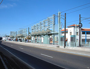
McClintock Station during the grand opening, December 27, 2008Station statistics Address Apache Blvd. at McClintock Dr., Tempe AZ Lines METRO Light Rail Parking 300 spaces [1] Bicycle facilities Parking on south side of Apache Boulevard in front of Grigio Metro apartment complex Other information Opened 2008-12-27 Accessible 
Owned by Valley Metro (Phoenix) Services Preceding station Valley Metro Following station Metro Light Rail Smith Road and Martin Road and Apache BoulevardMcClintock Drive and Apache Boulevard is a station on the METRO light rail line in Tempe, Arizona, USA. A park and ride facility is in the garage attached to apartment complex on southeast corner.
Contents
Notable places nearby
- Grigio Metro apartment complex, from Gray Development.
Ridership
Weekday Rail Passengers[2] Year In Out Average Daily In Average Daily Out 2009 278,721 263,577 1,097 1,038 2010 347,264 300,838 1,373 1,189 Bus connections
- 40, 81 [3]
References
- ^ Frequently Asked Questions
- ^ "2010 Ridership by Station". 1-4-2011. http://www.valleymetro.org/images/uploads/lightrail_publications/METRO-Weekday-Rail-Passengers-by-Station-2010.pdf. Retrieved 2011-09-28.
- ^ "Valley Metro Bus Book Online". 2008-07-28. http://www.valleymetro.org/Bus/Bus_Book_Online/. Retrieved 2008-09-01.
External links
Phoenix Light Rail stations Beginning in Uptown Phoenix Montebello Avenue (Bethany Home Road) and 19th Avenue (Christown) (terminus) - 19th Avenue and Camelback Road - 7th Avenue and Camelback Road (Melrose) - Central Avenue and Camelback Road (Uptown)Entering Midtown Phoenix Campbell Avenue and Central Avenue (Central High) - Indian School Road and Central Avenue - Osborn Road and Central Avenue (Park Central) - Thomas Road and Central Avenue (Midtown) - Encanto Boulevard and Central Avenue (Heard Museum) - McDowell Road and Central Avenue (Library; Cultural District)Entering Downtown Phoenix Roosevelt Street and Central Avenue (Cathedral; Arts District) - Van Buren Street and Central Avenue and Van Buren Street and 1st Avenue (Central Station) - Washington Street and Central Avenue and Jefferson Street and 1st Avenue (City Hall) - 3rd Street and Washington Street and 3rd Street and Jefferson Street (Convention Center)Washington Street Corridor 12th Street and Washington Street and 12th Street and Jefferson Street (Eastlake Park) - 24th Street and Washington Street and 24th Street and Jefferson Street (Hollywood Heights) - 38th Street and Washington Street (GateWay Community College) - 44th Street and Washington Street (Sky Harbor Airport) - Priest Drive and Washington Street (Papago Park) - Center Parkway and Washington StreetCrossing the Tempe Town Lake Bridge and entering Tempe Mill Avenue and 3rd Street (Downtown Tempe) - Veterans Way and College Avenue (Sun Devil Stadium) - University Drive and Rural Road (ASU) - Dorsey Lane and Apache Boulevard - McClintock Drive and Apache Boulevard - Smith Road and Martin Road and Apache Boulevard - Price Road (Route 101) and Apache BoulevardEntering Mesa Sycamore Drive (Dobson Road) and Main Street (terminus)Official route and station location map from Valley Metro
Coordinates: 33°24′53.25″N 111°54′30″W / 33.4147917°N 111.90833°WCategories:- Valley Metro Rail stations
- Railway stations opened in 2008

Wikimedia Foundation. 2010.