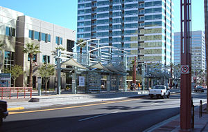
- Osborn Road and Central Avenue (METRO Light Rail station)
-
Osborn Road and Central Avenue (Park Central) 
Park Central Station on December 28, 2008Station statistics Address Central Avenue and Osborn Road
Phoenix, AZLines METRO Light Rail Other information Opened 27 December 2008 Accessible 
Owned by Valley Metro (Phoenix) Services Preceding station Valley Metro Following station Indian School Road and Central AvenueMetro Light Rail Thomas Road and Central AvenueOsborn Road and Central Avenue (also known as Park Central) is a station on METRO Light Rail in Phoenix, Arizona, USA. It is the seventh stop southbound and the twenty-second stop northbound on the initial 20 mile starter line.
Contents
Nearby places
- Phoenix Central Neighborhood
- Phoenix Financial Center
- Park Central Mall
- St. Joseph's Hospital and Medical Center
- Phoenix Corporate Center
Ridership
Weekday Rail Passengers Year In Out Average Daily In Average Daily Out 2009 199,75 188,723 786 743 2010 210,59 210,606 832 832 Bus connections
- 0, 512, 570, 582, 590 [1]
References
- ^ "Valley Metro Bus Book Online". 2008-07-28. http://www.valleymetro.org/Bus/Bus_Book_Online/. Retrieved 2008-09-01.
External links
Phoenix Light Rail stations Beginning in Uptown Phoenix Montebello Avenue (Bethany Home Road) and 19th Avenue (Christown) (terminus) - 19th Avenue and Camelback Road - 7th Avenue and Camelback Road (Melrose) - Central Avenue and Camelback Road (Uptown)Entering Midtown Phoenix Campbell Avenue and Central Avenue (Central High) - Indian School Road and Central Avenue - Osborn Road and Central Avenue (Park Central) - Thomas Road and Central Avenue (Midtown) - Encanto Boulevard and Central Avenue (Heard Museum) - McDowell Road and Central Avenue (Library; Cultural District)Entering Downtown Phoenix Roosevelt Street and Central Avenue (Cathedral; Arts District) - Van Buren Street and Central Avenue and Van Buren Street and 1st Avenue (Central Station) - Washington Street and Central Avenue and Jefferson Street and 1st Avenue (City Hall) - 3rd Street and Washington Street and 3rd Street and Jefferson Street (Convention Center)Washington Street Corridor 12th Street and Washington Street and 12th Street and Jefferson Street (Eastlake Park) - 24th Street and Washington Street and 24th Street and Jefferson Street (Hollywood Heights) - 38th Street and Washington Street (GateWay Community College) - 44th Street and Washington Street (Sky Harbor Airport) - Priest Drive and Washington Street (Papago Park) - Center Parkway and Washington StreetCrossing the Tempe Town Lake Bridge and entering Tempe Mill Avenue and 3rd Street (Downtown Tempe) - Veterans Way and College Avenue (Sun Devil Stadium) - University Drive and Rural Road (ASU) - Dorsey Lane and Apache Boulevard - McClintock Drive and Apache Boulevard - Smith Road and Martin Road and Apache Boulevard - Price Road (Route 101) and Apache BoulevardEntering Mesa Sycamore Drive (Dobson Road) and Main Street (terminus)Official route and station location map from Valley Metro
Coordinates: 33°29′12″N 112°4′25.50″W / 33.48667°N 112.07375°WCategories:- Valley Metro Rail stations
- Railway stations opened in 2008
- Buildings and structures in Phoenix, Arizona
- Transportation in Maricopa County, Arizona
- Western United States railway station stubs
- Arizona building and structure stubs
Wikimedia Foundation. 2010.
