- Merrickville–Wolford
-
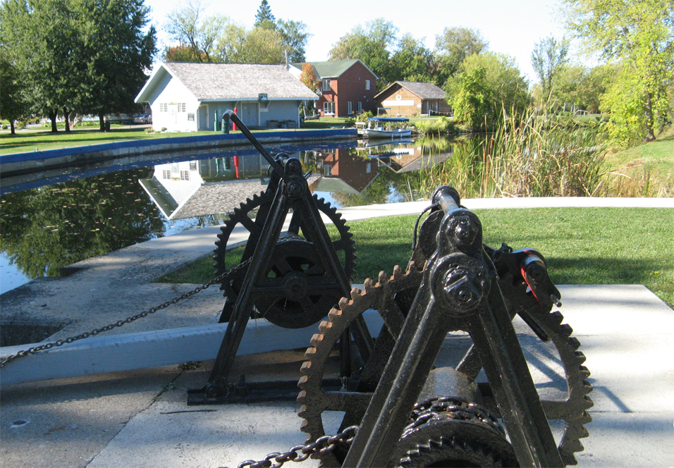
Merrickville-Wolford — Village — Rideau Canal locks in Merrickville
Motto: Jewel of the Rideau. 
 Merrickville-Wolford
Coordinates: 44°55′N 75°50′W / 44.917°N 75.833°W Country  Canada
Province  Ontario
County Leeds and Grenville Settled 1794 Incorporated January 1, 1998 (Merrickville-Wolford) Government - Mayor J. Douglas Struthers - Governing Body Merrickville Village Council - Federal riding Leeds–Grenville - Prov. riding Leeds–Grenville Area[1] - Land 213.77 km2 (82.5 sq mi) Population (2006)[1] - Total 2,867 - Density 13.4/km2 (34.7/sq mi) Time zone Eastern (EST) (UTC-5) - Summer (DST) Eastern (EDT) (UTC-4) Area code(s) 613 Website village.merrickville-wolford.on.ca Merrickville–Wolford is a village-status municipality in Eastern Ontario, Canada, located in Leeds and Grenville United Counties. It spans both shores of the Rideau River.
The current municipality was incorporated on January 1, 1998 by amalgamating the former village of Merrickville with the former township of Wolford.
The Rideau Canal locks at Merrickville with three locks have a total lift of twenty five feet. On the south side of the locks there is the old blockhouse, which has been restored by Parks Canada as a tourist site and museum operated by the Merrickville and District Historical Society.
In the last two decades, the region has seen a boom in the local economy mostly related to increased tourism. It is famous for its local crafts people and artists.
Contents
History
William Merrick founded the village of Merrickville in 1794. Attracted to the site by waterpower, he constructed a dam across the river and then built grist, saw and carding mills. It was not long before a community sprang up around the milling activity. In 1821, Merrick built a stone house overlooking his mills.
When the construction crews arrived in 1827 to build the Rideau Canal, the village of Merrick's Mills, as it was then known, was a thriving community of about 300. A plaque was erected by the Merrickville and District Historical Society in remembrance of an unknown number of persons who were buried in the McGuigan Cemetery between the years 1800 and 1900; Many died of pestilence, principally malaria, during the construction of the Rideau Canal.
Unlike most of the pre-canal sites, Merrick's Mills was not destroyed by canal construction. After the canal was completed, the excess water once again turned the wheels of the mills and the improved transportation system caused a surge in commercial activity in the village. By 1851, Merrick's Mills was an impressive industrial centre.
Merrick's Mills continued to thrive into the mid-1860s. The end of the community's industrial growth is closely related to the decline of the commercial phase of the Rideau canal. The rise of the nearby town of Smiths Falls as a major railway hub displaced Merrick's Mills as an industrial leader in the region. Despite the decline, some industry continued in the community. In 1915 a power company was formed at Merrickville to provide electricity for the mills and a foundry, and the woolen mill continued to function until 1954.
Communities
In addition to Merrickville, the village comprises the smaller communities of Carleys Corners, Eastons Corners, Hemlock Corners, Jasper, Snowdons Corners, Wolford Centre, Wolford Chapel and Yule.
Demographics
Population trend:[2]
- Population in 2006: 2867 (2001 to 2006 population change: 2.0 %)
- Population in 2001: 2812
- Population in 1996:
- Merrickville Village: 1027
- Wolford Township: 1603
- Population in 1991:
- Merrickville Village: 989
- Wolford Township: 1438
Private dwellings occupied by usual residents: 1115 (total dwellings: 1195)
Mother tongue:[1]
- English as first language: 92.4 %
- French as first language: 3.9 %
- English and French as first language: 0 %
- Other as first language: 3.7 %
Attractions
Merrickville was acknowledged as Canada's Most Beautiful Village by Communities in Bloom in 1998, as its charming streets are lined with heritage architecture, artists' studios, specialty boutiques and restaurants. There is a thriving artisan community with more than 30 artists in the area.
Merrickville is considered by many historians to be Canada's best preserved and restored 19th century village,[citation needed] with more than 100 historic and heritage properties. One of the oldest settlements along the Rideau canal, a major feature in the village is the set of three locks on the Rideau Canal. You will find these adjacent to the Blockhouse, built in 1832 to guard the locks against American attacks.
The Blockhouse, a National Historic Site of Canada,[3][4] was built by Lt. Col. John By as part of a chain of four blockhouses for the defense of the Rideau Canal. The Blockhouse Museum is open during peak summer season. Near the locks is the Industrial Heritage Complex Museum, the site of the original mills.
Merrickville artists include Pat Hardie - photographer & textile artist, Holly Dean - mixed media artist, Barbara Gibson-Dutton - watercolourist & china painter, Laura Starkey - acrylic artist, Martin Green - artist in various media, Pieter Doef - sculptor, Robin Baker - mixed media artist & instructor, Sue Boswell - potter, Jeannette Froese LeBlanc - potter & jewellery, Claudette Hart - the 'she's outta her gourd' lady, potter, Kevin Gray Glassblowing whose gallery is open every day for demonstrations, David Paterson Handblown Glass, whose gallery is open daily, glassblower Bronwyn McNight at Kiss My Glass, and Angelina Wrona - a lowbrow pop surrealist painter.
The Merrickville Artists Guild Studio Tour, the last weekend of September and first weekend in October, is Eastern Ontario's original artists' tour,[citation needed] and features the work of over 30 artists each year.
Gardening enthusiasts can stroll through the Rideau Woodland Ramble, declared one of Canada's Top Garden Destinations[citation needed] with a huge range of rare and exotic plants, trees and shrubs located just south of the village of Burritt's Rapids.
Every summer there is the Merrickville Fair which birngs a Midway, Demolition Derby, FunLight Laser Tag, and other attactions to the town.
As Merrickville is much more than just a day trip, there are a number of delightful B&Bs, as well as an Inn to overnight at. Restaurants range from pubs, cafés and diners to fine gourmet meals featuring local specialties, family Italian cooking and home made gelato and ice cream.
Merrickville is also home to the 1st Merrickville Scout Group. Founded in 1908, and still thriving with over 70 youth involved, it is the oldest scout group in North America.[citation needed]
References
- ^ a b c Statistics Canada 2006 Census - Merrickville-Wolford community profile
- ^ Statistics Canada: 1996, 2001, 2006 census
- ^ Merrickville Blockhouse, Directory of Designations of National Historic Significance of Canada
- ^ Merrickville Blockhouse. Canadian Register of Historic Places.
External links
- Village of Merrickville-Wolford
- Merrickville and District Historical Society
- Merrickville Chamber of Commerce

Smiths Falls
Rideau LakesMontague Ottawa Elizabethtown-Kitley 
North Grenville  Merrickville-Wolford

Augusta Categories:- Municipalities in Leeds and Grenville United Counties, Ontario
- Villages in Ontario

Wikimedia Foundation. 2010.