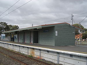
- Merlynston railway station
-
Merlynston 

Station information Code MYN Distance from
Flinders Street13.7 km Operator Metro Trains Melbourne Lines Upfield # Platforms 2 # Tracks 2 Status Unmanned station Metlink profile Link Melway map Link Google map Link Metcard / Myki Zone 1+2 overlap Merlynston is a railway station in Melbourne, Victoria, Australia. It is located on the Upfield railway line in the suburb of Coburg North.
It is 13.7 km from Flinders Street Station, and is located in the overlap between Metcard ticketing Zone 1 & Zone 2.
Contents
Facilities
The station is unstaffed, except for a period of around two hours in the morning peak on weekdays. It is located on an island platform with a small pebblemix station building at the Upfield end of the station. It has a Safety Zone on both platforms, in addition to Metcard ticketing equipment located at the entrance, adjacent to the disused booking window. There are newspaper dispensers for both The Herald Sun and The Age next to the ticket machine.
The station also has decent sized car parking facilities and connecting bus services, and therefore is reasonably well patronised. It is located very close to Sydney Road, from which Route 530 and 531 depart. The 534 bus (to Glenroy station on the Craigieburn line) departs from the east of the station, alternately from Lorenson Avenue and Merlyn Street.
There is a small shopping strip to the west side of the station and also to the east in Sydney Rd, being located in a primarily residential area. Commuters often drive to Merlynston from further down the line to take advantage of the cheaper Zone 1 Metcard fares. The station has unusual handrails all along the island platform, and patrons must use a pedestrian crossing to access the platforms.
A small semi-enclosed waiting room is located at the southern end of the building. There was formerly a level crossing located at Shorts Road, south of Merlynston, which was closed in the late 1990s, and made into a dead-end street on either side of the railway line. Until duplication to Gowrie in 1998, the railway line north of the station had only a single track (except for the island platform at Gowrie, which had two platforms but one platform was a dead-end platform, meaning trains couldn't cross at Gowrie, so trains had to cross by Merlynston).
Platforms and services
Platform 1:
- Upfield line - all stations services to Flinders Street
Platform 2:
- Upfield line - all stations services to Upfield
Bus services
- 530 Coburg – Campbellfield via Merlynston RS, Fawkner RS, Gowrie RS (every day). Operated by Broadmeadows Bus Service.
- 531 Upfield – North Coburg via Fawkner RS, Gowrie RS (Monday to Friday). Operated by Broadmeadows Bus Service.
- 534 Glenroy – Coburg via Merlynston RS, Batman RS (Monday to Saturday). Operated by Dyson's Bus Services.
History
Merlynston station opened on 8 October 1889 as North Coburg. It closed in 1903, and reopened in 1914. It was renamed Merlynston in 1922.[1] Boom barriers were provided at Boundary Road (down end of the station) in 1984.[2]
Gallery
References
Station Navigation Upfield line ← Previous Station Batman | Fawkner Next Station → Entire network Melbourne's public transport - Metlink Modes and network Ticketing Metropolitan rail operators Metro Trains Melbourne (heavy rail) • KDR Melbourne - Yarra Trams (tram/light rail)Regional rail operators V/Line (heavy rail)Metropolitan and regional bus operators Broadmeadows Bus Service • Cardinia Transit • Cranbourne Transit • Driver Bus Lines • Dyson's Bus Services • Eastrans • East West Bus Company • Grenda's • Hope Street Bus Line • Invicta Bus Services • Ivanhoe Bus Company • Kastoria Bus Lines • Martyrs Bus Service • Melbourne Bus Link • McKenzie's • Moonee Valley • Moorabbin Transit • Moreland Buslines • NationalBus • Panorama Coaches • Peninsula Bus Lines • Portsea • Reservoir • Ryan Brothers Bus Service • Sita Buslines • Skybus Super Shuttle • Sunbury Bus Service • Tullamarine Bus Lines • US Bus Lines • Ventura Bus Lines • WestransPlanned infrastructure Melbourne Metro • Regional Rail Link • Proposed Rail ExtensionsAuthorities Coordinates: 37°43′15″S 144°57′41″E / 37.7209°S 144.9613°E
Categories:- Railway stations in Melbourne
- Railway stations opened in 1889
Wikimedia Foundation. 2010.
