- Maroochydore
-
For other uses, see Maroochydore (disambiguation).
Maroochydore
Sunshine Coast, Queensland
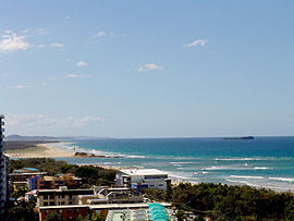
View of MaroochydorePopulation: 49,743 (2006) Area: 55.5 km² (21.4 sq mi) Location: 104 km (65 mi) from Brisbane LGA: Sunshine Coast Region State District: Maroochydore, Buderim, Kawana, Nicklin Federal Division: Fairfax, Fisher Mean max temp Mean min temp Annual rainfall 25.1 °C
77 °F15.8 °C
60 °F1,310.6 mm
51.6 inMaroochydore is an urban centre on the Sunshine Coast, Queensland, Australia.
Maroochydore is a major commercial area of the Sunshine Coast with most shopping precincts located in the central business district. It is home to the Sunshine Plaza[1] shopping centre and the Sunshine Coast's major bus interchange for TransLink services on Sunshine Coast. Maroochydore is also a venue of major surf sport carnivals, and is a popular holiday point from which to travel the rest of Queensland.
The name Maroochydore comes from the Yuggera language word 'Muru-kutchi', meaning red-bill: the name of the black swan, commonly seen in the area.
Maroochydore is the sixth town mentioned in the original (Australian) version of the song "I've Been Everywhere".
Contents
Geography
Maroochydore is not strictly defined, but the boundary used by Sunshine Coast Regional Council (formerly the Maroochy Shire) includes a region from the southern boundary of Sunshine Coast Airport to the Mooloolah River at Mooloolaba and Kawana Way. This corresponds to the historic Australian Bureau of Statistics urban centres of Maroochydore–Mooloolaba and Mudjimba. The central business district (CBD) for the area is located on Horton Parade, Maroochydore.
The Maroochydore urban centre consists of the following suburbs:
- Alexandra Headland
- Bli Bli (part)
- Buderim (section within about 1 km of Sunshine Motorway)
- Kuluin
- Maroochydore
- Mooloolaba
- Mountain Creek
- Mudjimba
- Pacific Paradise
- Twin Waters
The current ASGC, applicable to the 2001 and 2006 censuses, has placed all of Buderim and Mountain Creek under the Buderim SLA.
Transport
Maroochydore's suburbs are served by Sunbus Sunshine Coast, who operate a bus interchange at Sunshine Plaza in the CBD. Various bus routes connect Maroochydore to Buderim, Coolum, Kawana, Caloundra, Nambour and Noosa.[2]
Nambour Station on the Nambour / Gympie North Line has regular services to Brisbane, operated by QR Citytrain. There are also coach services from Sunshine Plaza to Brisbane Airport.[3]
Sunshine Coast Airport is located just north of the urban centre in Marcoola. It offers domestic flights to state capital cities around Australia.
Population
Census populations for the Maroochydore urban centre have been recorded since 1933, and for Mudjimba since 1981.
Year Population
(Total)Population
(Maroochydore)Population
(Mudjimba)1933 630 630 1947 2,164 2,164 1954 2,655 2,655 1961 3,068 3,068 1966 4,106 4,106 1971 6,374 6,374 1976 10,283 10,283 1981 18,444 17,460 984 1986 22,099 20,635 1,464 1991 30,856 28,509 2,347 1996 40,766 36,406 4,360 2001 47,951 39,458 8,493 2006 49,743 39,123 10,620 Education
The main state secondary school in the town is Maroochydore State High School (1964). Other schools in the area include:
- Bli Bli State School (1901)
- Kuluin State School (1987)
- Maroochydore State School (1921)
- Mooloolaba State School (1933)
- Mountain Creek State School (1994)
- Mountain Creek State High School (1995)
- Pacific Paradise State School (1992)
- Immanuel Lutheran College (1982)
- Stella Maris Catholic Primary School (1980)
See also
References
- ^ http://www.sunshineplaza.com/
- ^ Translink Queensland. "All bus timetables". http://jp.translink.com.au/travel-information/services-and-timetables/buses/all-bus-timetables. Retrieved 21 June 2011.
- ^ Sunair. "Brisbane Airport Transit Stop". http://www.sunair.com.au/brisbane-airport-transit-stop.html. Retrieved 21 June 2011.
External links
Coordinates: 26°39′S 153°06′E / 26.65°S 153.1°E
Categories:- Towns in Queensland
- Australian Aboriginal placenames
- Maroochydore
- Sunshine Coast, Queensland geography stubs
Wikimedia Foundation. 2010.
