- Maravatío
-
Maravatío — Municipality — 
SealLocation of Maravatío
 Maravatío
Coordinates: 19°53′51.33″N 100°26′59.99″W / 19.8975917°N 100.4499972°WCoordinates: 19°53′51.33″N 100°26′59.99″W / 19.8975917°N 100.4499972°W Country  Mexico
State Michoacán Municipal seat Maravatío de Ocampo Government – Municipal president Octavio Vergara Mora (PAN) Area – Total 691.55 km2 (267 sq mi) Elevation 2,036 m (6,680 ft) Population (2005) – Total 70,170 – Density 101.5/km2 (262.8/sq mi) Time zone CST (UTC-6) – Summer (DST) CDT (UTC-5) Municipality created Website [1] Maravatío is a municipality in the Mexican state of Michoacán, representing 1.17% of its land area, or 691.55 km2.
Contents
Etymology
The modern word Maravatío comes from the P'urhépecha word Marhabatio, meaning a precious place or thing.
Geography
Neighboring locations include Guanajuato to the north; Contepec and Tlalpujahua to the east; Senguio, Irimbo, and Ciudad Hidalgo to the south; and Zinapécuaro to the west.
Economy
The economy of Maravatío is primarily agricultural in nature, focusing on the production of strawberries, corn, beans, potatoes, wheat, and tomatoes. The municipality also has a herd of cattle with some economic importance, industries focused on the fabrication of ornamental ironwork, as well as business sectors.
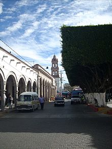 Maravatío city center, with the tower of the Parish Church in the distance.
Tourist attractions
Some of the principal places of interest to tourists in the municipality are the following:
- The Parish Church of San Juan Bautista
- Hacienda de Pomoca (the place where Melchor Ocampo lived)
- El Teatro Morelos (The Morelos Theater)
- El Mirador
The city contains the parochial temple of San Juan Bautista, built in the baroque style in the 16th century, as well as the chapel of the Immaculate Conception, in the mudéjar style; the chapel of the Lord of the Column; the Chapel of Saint Michael Archangel, in San Miguel Curahuango; the temple of Saint Mary, in Ziritzícuaro; and the temple of Uripitío.
Also of interest are the former haciendas of Apeo that were the property of Don Mateo Echaíz de Santa Elena in 1857; the house where Don Miguel Hidalgo stayed, near Independence Gate; the railway station, at which trains first arrived in 1883; and the Morelos Theater, constructed in the Porfirio Díaz era, which was inaugurated with a performance by the soprano Ángela Peralta.
Maravatío is a good base for visiting Monarch butterfly sanctuaries between October and March, and there are many hot springs near the city suitable for bathing.
Politics
Executive power in the municipality is vested in the Presidente Municipal or Municipal President. The following table lists Maravatío's past executives:
Term Municipal President Political party 1972 Guillermo Calderón Díaz Institutional Revolutionary Party 1972-1974 Salvador Olvera Quintero Institutional Revolutionary Party 1975-1977 Moisés Aguilar Monroy Institutional Revolutionary Party 1978-1980 José Coronel Zamudio Institutional Revolutionary Party 1981-1982 Florencio Alcantar Mejía Institutional Revolutionary Party 1983 Cuauhtémoc Núñez Institutional Revolutionary Party 1984-1986 Antonio Cruz Melo Institutional Revolutionary Party 1987-1989 Carlos Torroella Institutional Revolutionary Party 1990-1992 Cresenciano Hernández Party of the Democratic Revolution 1993-1995 Raúl Fierros Fierros Institutional Revolutionary Party 1996-1998 Mario Cruz Andrade Party of the Democratic Revolution 1999-2001 José Jaime Hinojosa Campa Party of the Democratic Revolution 2002-2004 Ignacio Montoya Marin Party of the Democratic Revolution 2005-2007 José Jaime Hinojosa Campa Party of the Democratic Revolution 2008-present Octavio Vergara Mora National Action Party Famous people
- Cayetano Gómez de Soria y Piñón (1791-?). Entrepreneur and land owner. A person of Spanish ancestry born in Mexico with humble beginnings, who began buying property at an early age until becoming one of the most important owners of haciendas in Michoacán.
References
External links
- Website of Maravatío, Michoacán nuestromaravatio.com.mx
- Website oficial, turístico y local
- Página oficial del Municipio de Maravatio de Ocampo
- Enciclopedia de los Municipios de México
- Universidad Michoacana
- arxfest[2],[3]
- maravatio.pueblox.com
Municipalities
and
(municipal seats)Acuitzio (Acuitzio del Canje) · Aguililla (Aguililla) · Álvaro Obregón (Álvaro Obregón) · Angamacutiro (Angamacutiro de la Unión) · Angangueo · Apatzingán (Apatzingán de la Constitución) · Aporo, Michoacán · Aquila (Aquila) · Ario (Ario de Rosales) · Arteaga (Arteaga) · Briseñas (Briseñas de Matamoros) · Buenavista (Buenavista Tomatlán) · Caracuaro (Caracuaro de Morelos) · Charapan (Charapan) · Charo (Charo) · Chavinda (Chavinda) · Cherán (Cherán) · Chilchota (Chilchota) · Chinicuila (Villa Victoria) · Chucándiro (Chucándiro) · Churintzio (Churintzio) · Churumuco (Churumuco de Morelos) · Ciudad Hidalgo · Coahuayana (Coahuayana de Hidalgo) · Coalcomán de Vázquez Pallares (Coalcomán de Vázquez Pallares) · Coeneo (Coeneo de la Libertad) · Cojumatlán de Régules (Cojumatlán de Régules) · Contepec (Contepec) · Copándaro (Copándaro de Galeana) · Cotija (Cotija de la Paz) · Cuitzeo (Cuitzeo del Porvenir) · Ecuandureo (Ecuandureo) · Epitácio Huerta (Epitácio Huerta) · Erongaricuaro (Erongaricuaro) · Gabriel Zamora (Lombardía) · La Huacana (La Huacana) · Huandacareo (Huandacareo) · Huaniqueo (Huaniqueo de Morales) · Huetamo (Huetamo de Núñez) · Huiramba (Huiramba) · Indaparapeo (Indaparapeo) · Irimbo (Irimbo) · Ixtlán (Ixtlán de los Hervores) · Jacona (Jacona de Plancarte) · Jiménez (Villa Jiménez) · Jiquilpan (Jiquilpan de Juárez) · José Sixto Verduzco (Pastor Ortiz) · Juárez (Benito Juárez) · Jungapeo (Jungapeo de Juárez) · Lagunillas (Lagunillas) · La Piedad (La Piedad) · Lázaro Cárdenas (Lázaro Cárdenas) · Los Reyes (Los Reyes de Salgado) · Madero (Villa Madero) · Maravatío (Maravatío de Ocampo) · Marcos Castellanos (San José de Gracia) · Morelia (Morelia) · Morelos (Villa Morelos) · Múgica (Nueva Italia) · Nahuatzén (Nahuatzén) · Nocupétaro (Nocupétaro de Morelos) · Nuevo Parangaricutiro (Nuevo San Juan Parangaricutiro) · Nuevo Urecho (Nuevo Urecho) · Numarán (Numarán) · Ocampo (Ocampo) · Pajacuarán (Pajacuarán) · Panindicuaro (Panindicuaro) · Paracho (Paracho de Verduzco) · Parácuaro (Parácuaro) · Pátzcuaro · Penjamillo (Penjamillo de Degollado) · Peribán (Peribán de Ramos) · Purépero (Purépero de Echaíz) · Puruándiro (Puruándiro) · Queréndaro (Queréndaro) · Quiroga (Quiroga) · Sahuayo (Sahuayo de Morelos) · San Lucas (San Lucas) · Santa Ana Maya (Santa Ana Maya) · Santa Clara del Cobre · Senguío (Senguío) · Susupuato (Susupuato de Guerrero) · Tacámbaro (Tacámbaro de Codallos) · Tancítaro (Tancítaro) · Tangamandapio (Santiago Tangamandapio) · Tangancícuaro (Tangancícuaro de Arista) · Tanhuato (Tanhuato de Guerrero) · Taretan (Taretan) · Tarímbaro (Tarímbaro) · Tepalcatepec (Tepalcatepec) · Tingambato (Tingambato) · Tingüindín (Tingüindín) · Tiquicheo de Nicolas Romero (Tiquicheo) · Tlalpujahua · Tlazazalca (Tlazazalca) · Tocumbo (Tocumbo) · Tumbiscatío (Tumbiscatío de Ruiz) · Turicato (Turicato) · Tuxpan (Tuxpan) · Tuzantla (Tuzantla) · Tzintzuntzan · Tzitzío (Tzitzío) · Uruapan (Uruapan) · Venustiano Carranza (Venustiano Carranza) · Villamar (Villamar) · Vista Hermosa (Vista Hermosa de Negrete) · Yurécuaro (Yurécuaro) · Zacapu (Zacapu) · Zamora (Zamora de Hidalgo) · Zináparo (Zináparo) · Zinapécuaro (Zinapécuaro de Figueroa) · Ziracuaretiro (Ziracuaretiro) · Zitácuaro (Heroica Zitácuaro)
 Categories:


Wikimedia Foundation. 2010.