- Manada Gap, Pennsylvania
-
Manada Gap — Unincorporated community — Location within the state of Pennsylvania
 Manada Gap
Coordinates: 40°23′49″N 76°42′36″W / 40.39694°N 76.71°WCoordinates: 40°23′49″N 76°42′36″W / 40.39694°N 76.71°W Country United States State Pennsylvania County Dauphin Time zone Eastern (EST) (UTC-5) – Summer (DST) EDT (UTC-4) ZIP codes FIPS code GNIS feature ID Manada Gap is an unincorporated community in Dauphin County, Pennsylvania, United States, in the Harrisburg-Carlisle area, near Fort Indiantown Gap.
Fort Manada
Distant about twelve miles from Fort Hunter is the passage through the Blue Range called Manada Gap, the next station in the chain occupied by the government. As in the case of Fort Hunter, the settlers about Manada Gap had already commenced a place of defense in the latter part of the fall of 1755. In February 1756, Captain Frederick Smith, with his company of provincials, cither completed the fort already commenced or erected a new one. This was called Manada Fort.
It was the ordinary block-house surrounded by a stockade. It stood on what is now the property of William Rhoads, east of the Manada Creek, about midway between it and the road to Jonestown, Pennsylvania and three-quarters of a mile south of the mill in Manada Gap. On the historical map it is located on the wrong side of the stream and rather too close to the mountain. Being of minor importance,or at least so considered, it was used only a couple of years. The exact location of this fort has never before been given.[1]
Notes
Municipalities and communities of Dauphin County, Pennsylvania City 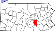
Boroughs Berrysburg | Dauphin | Elizabethville | Gratz | Halifax | Highspire | Hummelstown | Lykens | Middletown | Millersburg | Paxtang | Penbrook | Pillow | Royalton | Steelton | Williamstown
Townships Conewago | Derry | East Hanover | Halifax | Jackson | Jefferson | Londonderry | Lower Paxton | Lower Swatara | Lykens | Middle Paxton | Mifflin | Reed | Rush | South Hanover | Susquehanna | Swatara | Upper Paxton | Washington | Wayne | West Hanover | Wiconisco | Williams
CDPs Unincorporated
communitiesBachmanville | Beaufort Farms | Dietrich | Deodate | Carsonville | Catalina | Ebenezer | Edgemont | Ellendale Forge | Enders | Enterline | Estherton | Fort Hunter | Grantville | Hanoverdale | Hanover Heights | Heckton | Hillside Village | Hockersville | Hoernerstown | Inglenook | Jednota | Killinger | Loyalton | Lucknow | Manada Gap | Manada Hill | Matamoras | Montrose Park | Oakleigh | Oakmont | Oberlin Gardens | Paxtang Manor | Palmdale | Piketown | Powells Valley | Ridgeview | Ritzie Village | Rockville | Sand Beach | Shellsville | Singersville | Swatara | Vaughn | Union Deposit | Waynesville | Windsor Farms
Categories:- Harrisburg metropolitan area
- Unincorporated communities in Dauphin County, Pennsylvania
- Dauphin County, Pennsylvania geography stubs


Wikimedia Foundation. 2010.