- Millersburg, Pennsylvania
-
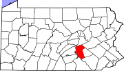
Millersburg, Pennsylvania — Borough — Millersburg, Pennsylvania Coordinates: 40°32′30″N 76°57′26″W / 40.54167°N 76.95722°WCoordinates: 40°32′30″N 76°57′26″W / 40.54167°N 76.95722°W Country United States State Pennsylvania County Dauphin Settled 1807 Incorporated 1850 Government – Type Borough Council – Mayor Richard Ibberson Area – Total 0.8 sq mi (2.1 km2) Elevation 166 ft (51 m) Population (2000) – Total 2,562 – Density 3,290.2/sq mi (1,270.4/km2) Time zone Eastern (EST) (UTC-5) – Summer (DST) EDT (UTC-4) Zip code 17061 Area code(s) 717 Millersburg is a borough in Dauphin County, Pennsylvania, United States. The population was 2,562 at the 2000 census. It is part of the Harrisburg–Carlisle Metropolitan Statistical Area.
Contents
Geography
Millersburg is located on the east bank of the Susquehanna River at 40°32′30″N 76°57′26″W / 40.54167°N 76.95722°W (40.541676, -76.957283).[1] According to the United States Census Bureau, the borough of Millersburg has a total area of 0.8 square miles (2.1 km2), all of it land.
History
Millersburg was founded in 1807 by Daniel Miller, for whom the town was named.
The Millersburg Ferry and Millersburg Passenger Rail Station are listed on the National Register of Historic Places.[2]
Demographics
As of the census[3] of 2000, there were 2,562 people, 1,213 households, and 695 families residing in the borough. The population density was 3,290.2 people per square mile (1,268.2/km²). There were 1,315 housing units at an average density of 1,688.7 per square mile (650.9/km²). The racial makeup of the borough was 98.52% White, 0.23% African American, 0.12% Native American, 0.51% Asian, 0.31% from other races, and 0.31% from two or more races. Hispanic or Latino of any race were 1.09% of the population.
There were 1,213 households out of which 24.4% had children under the age of 18 living with them, 44.0% were married couples living together, 9.3% had a female householder with no husband present, and 42.7% were non-families. 37.8% of all households were made up of individuals and 20.4% had someone living alone who was 65 years of age or older. The average household size was 2.11 and the average family size was 2.78.
In the borough the population was spread out with 20.6% under the age of 18, 9.2% from 18 to 24, 28.4% from 25 to 44, 20.6% from 45 to 64, and 21.2% who were 65 years of age or older. The median age was 39 years. For every 100 females there were 84.8 males. For every 100 females age 18 and over, there were 84.8 males.
The median income for a household in the borough was $34,970, and the median income for a family was $44,327. Males had a median income of $29,625 versus $23,205 for females. The per capita income for the borough was $19,217. About 4.7% of families and 6.8% of the population were below the poverty line, including 5.8% of those under age 18 and 7.8% of those age 65 or over.
Millersburg ferry
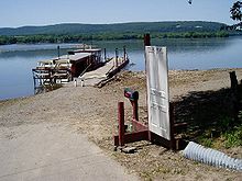
The Millersburg Ferry, the last surviving ferry across the Susquehanna River, operates out of Millersburg, which sits on the east side of the river. According to a sign posted at the ferry dock, a ferry has operated here since 1825. The original ferries were poled across the river. Paddle-wheel boats went into operation in 1873. The current ferries are wooden-stern paddle-wheelers which can carry up to four automobiles. The one-mile crossing goes to a point on the west side of the Susquehanna, in a campground near the point where Pennsylvania State Route 34 meets U.S. Route 11 & U.S. Route 15, and near Liverpool. The ferry boats were officially listed on the National Register of Historic Places in 2006. [4]
Ned Smith Center
Millersburg is the home of the Ned Smith Center for Nature and Art which was opened on October 9, 2004.[5]
References
- ^ "US Gazetteer files: 2010, 2000, and 1990". United States Census Bureau. 2011-02-12. http://www.census.gov/geo/www/gazetteer/gazette.html. Retrieved 2011-04-23.
- ^ "National Register Information System". National Register of Historic Places. National Park Service. 2010-07-09. http://nrhp.focus.nps.gov/natreg/docs/All_Data.html.
- ^ "American FactFinder". United States Census Bureau. http://factfinder.census.gov. Retrieved 2008-01-31.
- ^ Annette Gunyuzlu / Millersburg Ferry Boat Association (2006). "National Register of Historic Places Registration Form: Millersburg Ferry / Kramer-Crow Ferry" (PDF). https://www.dot7.state.pa.us/ce_imagery/phmc_scans/H086655_01H.pdf. Retrieved 2009-07-30.
- ^ Ned Smith Center
External links
Municipalities and communities of Dauphin County, Pennsylvania City Boroughs Berrysburg | Dauphin | Elizabethville | Gratz | Halifax | Highspire | Hummelstown | Lykens | Middletown | Millersburg | Paxtang | Penbrook | Pillow | Royalton | Steelton | Williamstown
Townships Conewago | Derry | East Hanover | Halifax | Jackson | Jefferson | Londonderry | Lower Paxton | Lower Swatara | Lykens | Middle Paxton | Mifflin | Reed | Rush | South Hanover | Susquehanna | Swatara | Upper Paxton | Washington | Wayne | West Hanover | Wiconisco | Williams
CDPs Unincorporated
communitiesBachmanville | Beaufort Farms | Dietrich | Deodate | Carsonville | Catalina | Ebenezer | Edgemont | Ellendale Forge | Enders | Enterline | Estherton | Fort Hunter | Grantville | Hanoverdale | Hanover Heights | Heckton | Hillside Village | Hockersville | Hoernerstown | Inglenook | Jednota | Killinger | Loyalton | Lucknow | Manada Gap | Manada Hill | Matamoras | Montrose Park | Oakleigh | Oakmont | Oberlin Gardens | Paxtang Manor | Palmdale | Piketown | Powells Valley | Ridgeview | Ritzie Village | Rockville | Sand Beach | Shellsville | Singersville | Swatara | Vaughn | Union Deposit | Waynesville | Windsor Farms
Categories:- Populated places on the Susquehanna River
- Harrisburg metropolitan area
- Boroughs in Dauphin County, Pennsylvania
Wikimedia Foundation. 2010.


