- Hershey, Pennsylvania
-
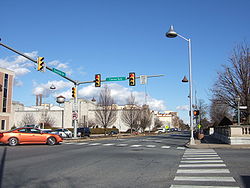
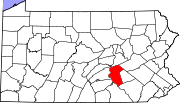
Hershey Downtown Hershey at the intersection of Chocolate Ave and Cocoa Ave, with the signature Hershey Kiss lights and the Hershey Chocolate Factory in the background Motto: The Sweetest Place on Earth Location within Pennsylvania Coordinates: 40°16′42″N 76°39′4″W / 40.27833°N 76.65111°WCoordinates: 40°16′42″N 76°39′4″W / 40.27833°N 76.65111°W Country United States State Pennsylvania County Dauphin Area – Total 14.4 sq mi (37.4 km2) – Land 14.4 sq mi (37.3 km2) – Water 0 sq mi (0.1 km2) Elevation 410 ft (125 m) Time zone Eastern (EST) (UTC-5) – Summer (DST) EDT (UTC-4) FIPS code 34-71385[1] Hershey is a census-designated place (CDP) in Derry Township, Dauphin County in the Commonwealth of Pennsylvania. The community is located 14 miles east of Harrisburg and is part of the Harrisburg–Carlisle Metropolitan Statistical Area. Hershey has no legal status as an incorporated municipality and all municipal services are provided by Derry Township. The population was 13,026 at the 2010 census.
It is popularly called "Chocolatetown, USA." Hershey is also referred to as "The Sweetest Place on Earth."
Contents
Demographics
As of the census[1] of 2010, there were 13,026 people, 5,451 households, and 3,297 families residing in the CDP. The population density was 886.5 people per square mile (342.2/km²). There were 5,887 housing units at an average density of 408.7/sq mi (157.7/km²). The racial makeup of the CDP was 91.07% white, 2.12% African American, 0.06% Native American, 4.87% Asian, 0.01% Pacific Islander, 0.49% from other races, and 1.38% from two or more races. Hispanic or Latino of any race were 1.55% of the population.
There were 5,451 households out of which 24.8% had children under the age of 18 living with them, 50.9% were married couples living together, 7.1% had a female householder with no husband present, and 39.5% were non-families. 33.7% of all households were made up of individuals and 16.2% had someone living alone who was 65 years of age or older. The average household size was 2.22 and the average family size was 2.86.
In the CDP the population was spread out with 20.3% under the age of 18, 7.4% from 18 to 24, 27.0% from 25 to 44, 21.8% from 45 to 64, and 23.5% who were 65 years of age or older. The median age was 42 years. For every 100 females there were 86.3 males. For every 100 females age 18 and over, there were 82.1 males.
The median income for a household in the CDP was $48,496, and the median income for a family was $63,385. Males had a median income CDP was $28,487. About 3.8% of families and 6.9% of the population were below the poverty line, including 6.9% of those under age 18 and 4.7% of those age 65 or over.
Transportation
Hershey is accessible via Harrisburg International Airport, approximately 8 miles away. Amtrak's Keystone Service provides frequent rail service to the nearby towns of Middletown (9 miles), Harrisburg (13 miles)and Elizabethtown.Hershey uses cars and trains to go places as well as CAT and LT (formerly known as COLT) provide bus service.
From 1944 to 1981, Hershey had its own small general aviation airport.[2]
Education
- Derry Township School District – public school
- The Vista School – a state approved, private school for children aged 3 to 21 years who are diagnosed with autism.
- Milton Hershey School – a private philanthropic school founded in 1909 by chocolate magnate Milton Hershey to serve underprivileged children. Currently serves children from prekindergarten through twelfth grade.
Sports
Club League Venue Established Championships Hershey Bears AHL, Ice hockey Giant Center 1932 11 Hershey Haymakers NALL, Lacrosse Giant Center 2011 Hershey was once home to the Hershey Wildcats of the A-League. This professional soccer team was folded after the 2001 season by its owners, who decided that it would not be successful financially. The Wildcats were named after a popular roller-coaster in Hersheypark. Hershey was also home to the Hershey Impact over the AISL indoor soccer league.
National Basketball Association player Wilt Chamberlain scored 100 points for the Philadelphia Warriors in a regular season game played at Hersheypark Arena in 1962; his effort remains a single-game record for the league.
Points of interest
The community is home to The Hershey Company which also makes the well-known Hershey bar and Hershey's Kisses, as well as the parent to the H. B. Reese Candy Company, manufacturer of Reese's Peanut Butter Cups. Hershey's Chocolate World is a factory store and virtual tour ride of The Hershey Company. Hershey Entertainment and Resorts Company owns and operates Hersheypark, Hersheypark Stadium and other attractions such as ZooAmerica, Hershey Gardens, and is a major employer of the community and surrounding area. The Penn State Milton S. Hershey Medical Center and the Milton Hershey School for underprivileged youth are also located in Hershey. The Pennsylvania State Police Academy is located north town along Hersheypark Drive. In addition the Derry Township Police Department is a nationally recognized law enforcement agency.
- GIANT Center, home of the Hershey Bears
- Hershey's Chocolate World
- Hershey Community Center Building
- Hersheypark Arena
- Hersheypark Stadium
- Hotel Hershey
- Milton S. Hershey Mansion
- Hershey Museum
- Hersheypark
- The Hershey Lodge
- Milton Hershey School
- Hershey Area Playhouse
- Hershey Public Library
- Hershey Shopping Outlets
- Parkview Cross Country Course
See also
- Milton S. Hershey
- Derry Township, Pennsylvania
- H. B. Reese
- Reese's Peanut Butter Cups
- Ocean Blue, The
- Penn State Hershey Medical Center
- Derry Township Police
- Pennsylvania State Police
- Richard Winters
- Hershey Public Library
- Brian Baker (actor), aka "The Sprint Guy"
- Terry Farrell (actress)
- Jules Jordan
References
- ^ a b "American FactFinder". United States Census Bureau. http://factfinder.census.gov. Retrieved 2008-01-31.
- ^ [1] URL last accessed November 23, 2009.
External links
- Hershey, Pennsylvania from Wikitravel
- Hershey Community Archives website
- Preserve Hershey organization
- The Sun newspaper
- Hershey New Years.org
Municipalities and communities of Dauphin County, Pennsylvania City Boroughs Berrysburg | Dauphin | Elizabethville | Gratz | Halifax | Highspire | Hummelstown | Lykens | Middletown | Millersburg | Paxtang | Penbrook | Pillow | Royalton | Steelton | Williamstown
Townships Conewago | Derry | East Hanover | Halifax | Jackson | Jefferson | Londonderry | Lower Paxton | Lower Swatara | Lykens | Middle Paxton | Mifflin | Reed | Rush | South Hanover | Susquehanna | Swatara | Upper Paxton | Washington | Wayne | West Hanover | Wiconisco | Williams
CDPs Bressler-Enhaut-Oberlin | Colonial Park | Hershey | Lawnton | Linglestown | Paxtonia | Progress | Rutherford | Skyline View
Unincorporated
communitiesBachmanville | Beaufort Farms | Dietrich | Deodate | Carsonville | Catalina | Ebenezer | Edgemont | Ellendale Forge | Enders | Enterline | Estherton | Fort Hunter | Grantville | Hanoverdale | Hanover Heights | Heckton | Hillside Village | Hockersville | Hoernerstown | Inglenook | Jednota | Killinger | Loyalton | Lucknow | Manada Gap | Manada Hill | Matamoras | Montrose Park | Oakleigh | Oakmont | Oberlin Gardens | Paxtang Manor | Palmdale | Piketown | Powells Valley | Ridgeview | Ritzie Village | Rockville | Sand Beach | Shellsville | Singersville | Swatara | Vaughn | Union Deposit | Waynesville | Windsor Farms
Categories:- Hershey, Pennsylvania
- Populated places established in 1903
- Harrisburg metropolitan area
- Company towns in Pennsylvania
- Census-designated places in Dauphin County, Pennsylvania
Wikimedia Foundation. 2010.


