- Drumcarban
-
Drumcarban
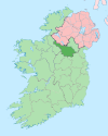
Droim Chearbán— Town — Location in Ireland Coordinates: 53°56′N 7°29′W / 53.93°N 7.49°WCoordinates: 53°56′N 7°29′W / 53.93°N 7.49°W Country Ireland Province Ulster County County Cavan Elevation 112 m (367 ft) Population (2006) – Urban 556 Time zone WET (UTC+0) – Summer (DST) IST (WEST) (UTC-1) Irish Grid Reference N329987 Drumcarban (Irish: Droim Chearbán) is a townland in County Cavan, Ireland. The village lies just off the R198 regional road.
References
- "Population of each Province, County, City, urban area, rural area and Electoral Division, 2002 and 2006". Census Statistics Office Ireland. 2006. http://www.cso.ie/census/documents/2006_prelim_table04.pdf.
Places in County Cavan Towns Villages - Agharaskilly
- Aghavoher
- Arvagh
- Ballinagh (Bellananagh)
- Ballyconnell
- Ballyhaise
- Ballymagauran
- Ballymagovern
- Bawnboy
- Berrymount
- Blacklion
- Butlersbridge
- Canningstown
- Cavanagh
- Cloncollow
- Crossdoney
- Cullyleenan
- Derryginny
- Dowra
- Kilcogy
- Killashandra
- Kilnacreeva
- Kilnaleck
- Lisnahederna
- Milltown
- Mountnugent
- Mullagh
- Mullaghduff
- Rakeelan
- Redhills
- Stradone
- Swanlinbar
Landforms Category:Geography of County CavanCategories:- County Cavan geography stubs
- Towns and villages in County Cavan
Wikimedia Foundation. 2010.


