Wynyard County

Wynyard County
Wynyard
New South Wales
Wynyard NSW.PNG
Location in New South Wales
Lands administrative divisions around Wynyard
Bourke Clarendon Harden
Mitchell Wynyard Buccleuch
Goulburn Selwyn Selwyn
Map of Wynyard county from 1897 showing the parishes
The Murrumbidgee River at Gundagai; the boundary between Wynyard and Clarendon

Wynyard County is one of the 141 Cadastral divisions of New South Wales. It contains the city of Wagga Wagga. The Murrumbidgee River lies on the northern edge of the county, and the Tumut River on the eastern edge.

Wynyard County was named in honour of Major-General Robert Henry Wynyard (1802-1864).[1]

Parishes within this county

A full list of parishes found within this county; their current LGA and mapping coordinates to the approximate centre of each location is as follows:

Parish LGA Coordinates
Adelong Tumut Shire Council 35°1854S 148°0204E / 35.315°S 148.03444°E / -35.315; 148.03444 (Adelong)
Bago Tumbarumba Shire Council 35°3754S 147°5904E / 35.63167°S 147.98444°E / -35.63167; 147.98444 (Bago)
Bangus Gundagai Shire Council 35°0854S 147°5804E / 35.14833°S 147.96778°E / -35.14833; 147.96778 (Bangus)
Batlow Tumut Shire Council 35°2754S 148°1004E / 35.465°S 148.16778°E / -35.465; 148.16778 (Batlow)
Belmore City of Wagga Wagga 35°2854S 147°5304E / 35.48167°S 147.88444°E / -35.48167; 147.88444 (Belmore Parish)
Blanch City of Wagga Wagga 35°1654S 147°5104E / 35.28167°S 147.85111°E / -35.28167; 147.85111 (Blanch)
Book Book City of Wagga Wagga 35°2154S 147°3004E / 35.365°S 147.50111°E / -35.365; 147.50111 (Book Book)
Borambula City of Wagga Wagga 35°0954S 147°3804E / 35.165°S 147.63444°E / -35.165; 147.63444 (Borambula)
Bulalgee Greater Hume Shire Council 35°3354S 147°4204E / 35.565°S 147.70111°E / -35.565; 147.70111 (Bulalgee)
Califat Tumut Shire Council 35°1454S 148°0504E / 35.24833°S 148.08444°E / -35.24833; 148.08444 (Califat)
Carabost Greater Hume Shire Council 35°3654S 147°4104E / 35.615°S 147.68444°E / -35.615; 147.68444 (Carabost)
Coreinbob City of Wagga Wagga 35°1454S 147°3904E / 35.24833°S 147.65111°E / -35.24833; 147.65111 (Coreinbob)
Courabyra Tumbarumba Shire Council 35°3954S 148°0104E / 35.665°S 148.01778°E / -35.665; 148.01778 (Courabyra)
Cunningdroo City of Wagga Wagga 35°0854S 147°3204E / 35.14833°S 147.53444°E / -35.14833; 147.53444 (Cunningdroo)
Dutzon Tumut Shire Council 35°2154S 147°5404E / 35.365°S 147.90111°E / -35.365; 147.90111 (Dutzon)
Ellerslie Tumut Shire Council 35°1454S 147°5604E / 35.24833°S 147.93444°E / -35.24833; 147.93444 (Ellerslie)
Euadera Tumut Shire Council 35°1554S 148°0004E / 35.265°S 148.00111°E / -35.265; 148.00111 (Euadera)
Gadara Tumut Shire Council 35°1854S 148°0704E / 35.315°S 148.11778°E / -35.315; 148.11778 (Gadara)
Gilmore Tumut Shire Council 35°2254S 148°0904E / 35.38167°S 148.15111°E / -35.38167; 148.15111 (Gilmore)
Goldspink Tumbarumba Shire Council 35°3754S 147°5504E / 35.63167°S 147.91778°E / -35.63167; 147.91778 (Goldspink)
Gregadoo City of Wagga Wagga 35°1454S 147°2704E / 35.24833°S 147.45111°E / -35.24833; 147.45111 (Gregadoo)
Gumly Gumly City of Wagga Wagga 35°0954S 147°2804E / 35.165°S 147.46778°E / -35.165; 147.46778 (Gumly Gumly)
Hillas Tumut Shire Council 35°2954S 148°0004E / 35.49833°S 148.00111°E / -35.49833; 148.00111 (Hillas)
Hindmarsh Tumut Shire Council 35°2754S 148°0604E / 35.465°S 148.10111°E / -35.465; 148.10111 (Hindmarsh)
Humula City of Wagga Wagga 35°2854S 147°4604E / 35.48167°S 147.76778°E / -35.48167; 147.76778 (Humula)
Keajura City of Wagga Wagga 35°1954S 147°3904E / 35.33167°S 147.65111°E / -35.33167; 147.65111 (Keajura)
Kilgowla City of Wagga Wagga 35°2354S 147°3804E / 35.39833°S 147.63444°E / -35.39833; 147.63444 (Kilgowla)
Kyeamba City of Wagga Wagga 35°2354S 147°2904E / 35.39833°S 147.48444°E / -35.39833; 147.48444 (Kyeamba)
Livingstone City of Wagga Wagga 35°2254S 147°2604E / 35.38167°S 147.43444°E / -35.38167; 147.43444 (Livingstone)
Mate City of Wagga Wagga 35°2654S 147°5104E / 35.44833°S 147.85111°E / -35.44833; 147.85111 (Mate)
Minjary Tumut Shire Council 35°1554S 148°1004E / 35.265°S 148.16778°E / -35.265; 148.16778 (Minjary)
Mundarlo Gundagai Shire Council 35°0654S 147°5104E / 35.115°S 147.85111°E / -35.115; 147.85111 (Mundarlo)
Murraguldrie City of Wagga Wagga 35°2754S 147°3604E / 35.465°S 147.60111°E / -35.465; 147.60111 (Murraguldrie)
Nacki Nacki Tumut Shire Council 35°2154S 147°5804E / 35.365°S 147.96778°E / -35.365; 147.96778 (Nacki Nacki)
Oberne City of Wagga Wagga 35°2054S 147°4804E / 35.34833°S 147.80111°E / -35.34833; 147.80111 (Oberne)
Rowan City of Wagga Wagga 35°1454S 147°2204E / 35.24833°S 147.36778°E / -35.24833; 147.36778 (Rowan)
Selwyn Tumut Shire Council 35°3354S 148°0904E / 35.565°S 148.15111°E / -35.565; 148.15111 (Selwyn)
South Gundagai Gundagai Shire Council 35°0354S 148°0904E / 35.065°S 148.15111°E / -35.065; 148.15111 (South Gundagai)
South Wagga Wagga City of Wagga Wagga 35°0754S 147°2104E / 35.13167°S 147.35111°E / -35.13167; 147.35111 (South Wagga Wagga)
Tarcutta Gundagai Shire Council 35°1054S 147°4504E / 35.18167°S 147.75111°E / -35.18167; 147.75111 (Tarcutta)
Tarrabandra Gundagai Shire Council 35°0854S 148°1004E / 35.14833°S 148.16778°E / -35.14833; 148.16778 (Tarrabandra)
Tumut Tumut Shire Council 35°1654S 148°1004E / 35.28167°S 148.16778°E / -35.28167; 148.16778 (Tumut)
Tywong City of Wagga Wagga 35°1454S 147°3304E / 35.24833°S 147.55111°E / -35.24833; 147.55111 (Tywong)
Umbango City of Wagga Wagga 35°2654S 147°4604E / 35.44833°S 147.76778°E / -35.44833; 147.76778 (Umbango)
Umutbee City of Wagga Wagga 35°1454S 147°4504E / 35.24833°S 147.75111°E / -35.24833; 147.75111 (Umutbee)
Wallace Tumut Shire Council 35°1754S 147°5404E / 35.29833°S 147.90111°E / -35.29833; 147.90111 (Wallace)
Wereboldera Tumut Shire Council 35°2254S 148°1304E / 35.38167°S 148.21778°E / -35.38167; 148.21778 (Wereboldera)
Willie Ploma Gundagai Shire Council 35°0854S 148°0304E / 35.14833°S 148.05111°E / -35.14833; 148.05111 (Willie Ploma)
Wondalga Tumut Shire Council 35°2354S 148°0504E / 35.39833°S 148.08444°E / -35.39833; 148.08444 (Wondalga)
Wood Greater Hume Shire Council 35°3754S 147°5004E / 35.63167°S 147.83444°E / -35.63167; 147.83444 (Wood)
Woomahrigong City of Wagga Wagga 35°1654S 147°2504E / 35.28167°S 147.41778°E / -35.28167; 147.41778 (Woomahrigong)
Yabtree Gundagai Shire Council 35°0654S 147°4504E / 35.115°S 147.75111°E / -35.115; 147.75111 (Yabtree)
Yaven Gundagai Shire Council 35°1154S 147°5104E / 35.19833°S 147.85111°E / -35.19833; 147.85111 (Yaven)

References

  1. ^ Geographical Names Board of NSW

Wikimedia Foundation. 2010.

Игры ⚽ Нужен реферат?

Look at other dictionaries:

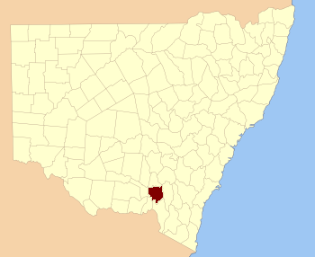
  • Wynyard County, New South Wales — Infobox Australian cadastral name = Wynyard state = New South Wales caption = Location in New South Wales near nw = Bourke near n = Clarendon near ne = Harden near e = Buccleuch near se = Selwyn near s = Selwyn near sw = Goulburn near w =… …   Wikipedia

  • Wynyard Park, County Durham — Wynyard Park, sometimes known as Wynyard Hall is a large country house in County Durham, England. The house used to be the family seat of the Vane Tempest Stewart family, Marquesses of Londonderry, but it was sold in the 1980s and currently… …   Wikipedia

  • Wynyard — may refer to:Australia: *Wynyard, the district of Sydney CBD around Wynyard railway station, Sydney *Wynyard Park, Sydney *Wynyard, TasmaniaUnited Kingdom: *Wynyard Park, County Durham *Wynyard Woods a housing estate in Stockton on Tees *Wynyard… …   Wikipedia

  • Wynyard Park — may refer to: * Wynyard Park, a stately home in County Durham, England (formerly a seat of the Marquesses of Londonderry) * Wynyard Park, a public park in Sydney …   Wikipedia

  • Electoral district of Wynyard — Wynyard was a former electoral district for the Legislative Assembly in the Australian State of New South Wales from 1904 to 1913, including Tumut and named after Wynyard County. It replaced Tumut and Gundagai. Its only member was Robert Thomas… …   Wikipedia

  • Goulburn County — Map of all coordinates from Google Map of all coordinates from Bing Export all coordinates as KML …   Wikipedia

  • Clarendon County, New South Wales — Map of all coordinates from Google Map of all coordinates from Bing Export all coordinates as KML …   Wikipedia

  • Goulburn County, New South Wales — Infobox Australian cadastral name = Goulburn state = New South Wales caption = Location in New South Wales near nw = Mitchell near n = Wynyard near ne = Wynyard near e = Selwyn near se = Selwyn near s = Benambra (Vic) near sw = Bogong (Vic) near… …   Wikipedia

  • Teddy Wynyard — Infobox Historic Cricketer nationality = English country = England country abbrev = ENG name = Teddy Wynyard picture = Cricket no pic.png batting style = Right hand bat bowling style = tests = 3 test runs = 72 test bat avg = 12.00 test 100s/50s …   Wikipedia

  • Buccleuch County, New South Wales — Infobox Australian cadastral name = Buccleuch state = New South Wales caption = Location in New South Wales near nw = Clarendon near n = Harden near ne = Harden near e = Cowley near se = Wallace near s = Wallace near sw = Selwyn near w =… …   Wikipedia
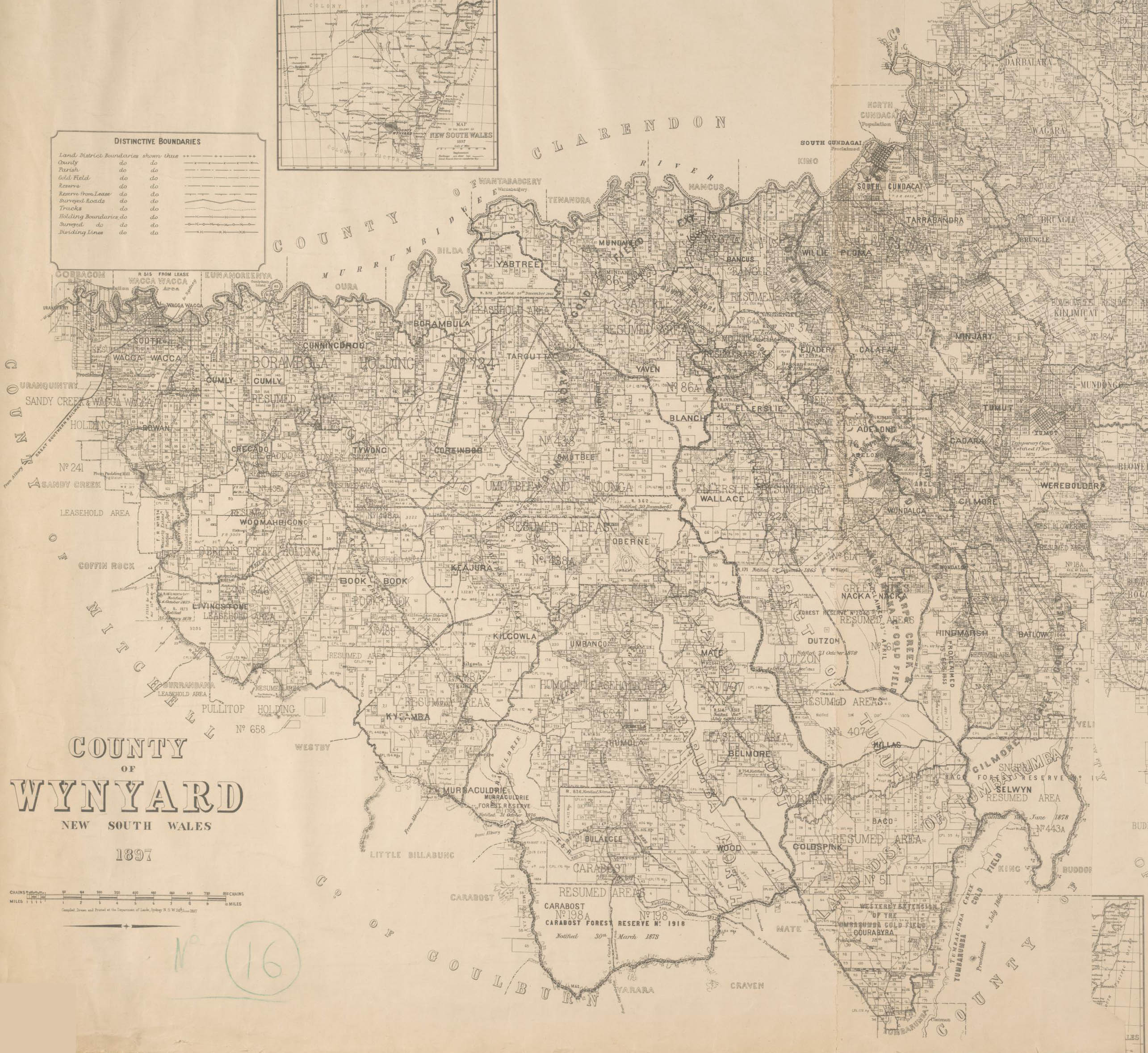
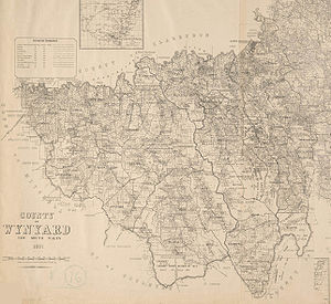
Share the article and excerpts

Direct link
https://en-academic.com/dic.nsf/enwiki/11583986 Do a right-click on the link above
and select “Copy Link”