- Summit Avenue (Hudson Palisades)
-
County Route 617
Summit Avenue Route information Length: 4.55 mi[1] (7.32 km) Major junctions South end:  CR 622 in Jersey City
 NJ 139 in Jersey City
 NJ 495 in Union City
North end:  CR 691 in Union City
Highway system County routes in New Jersey
500-series • County routes in Hudson County←  CR 616
CR 618  →
→County Route 617 is 4.55 miles (7.32 km) long and follows one street, Summit Avenue along the ridge of the Hudson Palisades in Hudson County, New Jersey. Its southern end is CR 622, or Grand Street, at Communipaw Junction in the Bergen-Lafayette Section of Jersey City (although Summit Avenue continues one block south to Garfield and Communipaw Avenues without county maintenance). Its northern end is CR 691, 32nd Street, a section of the Bergen Turnpike, in Union City.[2]
Contents
History
The route of the avenue follows a Lenape trail, used by the Hackensack Indians between their summer encampment at Communipaw on the Upper New York Bay and a more permanent settlement at Overpeck Creek. In the 16th century it was also used by early European settlers to region, first at Pavonia and later Bergen, that was part of the provincial colony of New Netherland. The ferry landing (nearby the present site of Liberty Science Center), was used by village on the bay as well the one on the hill (at today's Bergen Square) to travel to New Amsterdam. The trail continued north through Bergen Woods before descending and crossing the Hackensack Meadows.
Geography
 The Five Corners Branch Library in Jersey City.
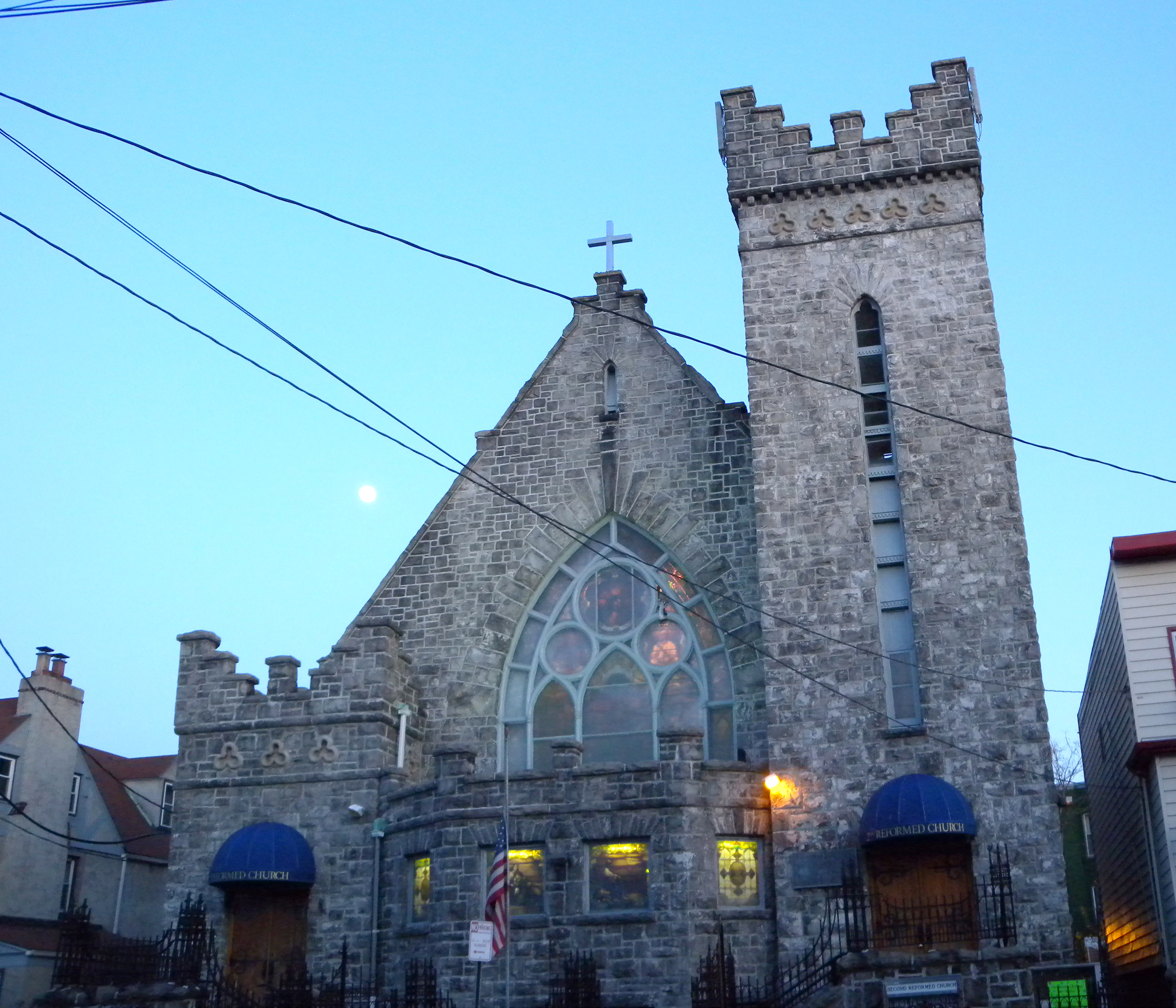
 The Secomd Reformed Church
Summit Avenue starts at the foot of Bergen Hill, the southern emergence of the Palisades, and is the central street of the New Jersey Register of Historic Places state-designated Bergen Hill Historic District,[3] which includes St. Johns Episcopal Church.[4] It travels northward to the former Jersey City Medical Center, a national historic site being restored and converted to a gated neighborhood, The Beacon and crosses Montgomery Street just east of McGinley Square. Passing the Jersey City Armory,[5] it enters the Journal Square district and at Academy Street is two blocks east of Bergen Square. The Jersey City Municipal Courts are also near the intersection. At Sip Avenue a bridge traverses the former Pennsylvania Railroad Jersey City Branch cut. It was at this location 1910 the Hudson and Manhattan Railroad opened the Summit Avenue Station[6] which has now become part of the Journal Square Transportation Center used by the Port Authority Trans Hudson rapid transit system. At the southeast side of the bridge is the New Jersey state office building,[7] while at the northeast stands one of the oldest buildings in New Jersey, built by descendents of the first Dutch settlers.[8] Summit Avenue is one of the streets that creates the Five Corners, the other two being early components of the Newark Plank Road. The area is the county seat of Hudson County, and home to the landmark Hudson County Courthouse. The concentration of Filipino-American creates a Little Manila, while one long block west is the India Square neighborhood. After crossing the Bergen Arches, the Long Dock Tunnel, and the The Divided Highway, Summit Avenue enters central section of Jersey City Heights, and passes the site of JC Reservoirs #3 (a nature preserve)[9] and #4 (demolished), and Pershing Field, a major park in the district. The avenue becomes more residential, with examples of Victorian and Edwardian-era homes, and pre-war low rise apartment buildings. The Second Reformed Church of Hudson City is located on the avenue.[10]
 Hudson Presbyterian Church
 Historical marker in Union City where Joe Jeanette's home and gym once stood.
Summit Avenue crosses the Union City line at Transfer Station It is here that it intersects Paterson Plank Road, which runs to the New Jersey Meadowlands. Summit Avenue was the "downtown" of the former municipality of West Hoboken, and is still a busy commercial district.[11] A theater from the period is now the Summit Quadplex cinema.[12] The Summit Avenue Historic Commercial District, which runs from 9th to 32nd Streets was designated by the New Jersey Register of Historic Places in 1985.[3] At 18th Street the city's newest branch library is located at a public school named for Jose Marti, in recognition of the city's large Cuban-American community. Both are built on the grounds of the former Monastery and Church of Saint Michael the Archangel rising just east of the avenue. At 27th Street a memorial to Joe Jeanette, a native son and famous boxer, is found.[13] Soon after it passes Union City High School, completed in 2009 on the site of the former Roosevelt Stadium, where Babe Ruth and Lou Gehrig played exhibition baseball games, and where National Football League greats Lou Cordileone and Frank Winters played during their high school days. It crosses over New Jersey Route 495, a cut which leads into the Lincoln Tunnel. Summit Avenue ends at the 32nd Street section of the Hackensack Plank Road near the Kennedy Center (the landmark former Sears Roebuck and Company building), the Park Theater,[14] and Schuetzen Park on Kennedy Boulevard.[15]
The North Hudson County Railway built trolley line along the avenue. Until bustitution the Public Service Railway operated streetcar lines along the avenue which is now served by New Jersey Transit bus #85 and #82.
See also
References
- ^ "Hudson County 617 straight line diagram" (PDF). New Jersey Department of Transportation. http://www.state.nj.us/transportation/refdata/sldiag/09000617__-.pdf. Retrieved 2009-08-02.
- ^ Hudson County New Jersey Street Map. Hagstrom Map Company, Inc. 2008. ISBN 0-88097-763-9.
- ^ a b NJ State Register of Historic Places in Hudson County
- ^ St John Espiscopl Church
- ^ Jersey City Armory
- ^ Summit Avenue Station (1912)
- ^ Thorbourne, Ken, The Jersey Journal Tuesday September 30, 2008 Second bomb scare shuts state office building in Journal Square
- ^ Newkirk House
- ^ http://new.jcreservoir.org/?page_id=43
- ^ Second Reformed Church of Hudson City
- ^ Staab, Amanda. "Attracting shoppers to Summit Ave.", The Union City Reporter, May 10, 2009, pages 3 and 11
- ^ "UC to host first ever film premiere in the city" The Union City Reporter August 22, 2010; page 5
- ^ Joe Jeanette memorial
- ^ "Directions and Parking" Park Performing Arts Center, accessed December 4, 2010.
- ^ Schuetzen Park in North Bergen, Germany in NYC, accessed November 28, 2010.
External links
- 40°42′57″N 74°04′02″W / 40.71592°N 74.06715°W - Southern terminus of CR 617
- 40°46′28″N 74°01′53″W / 40.77440°N 74.03128°W - Northern terminus of CR 617 and Summit Avenue
- Reservoir #3
Categories:- Streets in Hudson County
- Transportation in Hudson County, New Jersey
- Neighborhoods in Hudson County, New Jersey
- Historic districts in Hudson County, New Jersey


Wikimedia Foundation. 2010.