- Central Avenue (Hudson Palisades)
-
County Route 663 Central Avenue Route information Length: 1.60 mi[1] (2.57 km) Major junctions South end:  CR 644 in Jersey City
 NJ 139 in Jersey City
North end:  CR 681 in Jersey City
Highway system County routes in New Jersey
500-series • County routes in Hudson County←  CR 662
CR 664  →
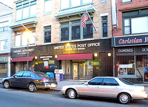
→County Route 663 is 1.60-mile (2.57 km) long Central Avenue in Jersey City Heights, and is the main commercial thoroughfare for that section of Jersey City, New Jersey. It runs between Newark Avenue near Five Corners and Paterson Plank Road near Transfer Station. The avenue continues north through Union City without the county route designation to 35th Street (CR 674[2]), two blocks norrth of Hackensack Plank Road.[3]
Central Avenue was the "Main Street" of Hudson City, one of the municipalities which elected to join Jersey City in a referendum held in 1863. The avenue begins at what had been the southern border of the town that is now near the county seat of Hudson County and the historic Hudson County Courthouse. Travelling north it almost immediately passes over three man-made ravines, or "cuts" through the part of the Hudson Palisades called Bergen Hill. The now-unused Bergen Arches and the single track Long Dock Tunnel were created for railroads, while the The Divided Highway was created to allow traffic to by-pass local roads while travelling between the Holland Tunnel and the Pulaski Skyway.
Upon entering the Heights, it becomes residential for a few blocks, as it passes the Jersey City Reservoir #3 and Pershing Field the section's largest municipal park. Thereafter it becomes a local shopping street. Businesses, retail, and food shops are mostly located in three and four storey buildings, many built in the late 19th and early 20th century. It again becomes more residential as it approaches the city line in Washington Park.
The trajectory of the avenue is adjusted by a short "dog-leg turn" to the west along Paterson Plank Road and resumes in what was formerly West Hoboken and is now a section of Union City. It is a broad residential street of multiple family houses and low and mid rise apartment buildings. At 18th Street the avenue is once again "interrupted", this time at the grounds of the former Monastery and Church of Saint Michael the Archangel. It continues on the other side and soon thereafter passes over the Lincoln Tunnel Approach and Helix. Central Avenue ends two blocks north of the 32nd Street section of the Hackensack Plank Road near the Holy Family Church complex which includes the Park Theater, just west of Bergenline Avenue.
See also
References
- ^ "Hudson County 663 straight line diagram" (PDF). New Jersey Department of Transportation. http://www.state.nj.us/transportation/refdata/sldiag/09000663__-.pdf. Retrieved 2009-08-02.
- ^ "Hudson County 674 straight line diagram" (PDF). New Jersey Department of Transportation. http://www.state.nj.us/transportation/refdata/sldiag/09000674__-.pdf. Retrieved 2009-08-25.
- ^ Hudson County New Jersey Street Map. Hagstrom Map Company, Inc. 2008. ISBN 0-88097-763-9.
Coordinates: 40°44′17″N 74°03′14″W / 40.738°N 74.054°W
External links
Neighborhoods in Jersey City, New Jersey Bergen-Lafayette 
Downtown Exchange Place · Hamilton Park · Harsimus · Holland Tunnel · Pavonia Newport · Paulus Hook · Van Vorst Park · The Village · WALDO/PowerhouseGreenville The Heights Journal Square Meadowlands Upper New York Bay West Side Categories:- Transportation in Hudson County, New Jersey
- Streets in Hudson County
- Neighborhoods in Jersey City, New Jersey
Wikimedia Foundation. 2010.


