- Fort Frances
-
Fort Frances — Town — 
Coat of armsMotto: Industry and perseverance 
 Fort Frances
Coordinates: 48°37′N 93°24′W / 48.617°N 93.4°WCoordinates: 48°37′N 93°24′W / 48.617°N 93.4°W Country  Canada
Province  Ontario
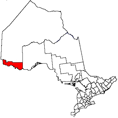
District Rainy River District Settled Incorporated 1903 Government – Mayor Roy Avis – Federal riding Thunder Bay—Rainy River – Prov. riding Kenora—Rainy River Area[1] – Land 26.85 km2 (10.4 sq mi) Population (Canada 2006 Census)[1] – Total 8,103 – Density 301.8/km2 (781.7/sq mi) – Demonym Fort Francesian Time zone CST (UTC−6) – Summer (DST) CDT (UTC−5) Postal code P9A Area code(s) 807 Website www.fort-frances.com Fort Frances is a town in, and the seat of, Rainy River District in Northwestern Ontario, Canada. The population as of the 2006 census was 8,103 and Fort Frances' population peaked in 1971 at 9,947. Fort Frances is a popular fishing destination, it hosts the Fort Frances Canadian Bass Championship annually.
Located on the international border with the United States where Rainy Lake narrows to become Rainy River, it is connected to International Falls, Minnesota, by the Fort Frances-International Falls International Bridge. The town is the third largest community of Northwestern Ontario after Thunder Bay and Kenora, the town offers many shopping and dining outlets. AbitibiBowater is the main industry in Fort Frances.
Contents
History
This was the first European settlement west of Lake Superior; it was established by French Canadian Pierre Gaultier de Varennes et de La Vérendrye, first commander of the western district. In 1731 he built Fort St. Pierre near this spot as support for the fur trade with native peoples. In 1732 his expedition built Fort St. Charles on Magnuson Island on the west side of Lake of the Woods. After some time, Fort St. Pierre fell out of use.[2]
In 1817, following the War of 1812 and redefinition of borders between Canada and the United States, the Hudson's Bay Company (HBC) built a fort here. Officials named the subsequent settlement after Lady Frances Simpson, wife of then Hudson's Bay Company Governor George Simpson, who visited the fort many times.[2]
Incorporated in 1903, the town held a big centennial celebration in 2003.
The main employer is a pulp and paper mill established in the early 1900s. It has had numerous owners over the years, notably Edward Wellington Backus. Now owned by AbitibiBowater, the mill employs about 700 persons.
On June 25, 1946, the town was struck by a tornado which caused major damage. This tornado struck a week after the deadly Windsor tornado.
Transportation
There are three airports in the area, one in the United States. The two local airports are for general aviation and other a privately owned floatplane base.
Ontario Highway 11 and Ontario Highway 71 are two major roads in Fort Frances. Both are part of the Trans Canada Highway and the latter ends in Fort Frances. The town is connected to Kenora via Highway 71, while Highway 11 provides connections to Devlin, Emo, and Rainy River to the west, and Atikokan to the east.
Canadian National Railway travels into Fort Frances with freight traffic only and travels across the International Bridge into the US.
Train, truck and car traffic to and from the United States is via the Fort Frances-International Falls International Bridge over the Rainy River.
Fort Frances Transit operated until 1996 and Fort Frances Handi-Van Transit is a provincial funded service run by the Town of Fort Frances. Caribou Coach Transportation Company Incorporated runs a bus route to and from Thunder Bay. This route was once served by Greyhound Canada.
Climate
Climate data for Fort Frances Month Jan Feb Mar Apr May Jun Jul Aug Sep Oct Nov Dec Year Record high °C (°F) 10
(50)12.2
(54.0)24.4
(75.9)31.7
(89.1)35
(95)40
(104)42.2
(108.0)35.6
(96.1)34.4
(93.9)31.1
(88.0)22.8
(73.0)13.9
(57.0)42.2
(108.0)Average high °C (°F) −10.6
(12.9)−6.4
(20.5)1.1
(34.0)10.3
(50.5)18.8
(65.8)22.9
(73.2)25.4
(77.7)24
(75)17.6
(63.7)10.4
(50.7)0.2
(32.4)−8.1
(17.4)8.8 Daily mean °C (°F) −15.6
(3.9)−11.9
(10.6)−4.2
(24.4)4.3
(39.7)12.4
(54.3)17
(63)19.6
(67.3)18.2
(64.8)12.3
(54.1)6
(43)−3.4
(25.9)−12.4
(9.7)3.5 Average low °C (°F) −20.5
(−4.9)−17.3
(0.9)−9.5
(14.9)−1.7
(28.9)5.9
(42.6)11
(52)13.7
(56.7)12.4
(54.3)7.1
(44.8)1.5
(34.7)−6.9
(19.6)−16.6
(2.1)−1.7 Record low °C (°F) −44.4
(−47.9)−43.3
(−45.9)−37.2
(−35.0)−25.6
(−14.1)−11.1
(12.0)−5
(23)0.6
(33.1)−1.1
(30.0)−17.8
(0.0)−16.7
(1.9)−32
(−26)−40
(−40)−44.4
(−47.9)Precipitation mm (inches) 30.4
(1.197)23.9
(0.941)30.9
(1.217)44.8
(1.764)70.2
(2.764)115.2
(4.535)94.2
(3.709)89.7
(3.531)83.7
(3.295)55.9
(2.201)41.1
(1.618)29.5
(1.161)709.5
(27.933)Source: Environment Canada[3] Demographics
Census Population 1901 697 1911 1,611 1921 3,109 1931 5,470 1941 5,849 1951 8,038 1961 9,481 1971 9,947 1981 8,906 1991 8,891 2001 8,315 2006 8,103 Fort Frances had a population of 8,103 people in 2006, which was a decrease of 2.5% from the 2001 census count. The median household income in 2005 for Fort Frances was $54,859, which is below the Ontario provincial average of $60,455.[1]
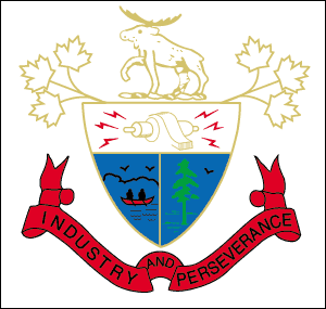
Coat of arms
The city coat of arms features a bull moose; maple leaves; a "Magneto", representative of electricity (industry); two men in a canoe; a white pine tree; and the motto "Industry and Perseverance."
Media
Newspapers
- Fort Frances Times - Daily
- Fort Frances Living - Weekly
- Fort Frances Today - Weekly
Online Media
- NWO Update
Television stations
- CBWCT (channel 5) (CBC, repeats CBWT Winnipeg)
- CBWFT-11 (channel 15) (Radio-Canada, repeats CBWFT Winnipeg)
- Cable 10 - Shaw TV community channel
There are no local CTV, Global or TVO outlets or repeaters; Shaw Cable carries CJBN-TV (CTV) from Kenora, CITV-TV (Global) from Edmonton, and TVO, plus CITY-TV (Citytv), CHCH-TV (independent), CFTM-TV (TVA, live feed) and TFO.
United States network programming on Shaw TV comes from Detroit (WDIV-TV, WXYZ-TV, WWJ-TV, and WTVS) and Rochester (WUHF); stations from the Duluth television market are not available on cable, though they are available over-the-air from repeaters in International Falls.
Radio stations
- FM 89.1 - CKSB-9-FM (Première Chaîne, repeats CKSB, Saint Boniface, Manitoba)
- FM 90.5 - CBQQ-FM (CBC Radio One, repeats CBQT-FM, Thunder Bay)
- FM 93.1 - CFOB-FM, B93, Borderland's Best Music hot adult contemporary
Another radio station, CKWO FM 92.3, was licensed to the neighbouring Couchiching First Nation. The station closed and went silent in 2007.
Education
Elementary and secondary schools
Rainy River District School Board
- Fort Frances High School
- Robert Moore School
- JW Walker School
Northwest Catholic District School Board
- St Michael's School
- St Francis School
Post-secondary schools
Notable Fort Francesians
- Dave Allison, former coach of the NHL's Ottawa Senators
- Mike Allison, former player for the Los Angeles Kings, Toronto Maple Leafs, and New York Rangers of the NHL
- Gene Eugene, actor, musician and recording producer
- Howard Hampton, Member of Provincial Parliament (Ontario) of Kenora—Rainy River (provincial electoral district) and former leader of the Ontario New Democratic Party.
- Chris Lindberg, silver medalist with the Canadian Ice Hockey Team at the 1992 Winter Olympics
- Neil Sheehy, former player for the Calgary Flames, Hartford Whalers and Washington Capitals of the NHL.
- Timothy Sheehy, former NHL player.
- Murray Bannerman, former player for the Chicago Blackhawks.
- Duncan Keith, NHL hockey player of the Chicago Blackhawks.
- Keith "Huffer" Christiansen, former player for the WHA Minnesota Fighting Saints.
- Gene Stoltzfus - founding director of Christian Peacemaker Teams
- Steve Arpin - ARCA Re/Max Series and NASCAR Nationwide Series Race Car Driver
- Todd Dufresne - social and cultural theorist best known for his work on Freud and psychoanalysis
Culture and attractions
- The Fort Frances Museum
- The Border Land Arts Alliance
- Tour de Fort
- Folk Festival
- Pither's Point Park
- Le LaVerendrye Parkway
- Scott Street and Kings Highway Shopping Districts
- Kitchen Creek Golf Club
- Heron Landing Golf Course
- Logging Tug Hallet
- 8th Street Walking & Ski Trails
- Little Beaver Snow Park
- Royal Canadian Legion Park
- Clover Valley Farmer's Market
- City Hall
- The Parkway Tower
- Rendezvous Yacht Club
- The Noden Causeway
Sport
Fort Frances is home to the following amateur sports teams:
- Fort Frances Lakers (Junior ice hockey)
- Fort Frances Thunderhawks (Senior ice hockey)
- Fort Frances Muskies (Football)
- Fort Frances Muskies (Hockey)
Fort Frances was the home of the former amateur sports teams:
- Fort Frances Borderland Thunder (Junior ice hockey)
- Fort Frances Canadians (Senior ice hockey)
- Fort Frances Royals (Junior ice hockey)
Sporting facilities include:
- Memorial Sports Center
- Energy Fitness Centre
- Curves For Woman
Sources
- ^ a b c "Fort Frances community profile". 2006 Census data. Statistics Canada. http://www12.statcan.ca/census-recensement/2006/dp-pd/prof/92-591/details/page.cfm?B1=All&Code1=3559012&Code2=35&Custom=&Data=Count&Geo1=CSD&Geo2=PR&Lang=E&SearchPR=01&SearchText=Fort+Frances&SearchType=Begins. Retrieved 2011-05-03.
- ^ a b "A Short History of Fort Frances". Town of Fort Frances. http://www.fort-frances.com/heritage. Retrieved 2011-05-03.
- ^ Environment Canada—Canadian Climate Normals 1971–2000, accessed 8 November 2009
External links

Unorganized Rainy River Couchiching 16A Alberton 
Agency 1  Fort Frances

International Falls, MN Ranier, MN Towns Fort Frances • Rainy River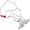
Townships Indian reserves Agency 1 • Big Grassy River 35G • Big Island Mainland 93 • Couchiching 16A • Long Sault 12 • Manitou Rapids 11 • Neguaguon Lake 25D • Rainy Lake • Sabaskong Bay 35C • Saug-a-Gaw-Sing 1 • Seine RiverUnorganized areas See also: Communities in Rainy River District • Census divisions of OntarioCategories:- Fort Frances
- Hudson's Bay Company forts

Wikimedia Foundation. 2010.