- Cleadale, Eigg
-
Coordinates: 56°55′11″N 6°08′58″W / 56.91959°N 6.14934°W
Cleadale 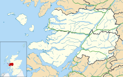
 Cleadale
Cleadale shown within the Lochaber areaOS grid reference NM475885 Council area Highland Country Scotland Sovereign state United Kingdom Postcode district PH42 4 Police Northern Fire Highlands and Islands Ambulance Scottish EU Parliament Scotland List of places: UK • Scotland • Cleadale is a settlement on the north west side of the island of Eigg, in the Small Isles of Scotland and is in the council area of Highland.
Settlements Ach' An Todhair • Achaphubuil • Acharacle • Achnaha • Achluachrach • Achriabhach • Ardechive • Ardshealach • Arisaig • Back of Keppoch • Ballachulish • Banavie • Blaich • Cleadale • Corpach • Corran • Druimarben • Fort William • Glenborrodale • Glencoe • Glenfinnan • Glenuig • Inverie • Kilchoan • Kilmory • Kinlochleven • Lochaline • Mallaig • Morar • Ockle • Onich • Portuairk • Roybridge • Sanna • Spean Bridge • StrontianGeography Landmarks Glencoe House • Mingarry Castle • Castle TioramTransport Categories:- Populated places in Lochaber
- Villages in the Inner Hebrides
- Highland geography stubs

Wikimedia Foundation. 2010.