- All Saints' Church, St Helens
-
All Saints' Church, St Helens 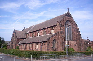
All Saints' Church, St Helens, from the northwestLocation in Merseyside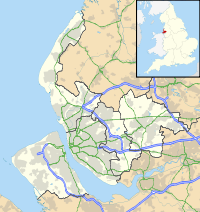
 All Saints' Church, St Helens
Coordinates: 53°26′14″N 2°42′12″W / 53.4373°N 2.7033°W OS grid reference SJ 534 936 Location Ellamsbridge Road, Sutton,
St Helens, MerseysideCountry England Denomination Anglican Website All Saints, Sutton History Founded 4 August 1891 Consecrated 14 October 1893 Architecture Status Parish church Functional status Active Heritage designation Grade II Designated 2 June 1988 Architect(s) Paley, Austin and Paley Architectural type Church Style Gothic Revival Groundbreaking 4 August 1891 Completed 1893 Specifications Materials Sandstone, cement-tile roofs Administration Parish Sutton Deanery Saint Helens Archdeaconry Warrington Diocese Liverpool Province Province of York Clergy Vicar(s) Revd Mark Taylor All Saints' Church, St Helens, is located in Ellamsbridge Road, Sutton, St Helens, Merseyside, England. It is an active Anglican parish church in the deanery of Saint Helens, the archdeaconry of Warrington, and the diocese of Liverpool. Its benefice is united with those of St Nicholas, Sutton, and St Michael and All Angels, Sutton, to form the Sutton Team.[1] The church has been designated by English Heritage as a Grade II listed building.[2]
Contents
History
All Saints was built between 1891 and 1893, and designed by the Lancaster firm of architects, Paley, Austin and Paley.[3] The land and a donation of £1,000 (£80,000 as of 2011)[4] were given by the lord of the manor, William Pilkington of the Pilkington glass manufacturing firm. The foundation stone was laid by Pilkington's daughter on 4 August 1891, and the church was consecrated on 14 October 1893 by the Rt Revd John Ryle, Bishop of Liverpool.[5] The architects planned for a tower on the crossing, but this was never built.[3]
Architecture
Exterior
The church is constructed in red sandstone, and has cement-tile roofs. Its plan is cruciform, and consists of a five-bay nave with a clerestory, north and south aisles, a southwest porch, north and south transepts, and a two-bay chancel with a chapel and a vestry. The architectural style is Gothic Revival. The windows in the aisles and clerestory have three lights, and those in the chapel and vestry have two lights. At the west end are buttresses and a four-light window. The east window has five lights and contains staggered transoms.[2]
Interior
The authors of the Buildings of England series describe the interior as being "impressive" and "dignified".[3] The arcades are carried on octagonal piers with moulded capitals.[2] The piers at the crossing are massive, having been built in preparation for the unbuilt tower. At the west end of the church, two bays have been converted into a parish room, with a glazed screen between it and the rest of the church. The stained glass in the east window is a memorial to the Pilkington family; it was made in 1905 by Shrigley and Hunt.[3] The organ dates from 1900 and was given by William Pilkington.[2]
See also
- List of works by Paley, Austin and Paley
References
- ^ All Saints, Sutton, Sutton, Church of England, http://www.achurchnearyou.com/sutton-all-saints-church/, retrieved 5 November 2011
- ^ a b c d Church of All Saints, St. Helens (1260566). National Heritage List for England. English Heritage. Retrieved 5 November 2011.
- ^ a b c d Pollard, Richard; Pevsner, Nikolaus (2006), Lancashire: Liverpool and the South-West, The Buildings of England, New Haven and London: Yale University Press, p. 567, ISBN 0-300-10910-5
- ^ UK CPI inflation numbers based on data available from Lawrence H. Officer (2010) "What Were the UK Earnings and Prices Then?" MeasuringWorth.
- ^ Wainwright, Stephen, An Illustrated History of Old Sutton in St.Helens: History of Religion in Sutton, St.Helens; Introduction (published 2011), http://www.suttonbeauty.org.uk/suttonhistory/religion.html#introduction, retrieved 5 November 2011
Categories:- Church of England churches in Merseyside
- Grade II listed churches
- Grade II listed buildings in Merseyside
- Religious buildings completed in 1893
- 19th-century Church of England church buildings
- Gothic Revival architecture in Merseyside
- Anglican Diocese of Liverpool
- Paley, Austin and Paley buildings


Wikimedia Foundation. 2010.