- December 1969 nor'easter
-
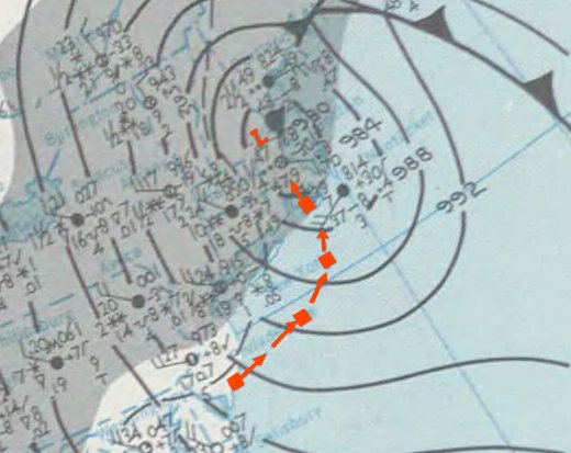
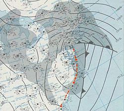 Surface weather analysis of the nor'easter, with its track highlighted in red
The December 1969 nor'easter was an intense winter nor'easter that impacted the Mid-Atlantic and New England regions of the United States between December 25 and December 28, 1969. A high-end Category 3 or low-end Category 4 on the Northeast Snowfall Impact Scale, the storm developed over Texas by December 25 and advanced eastward. On reaching the Eastern Seaboard, it intensified and turned northeastward, accelerating toward New England. There, the worst of the storm was felt on December 26 and 27. The low peaked in severity with a minimum barometric pressure of 976 millibars (28.8 inHg) as it began pulling away from New England. The slow movement of the cyclone led to extremely heavy snowfall totals throughout the interior Northeastern United States, reaching 40 inches (100 cm) in localized areas, although an influx of warmer air turned the precipitation to rain near the coast.
Due to a number of factors, including the high water content of the snow, pre-existing snowpack, and equipment failures, the storm proved difficult to recover from in Upstate New York and Vermont. Depths exceeding 1 ft (0.30 m) were reported as far south as Washington, D.C.. Drifts up to 30 ft (9.1 m) high blocked roadways, and at least 20 deaths were blamed on the nor'easter. In the hardest-hit areas, snow removal on roadways was severely delayed, isolating some communities. Following the storm, strong winds impeded cleanup efforts, and flooding became an issue near the coast as a result of excessive rainfall and ice jams.
Contents
Background
The winter of 1969–1970 continued a long-term El Niño from the previous winter,[1] which produced two significant storms in the Northeast United States, including the "Lindsay storm".[2] North Atlantic Oscillation (NAO) values ranged from neutral to negative during the general time frame of the nor'easter, trending more consistently negative in the days surrounding its genesis. NAO values became significantly negative immediately following the storm, signaling abnormally cold temperatures for the next month.[1][3] Before the cyclone's arrival, a 1,033 hPa (30.5 inHg) high pressure area situated north of New England funneled cold surface temperatures into the region; the pressure system meandered toward the northeast as the storm approached, and on December 25 and 26, cold air damming and frontogenesis occurred along the East Coast.[4]
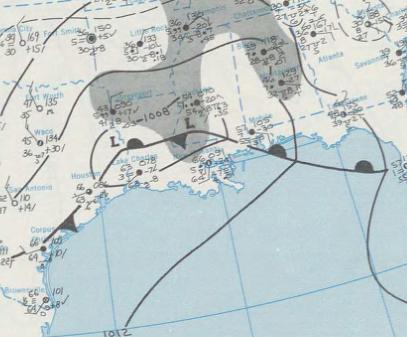
 Map of the developing low pressure system north of the Gulf of Mexico on December 25
Meteorological history
The nor'easter originated in a weak area of surface low pressure that formed over northern Texas by December 25. It moved nominally eastward throughout the day, crossing the southern Gulf Coast states.[5] A southerly low-level jet, a localized stream of air in the lower levels of the atmosphere, developed by midday over Mississippi and Alabama and drifted eastward. At the same time, precipitation began to spread over the southeastern states. The low turned northeast by early on December 26 as a result of the coastal front along the East Coast, at which time the storm underwent its first of two periods of rapid intensification. Barometric pressure fell 12 hPa (0.35 inHg) in 12 hours as the nor'easter accelerated from Georgia to the coast of New Jersey.[4] As the cyclone deepened, the associated trough at the 500-millibar level – several miles into the atmosphere – matured and assumed a negative tilt from northwest to southeast.[1] Precipitation reached New England in its entirety by 0000 UTC on December 27.[5] The low-level jet intensified to an extremely high 55 m/s (120 mph) as it began to wrap around the low from the south, enhancing moisture and warm air under areas of heavy precipitation.[1]
Coupled with the storm's close proximity to the coast, the location of the high pressure area allowed warm air to enter the region and create a changeover to rain in some of the major northeastern cities and southern New England. Parts of the region experienced a severe ice storm as a frontal boundary established itself between warm ocean air and a wedge of cold air over interior New England. Upon reaching New Jersey on December 26, the storm center slowed drastically and remained steady in intensity. While located just east of Long Island on December 27, the nor'easter began its second phase of rapid strengthening and attained its peak intensity as it approached the Massachusetts coast. Minimum pressure fell to 976 hPa (28.8 inHg) as snowfall propagated around the western end of the cyclone, reaching as far south as Long Island. The storm moved slowly northeastward over the next 24 hours, its delayed movement leading to heavy snowfall in Upstate New York and Vermont.[4]
Impact and aftermath
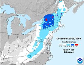 Snowfall map from NCDC
In the storm's developing stages, high winds left at least 50,000 electric customers in the Richmond, Virginia region without power. In Carroll County, bitter winds uprooted trees. Severe thunderstorms extended on the southern edge of the nor'easter, where, in Quincy, Florida, a tornado touched down and caused $100,000 (1969 USD) in damage. The tornado struck an industrial area and ripped the roofs off at least three structures. The storm shut down several major airports along the Northeastern U.S. corridor, including Logan International Airport in Boston and LaGuardia Airport in New York City.[6]
The cyclone was rated by meteorology researchers Kocin and Uccellini (2004) as a high-end Category 3 on the Northeast Snowfall Impact Scale (NESIS), equating to a "major" winter storm.[4] However, more recent data from the National Climatic Data Center (NCDC) classifies the nor'easter as a low-end "crippling" Category 4.[2] Snow accumulated from the Appalachian Mountains from northern Tennessee and North Carolina through western Maine, encompassing the entire Mid-Atlantic region. The highest totals were found inland from the coast. Areas of northeastern Pennsylvania, eastern New York and Vermont reported snowfall in excess of 20 in (51 cm), including 29.8 in (760 mm) at Burlington, 26.4 in (67 cm) at Albany, and 21.9 in (56 cm) at Binghamton, New York. Cities as far south as Washington, D.C. picked up over 1 foot of snow. The nor'easter is one of the most significant snowstorms on record in Upstate New York,[4] with localized pockets of 40 inches.[7] Combined with another snowstorm several days earlier, drifts reached up to 30 feet in height.[8] The storm additionally contributed to monthly snowfall records in the region. In Albany, the December 1969 total snowfall surpassed the former record by 17 in (43 cm),[9] and still stands as of the winter of the 2010–2011.[10]
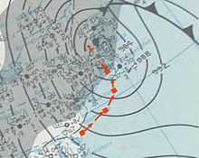 Map of the nor'easter on December 27 over eastern New England
In the Capital District region of New York, the snow fell with a high water content, occasionally mixing with freezing rain. As a result, it was much denser than normal and difficult to clear. Some roads were reportedly not cleared for up to a month, and a record at the time of $2 million USD was spent on snow removal.[11] Albany mayor Erastus Corning 2nd assessed the situation as a "dire emergency",[12] and the city restricted nearly all traffic except for vehicles necessary to maintain emergency supplies. High snow drifts isolated some communities by blocking roadways, leaving residents stranded; in response, thousands of rescue workers searched by snowmobile and aircraft for marooned victims. Governor Nelson Rockefeller let 17,000 state government employees stay home to reduce traffic issues following the storm.[13]
Throughout the region, the weight of the snow, combined with gale-force winds, collapsed roofs and brought down power lines.[14] The storm held the record for the highest single snow total in Burlington until January 2010.[15] Governor Deane C. Davis declared a state of emergency and ordered the National Guard to assist with cleanup efforts.[16] Blowing snow continuously blocked roads after being cleared, and snow removal vehicles, not equipped to withstand the excessive snow, began experiencing mechanical issues. The storm left some communities without power or telephone service for up to two days, although isolated outages persisted longer. Dairy farmers in the state were unable to be reached by tankers to pick up milk, in some cases forcing them to dump it. In other cases, power outages rendered equipment useless, requiring milking to be done manually.[13]
The changeover to rain in central and southern New England swelled frozen rivers, creating ice jams which induced severe flooding. Floodwaters forced hundreds of families to evacuate their residences in Massachusetts, New Hampshire and Maine. As much as 4 in (100 mm) of liquid precipitation fell in the Boston region, where thousands of homes were inundated. Rivers had begun to recede by December 29 after cresting well above flood stage.[16][17] By December 30, at least 20 overall deaths had been attributed to the storm, largely due to traffic accidents and physical strain while clearing snow.[13]
See also
- List of extreme weather events
- Climate of the United States
- List of NESIS storms
References
- ^ a b c d Kocin and Uccellini, p. 473
- ^ a b National Climatic Data Center. "The Northeast Snowfall Impact Scale (NESIS)". National Oceanic and Atmospheric Administration. http://www.ncdc.noaa.gov/snow-and-ice/nesis.php. Retrieved January 7, 2011.
- ^ Climate Prediction Center. "Observation of Monthly Mean North Atlantic Oscillation". National Oceanic and Atmospheric Administration. http://www.cpc.ncep.noaa.gov/products/precip/CWlink/pna/month_nao_index.shtml. Retrieved January 7, 2010.
- ^ a b c d e Kocin and Uccellini, p. 467
- ^ a b Kocin and Uccellini, p. 469
- ^ Associated Press (December 26, 1969). "Snow Piles Quickly in Coast Area". Youngstown Vindicator. http://news.google.com/newspapers?id=rEpJAAAAIBAJ&sjid=Z4QMAAAAIBAJ&dq=maryland%20snow&pg=665%2C3741045. Retrieved March 10, 2011.
- ^ Kocin and Uccellini, p. 468
- ^ Lesley-Ann Dupigny-Giroux (2002). "Climate Variability and Socioeconomic Consequences of Vermont’s Natural Hazards: A Historical Perspective". Vermont Historical Society. http://www.vthistory.org/journal/70/vt701_204.pdf. Retrieved January 7, 2010.
- ^ Julian W. Posey (March 1970). "The Weather and Circulation of December 1969". Monthly Weather Review (American Meteorological Society) 98 (3): 253. Bibcode 1970MWRv...98..253P. doi:10.1175/1520-0493(1970)098<0253:TWACOD>2.3.CO;2. http://docs.lib.noaa.gov/rescue/mwr/098/mwr-098-03-0253.pdf. Retrieved January 7, 2011.
- ^ "Greatest and Least Monthly Snowfalls At Albany, NY (1795-Present)". WRGB Albany. http://www.cbs6albany.com/sections/weather/historical/snowfall/snowfall_top10_years.html. Retrieved March 10, 2011.
- ^ National Weather Service Albany, New York. "Major Winter Storms". National Oceanic and Atmospheric Administration. http://www.erh.noaa.gov/aly/Past/WINTER.htm. Retrieved January 7, 2010.
- ^ Bill Kovachs (December 30, 1969). "Albany Calls 'Dire' Emergency As 26-Inch Snow Paralyzes Area; Albany Declares 'Dire Emergency' After 26-Inch Snowstorm". The New York Times. http://select.nytimes.com/gst/abstract.html?res=FA0F17FF38581B7493C2AA1789D95F4D8685F9. Retrieved January 7, 2011.
- ^ a b c Associated Press (December 30, 1969). "Northeast Stays Paralyzed By Storm". The Lewiston Morning Tribune. http://news.google.com/newspapers?id=AZJfAAAAIBAJ&sjid=7TAMAAAAIBAJ&pg=3083,5879267&dq=snow+albany&hl=en. Retrieved January 7, 2011.
- ^ Staff Writer (December 28, 1969). "New England Clogged by 2-Day Snow". The Chicago Tribune. http://pqasb.pqarchiver.com/chicagotribune/access/631921492.html?dids=631921492:631921492&FMT=ABS&FMTS=ABS:AI&type=historic&date=Dec+28%2C+1969&author=&pub=Chicago+Tribune&desc=NEW+ENGLAND+CLOGGED+BY+2-DAY+SNOW&pqatl=google. Retrieved January 7, 2011.
- ^ Burlington, VT National Weather Service. "Top twenty greatest snowstorms". National Weather Service. http://www.erh.noaa.gov/btv/climo/BTV/extremes/top20snow.shtml. Retrieved March 10, 2011.
- ^ a b Associated Press (December 29, 1969). "4-Foot Snow, Flood Strangle Northeast". The Modesto Bee. http://news.google.com/newspapers?id=xdYwAAAAIBAJ&sjid=w-AFAAAAIBAJ&pg=1681,6731135&dq=snow+albany&hl=en. Retrieved January 7, 2011.
- ^ Associated Press (December 29, 1969). "Vermont Declared a Disaster Area". The Meriden Journal. http://news.google.com/newspapers?id=rcZHAAAAIBAJ&sjid=PP8MAAAAIBAJ&pg=803,8248600&dq=vermont+ice-storm&hl=en. Retrieved January 7, 2011.
- Paul J. Kocin and Louis W. Uccellini (2004). Northeast Snowstorms. American Meteorological Society. ISBN 1-878220-64-0.
External links
Categories:- Nor'easters
- 1969 meteorology
- Natural disasters in New York
- Natural disasters in Vermont


Wikimedia Foundation. 2010.