- Cold air damming
-
Cold air damming, or CAD, is a meteorological phenomenon that involves a high pressure system interacting with local geographic features. A cold-air damming situation typically involves a high pressure system located poleward of a mountain range. This allows for the spin of the high pressure to bring cold air in from the poleward direction and funnel it down a narrow stretch of land in front of the mountains.
Contents
Location
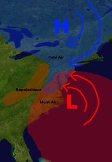 The high pressure in Canada surges the air southward into the oncoming storm system, creating the potential for heavy wintry precipitation anywhere the cold and moist air masses meet.
Cold air damming typically happens in the mid-latitudes of the northern hemisphere, as this region is typically the southernmost limit of the northern jet stream. Cold air damming is not widely observed in the southern hemisphere because of the lack of an appropriate arrangement of a mountain range in relation to the anticyclonic spin of the high pressure system. Some of the most common instances of cold air damming take place on the coastal plain of east-central North America, between the Appalachian Mountains and Atlantic Ocean. A typical situation here involves a high pressure area located in eastern Canada or over northern New England that pulls cold air from the region around Hudson Bay or northern Quebec and pushes it down the eastern side of the mountains, affecting the states from New York to Georgia, and sometimes even as far south as Alabama. Analogous situations can occur alongside the Rocky Mountains over the western portions of the Great Plains and various other mountain ranges (such as the Cascades) along the west coast of the United States.[1]
Effects
When cold air damming occurs, it allows for cold air to surge toward the equator in the affected area. In calm, non-stormy situations, the cold air will advance unhindered until the high pressure area can no longer exert any influence because of a lack of size or its leaving the area.
The effects of cold air damming become more prominent (and also more complicated) when a storm system interacts with the spreading cold air. This interaction is most noticeable on the East Coast of the United States, as the combination of cold air damming and a moist low pressure system is the most important component of a major winter storm. Depending on the strength of the cold air damming, the precipitation types and amounts can vary greatly across the affected region.
The effects of cold air damming east of the Cascades in Washington are strengthened by the bowl or basin-like topography of Eastern Washington. Cold Arctic air flowing south from British Columbia through the Okanogan River valley becomes fills the basin, blocked to the south by the Blue Mountains. Cold air damming causes the cold air to bank up along the eastern Cascade slopes, especially into the lower passes, such as Snoqualmie Pass and Stevens Pass. Milder, Pacific-influenced air moving east over the Cascades is often forced aloft by the cold air in the passes, held in place by cold air damming east of the Cascades. As a result, the passes often receive more snow than higher areas in the Cascades, which supports skiing at Snoqualmie and Stevens passes.[2]
Situations
Cold air damming can produce a number of different atmospheric profiles, and therefore its effects can vary greatly. The majority of the effects are in terms of the precipitation type, though some effect on the precipitation amount are noticeable as well.
The Wedge
The effect known as "the wedge" is the most widely known example of cold air damming. In this scenario, the southern storm system will bring warmer air with it above the surface (at around 1500 meters). This warmer air will ride over the cooler air at the surface, which is being held in place by the high pressure system to the north. This temperature profile will lead to the development of freezing rain or sleet[disambiguation needed
 ], depending on the exact depths of the warm and cold layers. A thinner cold layer will lead to conditions favoring freezing rain, whereas a thicker or stronger cold layer will lead to sleet.
Seeping
While not as well known as the wedge, seeping is another occurrence in a dammed situation. Seeping occurs when the southern storm system develops or begins to move northward before the high pressure serving as the cold air damming mechanism has time to fully establish the dam. In this instance, cold air will seep southward along the surface, causing areas of rain to turn towards freezing rain, sleet, and, in situations that are strong enough or long enough, the precipitation can turn entirely to snow.
Blocking
Blocking occurs when the northern high pressure system is very well established and is lying near or in the path of the advancing storm system. The blocking high pressure will funnel cold air down towards the oncoming storm as well as slow the storm's progress. If the high pressure is strong enough, it can even cause the storm to stall for a short period of time. Blocking situations can involve the presence of a wedge, though this is uncommon because of the typical strength and depth of the cold air the blocking high has put in place.
Blocking situations serve to effect precipitation amounts, and, by stalling storm systems, can greatly increase the storm's total precipitation over affected areas.
Historical Examples
- Northeastern United States Blizzard of 1978
- North American blizzard of 2003
- North American blizzard of 2006
References
- ^ Ron Miller (2000-12-14). "Cold Air Damming Along the Cascade East Slopes". http://www.wrh.noaa.gov/otx/cases/14Dec2000/14Dec2000.php. Retrieved 2007-02-17.
- ^ Mass, Cliff (2008). The Weather of the Pacific Northwest. University of Washington Press. pp. 66–70. ISBN 9780295988474.
Categories:- Synoptic meteorology and weather
- Mesoscale meteorology

Wikimedia Foundation. 2010.