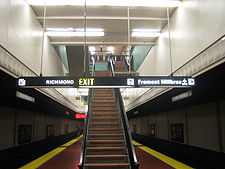
- North Berkeley (BART station)
-
North Berkeley Station
Rapid transit
Station platformStation statistics Address 1750 Sacramento Street
Berkeley, CA 94702Lines Richmond – MillbraeConnections AC Transit:
Eastshore Charter Lines:
At station: Routes 604 and 688 (school days only)
On Sacramento Street: Route 52 (local)
At University Avenue and Sacramento Street: Routes 51B, 88 (local); 800 (All Nighter); FS, J (Transbay)
Free Racetrack Shuttle[1]Platforms Island Parking 822 spaces- Monthly Reserved, Daily ($1/day), Midday (free after 3pm), Extended Weekend (free), Long Term/Airport Permit ($5)[2] Bicycle facilities 58 Lockers Other information Opened January 29, 1973 Accessible 
Owned by Bay Area Rapid Transit Traffic Passengers (FY 2010) 3,817 exits/day[3]  5.03%
5.03%Services Preceding station Bay Area Rapid Transit Following station toward RichmondRichmond – Millbrae toward MillbraeRichmond – Fremont toward FremontNorth Berkeley is an underground Bay Area Rapid Transit station located on Sacramento Street in Berkeley, California. The station is bounded by Virginia, Sacramento, Delaware, and Acton Streets to the north, east, south, and west, respectively.
Contents
Station
The main station entrance sits within a circular building at the center of a parking lot, while an elevator between the surface and the platform is located at the parking lot's Sacramento Street edge. (The elevator has a dedicated turnstile; however, an Addfare machine, which is used to add funds to an already-printed BART ticket, is only available inside the main station entrance.)
History
Service at this station began on January 29, 1973.[4] This station is in BART District 3 and is represented by Bob Franklin.[5]
See also
References
- ^ Eastshore Charter Lines Shuttle Schedule, Golden Gate Fields website, access date 24-02-2009
- ^ http://www.bart.gov/stations/nbrk/index.aspx
- ^ "BART Fiscal Year Weekday Average Exits". Bay Area Rapid Transit (BART). http://www.bart.gov/docs/WeekdayExits.pdf. Retrieved 28 July 2010.
- ^ [1]
- ^ Bay Area Rapid Transit District Biography, BART.gov, retrieved January 23, 2008
External links
Coordinates: 37°52′26″N 122°16′57″W / 37.873915°N 122.282552°W
Bay Area Rapid Transit (BART) Italics denote future stations and date of planned openingCurrent lines Richmond–Millbrae • Fremont–Daly City • Richmond–Fremont • Pittsburg/Bay Point–SFO/Millbrae • Dublin/Pleasanton–Daly City • AirBART
Stations 19th Street/Oakland • Coliseum/Oakland Airport (OAK) • Fruitvale • Lake Merritt • MacArthur • Oakland City Center/12th Street • Rockridge • West Oakland • Oakland International Airport (Under construction) - Doolittle Drive (Planned)Alameda County
(outside Oakland)Ashby • Bay Fair • Castro Valley • Downtown Berkeley • Dublin/Pleasanton • Fremont • Hayward • North Berkeley • San Leandro • South Hayward • Union City • West Dublin/Pleasanton • Warm Springs (2014) • Planned: Livermore • Vasco Road • Irvington (2015)Antioch (2015) • Concord • El Cerrito del Norte • El Cerrito Plaza • Lafayette • North Concord/Martinez • Orinda • Pittsburg (2015) • Pittsburg/Bay Point • Pleasant Hill/Contra Costa Centre • Richmond • Walnut CreekColma • Daly City • Millbrae • San Bruno • San Francisco International Airport (SFO) • South San FranciscoBerryessa (2018) • Milpitas (2018) - Planned: Calaveras – Alum Rock • Downtown San Jose • Diridon/Arena • Santa ClaraSystem features Transbay Tube • Market Street Subway • Berkeley Hills Tunnel • Silicon Valley Extension • SFO extension • Pittsburg/Bay Point extension • Dublin/Pleasanton extension • Original System • Livermore extension • Warm Springs extension • Antioch extension • Oakland Airport extension • Infill stations • Berryessa extensionConnecting bus services AC Transit • Amtrak Thruway Bus Services • Bear • Benicia Breeze • County Connection • Dumbarton Express • Eastshore Charter Lines • East Bay Paratransit • Emery Go Round • Fairfield/Suisun • Golden Gate • Greyhound • Kaiser Shuttle • MAX • Delta Breeze • Muni • SamTrans • Links • San Joaquin RTD • Solano Express• Tri-Delta • Union City • VTA • Vallejo • Napa Vine • WestCAT • WHEELSConnecting rail services Board of Directors District 1: Gail Murray • District 2: Joel Keller • District 3: Bob Franklin (President) • District 4: Robert Raburn • District 5: John McPartland • District 6: Thomas Blalock • District 7: Lynette Sweet • District 8: James Fang • District 9: Tom RadulovichMiscellaneous Library-A-Go-Go • BART history • BART expansion • BART Police • Bay Area Rapid Transit DistrictBerkeley, California Neighborhoods Berkeley Marina · Claremont · Cragmont · Downtown Berkeley · Elmwood · Gourmet Ghetto · La Loma Park · Lorin District · Northside · Panoramic Hill · South Berkeley · Southside · Thousand Oaks · West Berkeley · Westbrae
Education Trunk roads and highways Public transportation AC Transit · Ashby BART · Bear Transit · Berkeley Amtrak Station · Downtown Berkeley BART · North Berkeley BART
People This article relating to rapid transit systems in San Francisco is a stub. You can help Wikipedia by expanding it.
