- Devil's Punch Bowl (Hamilton, Ontario)
-
Devil's Punch Bowl 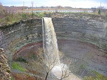
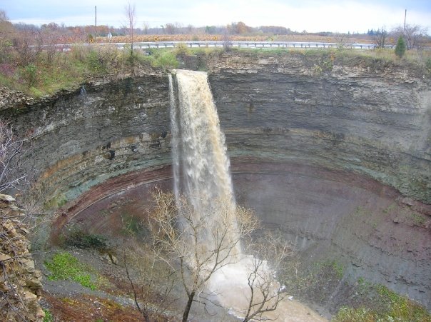
Devil's Punch BowlLocation Hamilton, Ontario Coordinates 43°12′37″N 79°45′21″W / 43.2104°N 79.7558°WCoordinates: 43°12′37″N 79°45′21″W / 43.2104°N 79.7558°W Type Ribbon waterfall Total height 37 m (121 ft) Number of drops Total width 11 m (36 ft) Watercourse Stoney Creek Devil's Punch Bowl is a 37 metre ribbon waterfall on the Niagara Escarpment, in the Stoney Creek community of Hamilton, Ontario, Canada. It is found in the Devil's Punchbowl Conservation Area,[1] maintained by the Hamilton Conservation Authority,[2] and features an escarpment access trail with connections to a recently improved section of the Bruce Trail. Stoney Creek's Dofasco 2000 Trail is nearby.[2] The Punch Bowl is also known as Horseshoe Falls for the distinctive shape of the cliff-face, in which somewhat resembles its much larger cousin.
In addition to the 800 km-long Bruce Trail, nearby attractions include the historic Battlefield House Museum and Nash-Jackson House; on Lake Ontario, Fifty Point Conservation Area and Confederation Park; and Mohawk Sports Park and the Hamilton Museum of Steam & Technology in the city proper. There's also a convenience store, restaurant, motel, gas station and retail stores nearby.[3]
Lower Punch Bowl Falls is a curtain waterfall located a few metres north of the Punch Bowl, spanning 7 metres in height and width.
Contents
History
The history of the Devil’s Punchbowl dates back to over 450 million years ago. It was formed throughout the years by many glacial waters; it withholds different layers of colorful stratified rock segments. The falls drops about 108.25 feet. Another monument that is considered part of the Devil’s Punchbowl is the ten-meter high cross that overlooks the Stoney Creek community and Hamilton Harbor. This cross was made in December 18, 1966 in memory of a priest named William Sinclair (1925-1994)[4] . He built the cross to bring light to the community. Originally the cross was only planned on being lit up during Christmas and Easter for six weeks. However, with the help of the donations from the Knights of Columbus the cross lights up automatically every night. There are numerous stories surrounding in how Devil’s Punchbowl got its name, some believe that individuals that God would not want his creation named after him instead, he named it after the “devil.” Another assumption states that moonshiners set up their wares on the road leading up to the Punchbowl, when the workers got thirsty they would go up to the falls to get some cold water[5] . The moonshiners were viewed as individuals that did “devil’s work” giving the monument its current name today.
Geology and Geography
The Devil’s Punch Bowl originated 450 million years ago when materials that form the Niagara escarpment were originally deposited in an inland sea. Corals and other organisms that lived in the area became fossilized as the sea bottom deposits changed into rocks [6].
The formation of the Devil’s Punch Bowl occurred 1 million years ago after one of the four great ice ages. As the ice slabs that covered the area melted at the end of the ice age, high levels of water occurred. These streams of fast moving waters carved out the land and formed what would become the Devil’s Punch Bowl [6]. Formation of the Devil’s Punch Bowl has declined since its original formation; it often dries up or is only a trickle. However, stream still picks up during rain and as snow is melting. The site also has two distinct waterfalls in the upper and lower regions.[7]
Today it has become a famous landmark amongst geologists worldwide because of its exposed rock strata [6]. The stratigraphy of the Punch Bowl has been studied by geologists, including McMaster University students.[8]
From the top of the escarpment a beautiful view of various locations can be seen such as; East Hamilton, Burlington, Stoney Creek and weather permitting, the Toronto sky line can become visible as well.[9]
Entertainment
The Devils Punch Bowl has been an ideal spot for various movies, television shows, and attractions. In the movie Silent Hill directed by Christophe Gans in 2006 the movie opens to a young girl trying to jump of a cliff into a dark world of “fire and metal”. This cliff was the edge of the actual Devil’s Punch Bowl overlooking the waterfall and rock bottom below. Her mother then saves her from jumping and the director cuts to a clip of them beside the falls with the “Keeper of the Cross” image in the background of the scene[10]. In the blockbuster cinema, The Big Hit (1998), scenes from the area are shown that highlight the beautiful waterfall, and the surrounding area [11] .In 1989 Super Dave Osborne performed a yo-yo stunt at the Devil’s Punch Bowl that had his fans taking about the stunt for weeks [12] .
See also
References
- ^ "Hamilton - Waterfall Capital of the World". (www.cityofwaterfalls.ca). http://www.cityofwaterfalls.ca/. Retrieved 2008-07-12.
- ^ a b "Hamilton Conservation Authority: Passive Areas". http://www.conservationhamilton.ca/area-information/conservation-areas/area-information/passive-areas. Retrieved 2010-10-25.
- ^ Hamilton Waterfalls and Cascades: Research & Inventory Report, 2nd Edition. Hamilton Conservation Authority. November 2007.
- ^ Brady, George, Cathy. "Devil's Punchbowl A brief history". http://hamiltonparanormal.com/punchbowl.html. Retrieved November, 1/2011.
- ^ D, Adrian. [Devil's Punchbowl "Devil's Punchbowl"]. Devil's Punchbowl. Retrieved November, 1/2011.
- ^ a b c "Devil's Punch Bowl". Haunted Hamilton. http://www.ghostwalks.com/local_punchbowl.html. Retrieved 3 November 2011.
- ^ "Devil's Punch Bowl - Virtual Field Trip". McMaster University. http://www.science.mcmaster.ca/geo/outreach/road_trips/Devil's_Punchbowl.pdf.
- ^ "Devil's Punch Bowl - Virtual Field Trip". McMaster University. http://www.science.mcmaster.ca/geo/outreach/road_trips/Devil's_Punchbowl.pdf.
- ^ "Devil's Punch Bowl - Virtual Field Trip". McMaster University. http://www.science.mcmaster.ca/geo/outreach/road_trips/Devil's_Punchbowl.pdf.
- ^ "Silent Hill". IMDB. http://www.imdb.com/title/tt0384537/..
- ^ "Scenic Lake Ontario, marinas and affordable beach houses - llittle wonder commuters are heading for Stoney Creek". http://www.mynewwaterfronthome.com/Community/98/stoneycreek.aspx..
- ^ "Devil's Punchbowl". http://www.cityofwaterfalls.ca/devil_punchbowl.html.
External links
Hamilton, Ontario Features Flag · Notable HamiltoniansHistory 1930 British Empire Games · Auchmar · Bank of Hamilton · Battlefield House · Battle of Stoney Creek · Dundurn Castle · George Hamilton · Grand Lodge of Canada · Hamilton Tigers (NHL) · HMCS Haida · List of royal visits · Studebaker Canada Ltd. · Tim Hortons · Thomas McQuesten · Timeline of events · Toronto, Hamilton and Buffalo Railway · USS Hamilton · USS Scourge · War of 1812 · WhitehernGeography 100+ waterfalls of Hamilton · Bruce Trail · Cootes Paradise · Desjardins Canal · Golden Horseshoe · Hamilton Harbour · Lake Ontario · List of neighbourhoods in Hamilton · Niagara escarpment · Royal Botanical Gardens · Spencer Gorge / Webster's Falls Conservation AreaPlaces in Hamilton Economy Arcelor Mittal / Dofasco · Economic history · Film industry in Hamilton · Hamilton Health Sciences · Head offices in Hamilton · List of tallest buildings in Hamilton · U.S. Steel / StelcoPolitics Public services Hospitals Chedoke Hospital · Hamilton General Hospital · Juravinski Cancer Centre · Juravinski Hospital · McMaster Children's Hospital · McMaster University Medical Centre · St. Joseph's Healthcare Hamilton · St. Peter's HospitalEducation Hamilton Public Library · Hamilton-Wentworth Catholic District School Board · Hamilton-Wentworth District School Board · Hillfield Strathallan College · Columbia International College · McMaster Divinity College · McMaster University · Mohawk College · Redeemer University College · Hamilton Literacy CouncilCulture African Lion Safari · Around the Bay Road Race · Art Gallery of Hamilton · Canadian Football Hall of Fame · Canadian Warplane Heritage Museum · Dundas Cactus Festival · Hamilton Bulldogs · Hamilton Tiger-Cats · Labour Day Classic · List of Attractions in Hamilton · Media in Hamilton · Power Play (TV series) · Sports in Hamilton · Sports venues in HamiltonTransportation Categories:- Waterfalls of Hamilton, Ontario
- Golden Horseshoe geography stubs
Wikimedia Foundation. 2010.