- Mandrayal
-
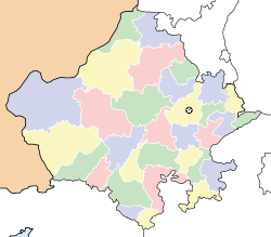
Mandrayal — city — Coordinates 26°18′N 77°14′E / 26.3°N 77.23°ECoordinates: 26°18′N 77°14′E / 26.3°N 77.23°E Country India State Rajasthan District(s) Karauli Population 23,118 (2001[update]) Time zone IST (UTC+05:30) Area
• 262 metres (860 ft)
Mandrayal ( मंडरायल ) is a town in the state of Rajasthan, India, with a population of 23,000. It is also known as Mndrail or Mandrael. The nearest towns are Sabalgarh, Karauli. The language spoken is Hindi.
Contents
History
Mandrayal is the main town in the Karauli district. It is most famous for joining the two states of Madhya Pradesh and Rajasthan and also regarding its history. Puranmal, the Raja of Amber fought in the battle called the Battle of Mandrayal in favour of Mughals. This was in the year 1534. Next year, Bahadur Shah of Gujrat besieged the fort of Chittoor, upon which Humayun himself started to fight against him. Rani Karmawati the widow of Rana Sanga was ruling Chittor as regent. She also tried to be friendly with Mughals and sent a Rakhi to Humayun, but Humayun did not arrive in time. If he had arrived in time and helped Karmawati, perhaps it would have been Sisodias as their close allies. However it were Kachwahas who became the first allies of Mughals in Rajputana. Bharmal's policy towards Mughals was merely extension of his brothers policy.
Bharmal's eldest brother Raja Puranmal died at the Battle of Mandrayal in 1534, while helping Humayun to recapture the fort of Bayana. He had a son named Surajmal or Sooja. But he was not recognised as king and his younger brother Raja Bhim Singh asceneded to the throne of Amber. Bhim Singh was succeeded by his son Raja Ratan Singh and Raja Bharmal succeeded him in 1548, CE.
Festivals
The main religious festivals are Deepawali, Holi, Gangaur, Teej, Gogaji, Makar Sankranti and Janmashtami, as the main religion is Hinduism. Rajasthan's desert festival is celebrated with great zest and zeal. This festival is held once a year during winters. Dressed in brilliantly hued costumes, the people of the desert dance and sing haunting ballads of valor, romance and tragedy. There are fairs with snake charmers, puppeteers, acrobats and folk performers. Camels, of course, play a stellar role in this festival.
Distances of places
- Karauli:40 km
- Kota: 270 km
- Gwalior:150 km
- Jaipur: 190 km.
- Sawai Madhopur: 146 km
- Agra: 155 km
- Delhi: 360 km
- Sabalgarh: 35 km
The Madhya Pradesh border formed by the Chambal River is 5 km away from Mandrayal.
References
External links
Yahoo Groups : http://groups.yahoo.com/group/mandrayal
Karauli Cities and towns
in other districtsAjmer · Alwar · Banswara · Baran · Barmer · Bharatpur · Bhilwara · Bikaner · Bundi · Chittorgarh · Churu · Dausa · Dholpur · Dungarpur · Hanumangarh · Jaipur · Jaisalmer · Jalore · Jhalawar · Jhunjhunu · Jodhpur · Kota · Nagaur · Pali · Pratapgarh · Rajsamand · Sawai Madhopur · Sikar · Sirohi · Sri Ganganagar · Tonk · Udaipur
State of Rajasthan (India) Major cities 
Divisions Districts Ajmer · Alwar · Banswara · Baran · Barmer · Bharatpur · Bhilwara · Bikaner · Bundi · Chittorgarh · Churu · Dausa · Dholpur · Dungarpur · Hanumangarh · Jaipur · Jaisalmer · Jalore · Jhalawar · Jhunjhunu · Jodhpur · Karauli · Kota · Nagaur · Pali · Pratapgarh · Rajsamand · Sawai Madhopur · Sikar · Sirohi · Sri Ganganagar · Tonk · UdaipurCategories:- Cities and towns in Karauli district
- Indian Princely States
- 1348 establishments
- Karauli district
Wikimedia Foundation. 2010.


