- Cyclone Bola
-
This article is about the cyclone in 1988; for the deadly cyclone in 1970 that struck Bangladesh, see 1970 Bhola cyclone
Tropical Cyclone Bola Category 4 cyclone (Australian scale) Category 3 cyclone (SSHS) 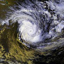
Satellite image of Cyclone Bola near peak intensity Formed February 24, 1988 Dissipated March 4, 1988 Highest winds 10-minute sustained:
165 km/h (105 mph)
1-minute sustained:
195 km/h (120 mph)Lowest pressure 940 mbar (hPa; 27.76 inHg) Fatalities 3 direct Damage $82 million (1988 USD) Areas affected Fiji, Vanuatu, New Zealand Part of the 1987-88 Southern Hemisphere tropical cyclone season Cyclone Bola was one of the costliest cyclones in the history of New Zealand,[1] causing severe damage as an extratropical cyclone when it passed near the country in March 1988. It formed on February 24 to the north of Fiji, and tracking generally southwestward it reached hurricane-force winds near Vanuatu on February 28. The next day it generated peak wind velocities of 195 km/h (120 mph), though it quickly weakened as it accelerated southward. On March 4 Bola transitioned into an extratropical storm, passing to the north of the North Island of New Zealand on March 8. It weakened further and was absorbed by a stationary trough near the South Island on March 12.
The cyclone first affected Fiji, where it produced gale force winds and strong waves. In Vanuatu, Bola dropped heavy rainfall, which destroyed two bridges and caused severe damage to islands in the group. Bola caused severe damage to the North Island of New Zealand, where heavy rainfall peaked at 917 mm (36.1 in) in Gisborne Region. Damage totaled over $82 million (1988 USD, $152 million 2011 USD).[2] Three people were killed due to flooding, and hundreds were evacuated when a swollen river threatened a town. The name Bola was later retired, meaning it will not be used again within the same basin.[3]
Contents
Meteorological history
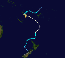 Storm path
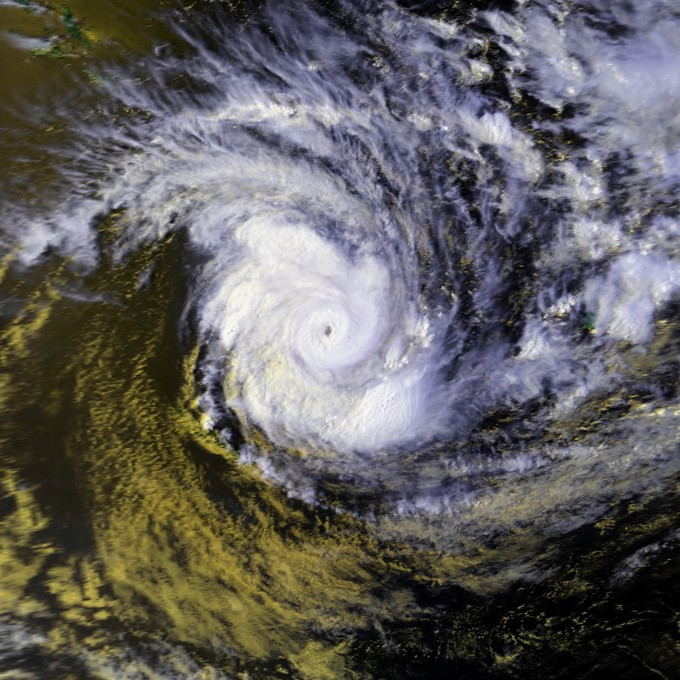
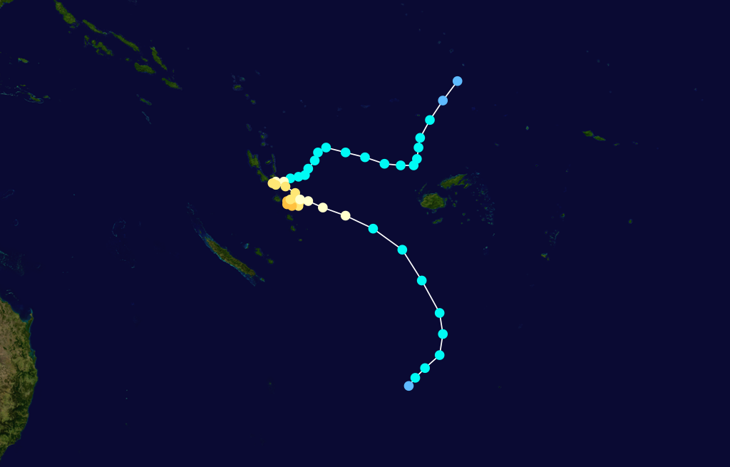
A tropical disturbance began organizing about 870 km (540 mi) north of Fiji on February 23, 1988. It tracked southwestward, intensifying into a tropical storm on 24 February;[4] the system was named Tropical Storm Bola by the Regional Specialized Meteorological Centre in Nadi, Fiji (RSMC Nadi).[3] The storm turned westward on February 25, and to the southwest the next day. Bola gradually intensified as its movement slowed and stalled, and on February 28 the Joint Typhoon Warning Center (JTWC) assessed the cyclone as reaching hurricane-force winds near Vanuatu. It turned to a southeast drift before executing a small cyclonic loop on March 1, during which the JTWC estimated Bola attained peak winds of 195 km/h (120 mph). At the same time, its minimum central pressure was estimated at 940 mbar.[4][5]
After reaching peak intensity, Cyclone Bola quickly weakened as it accelerated southeastward toward a frontal trough.[4][6] On March 3, its winds dropped below hurricane-force,[4] and it gradually lost its tropical characteristics. The structure became asymmetric, with a large band of clouds extending well south of the circulation.[6] By March 4, Bola had completed the transition into an extratropical cyclone.[4] Which turned south and began to affect the North Island of New Zealand on March 6. A building ridge of high pressure to its south caused the extratropical remnants of Bola to slow and turn to the west on March 7. The next day, the storm passed about 110 km (70 mi) north of the North Island. Around the same time, the storm began slowly filling, meaning the low pressure area associated with Bola was losing its identity. It turned southward on March 9, and on March 12 was absorbed by a stationary trough in the Westerlies near the western coast of the South Island.[6]
Impact
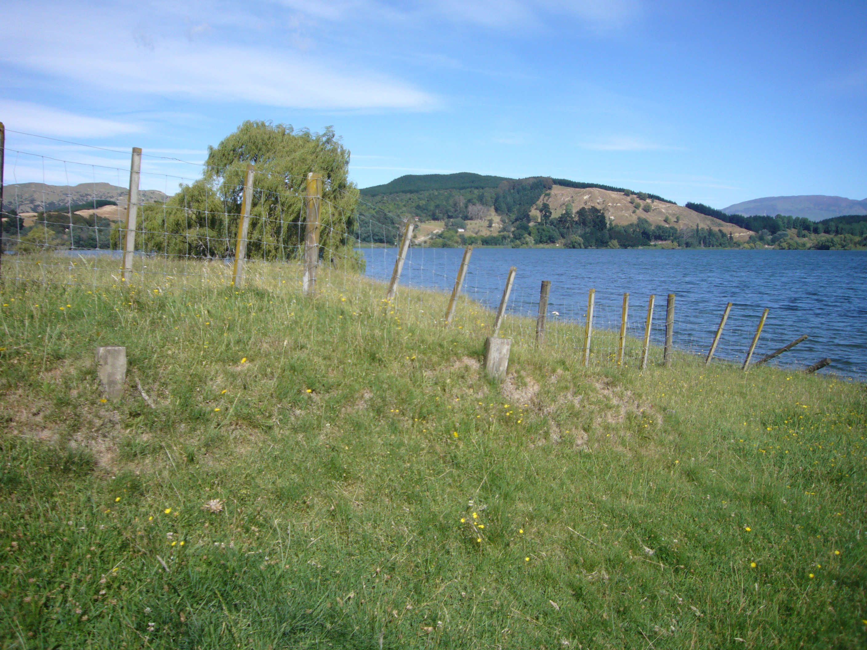
 Fence posted buried alongside Lake Tutira due to erosion caused by Cyclone Bola
Fiji and Vanuatu
As a tropical cyclone, Bola first impacted Fiji shortly after forming while passing to the northwest, and again as it was weakening after peak intensity to the southwest of the island. It brushed the country with gale force winds and waves of up to 5 m (16.4 ft), with severe damage reported throughout the archipelago.[7][8]
Cyclone Bola remained near Vanuatu for about a week,[9] during which it reached its peak intensity while executing a cyclonic loop.[4] The most affected locations were Epi island, the Shepherd Islands, and the islands in Malampa Province, and throughout the country the cyclone affected more than 15,000 people and 3,000 houses.[9] In a five day period the cyclone dropped about 450 mm (17.7 in) of rainfall. Two bridges on Malakula were destroyed, and several other bridges were flooded or damaged. The passage of the cyclone also left several buildings, roads, and crop fields damaged.[10]
New Zealand
Cyclone Bola created some of the heaviest rainfall totals for a single storm in the history of New Zealand, with some locations receiving more than half of their annual rainfall totals from the storm. While the cyclone passed north of the island, a strong easterly flow over the North Island contained the interaction between moist air from Bola and drier air from the ridge to its southeast. In the Gisborne region, the flow resulted in the heaviest rainfall totals, when the moisture ascended over the region's western mountainous areas and condensed into precipitation. One station recorded 419 mm (16.5 in) in a 24 hour period.[6] The maximum rainfall total attributed to the storm was 917 mm (36.1 in), reported at a station near Tolaga Bay.[1] Heavy rainfall totals of up to and over 300 mm (12 in) were observed in the regions of Auckland and Northland.[6] The cyclone is the largest to be recorded in 93 years of rainfall records. As such, it had a large and lasting effect on the rivers of the area when it deposited a large amount of sediment, as recorded in the sedimentary record of Lake Tutira.[11] Shortly prior to losing its identity, the remnants of Bola also dropped 100–200 mm (4–8 in) of precipitation on the South Island of New Zealand.[6]
Storm damage was heaviest in Gisborne, where rain destroyed or damaged several roads and bridges.[6] Three days of continuous rainfall led to mudslides, flooding,[1] and erosion.[2] Flooding killed three people when a car was swept away. In Te Karaka in Gisborne, a flooded river forced 500 residents to evacuate. A total of 1,765 farmers were affected by the flooding, accounting for about 3,600 hectares (8,900 acres) of damaged crop fields and about $90 million in crop damage (1988 NZD, $82 million 1988 USD $152 million 2011 USD). Water supplies were disrupted in two cities due to flooding. Rainfall in Northland Region caused flooding and outages to telephone and power.[1] Additionally, beginning on about 6 March, the cyclone began affecting the North Island with strong easterly winds of over hurricane force, caused by the interaction between the extratropical remnants of Bola and a ridge of high pressure to its south. The winds damaged a few homes, including some in which the roofs were damaged or destroyed.[1][6] In addition, the strong winds downed several trees, and at the same time, erosion and landslides left hillsides bare without grass or trees.[2][6]
Aftermath
In Vanuatu, cyclone victims received food and emergency aid following the storm.[9] Australian patrol boat HMAS Cessnock provided manpower assistance to 11 islands in the country.[12] Reconstruction costs in Vanuatu totalled about $5 million (1988 USD, $9.28 million 2011 USD), which was about 10 percent of the country's national budget.[9]
After the passage of the storm, four towns in New Zealand declared states of emergency.[1] The New Zealand government provided about $80 million (1988 NZD) to the east coast region of the North Island for assisting in cyclone damage. $8 million was used to create an East Coast Forestry Conservation Scheme, which was set to protect forests and prevent erosion.[2] A study was taken five years after the storm, consisting of a group of 112 people who were evacuated or received monetary assistance in response to the cyclone; the study showed 12% of the respondents as experiencing Posttraumatic stress disorder, of which they reported a general lack of assistance and public support.[13]
See also
References
- ^ a b c d e f Christchurch City Library. "New Zealand Disasters: Cyclone Bola". http://library.christchurch.org.nz/kids/nzdisasters/CycloneBola.asp. Retrieved 2008-06-08.
- ^ a b c d Colin L. O'Loughlin (1991). "Priority Setting for Government Investment in Forestry Conservation Schemes-An Example from New Zealand" (PDF). USDA Forest Service. http://www.fs.fed.us/psw/publications/documents/psw_gtr130/psw_gtr130_oloughlin.PDF. Retrieved 2008-06-11.
- ^ a b Tropical Cyclone Programme (2006). "Tropical Cyclone Operational Plan for the South Pacific and Southeast Indian Ocean" (PDF). World Meteorological Organization. http://www.wmo.ch/pages/prog/www/tcp/documents/TCP-24OP-PLN2006edition-english.pdf. Retrieved 2008-06-03.
- ^ a b c d e f Joint Typhoon Warning Center. "1988 Annual Tropical Cyclone Report" (PDF). http://www.usno.navy.mil/NOOC/nmfc-ph/RSS/jtwc/atcr/1988atcr/pdf/1988_complete.pdf. Retrieved 2008-06-03.
- ^ "Cyclone Bola". Bureau of Meteorology (Australia). 2009-04-26. http://www.bom.gov.au/tmp/spacific_ocean1987198711.html. Retrieved 2009-04-26.[dead link]
- ^ a b c d e f g h i Mark R. Sinclair (1993-03-20) (PDF). A Diagnostic Study of the Extratropical Precipitation Resulting from Tropical Cyclone Bola. American Meteorological Society. http://www.webcitation.org/5p7EhNHdG. Retrieved 2010-04-19.
- ^ Stephen F. Barstow and Ola Haug (1994). "Wave Climate of Fiji" (PDF). South Pacific Applied Geoscience Commission. http://www.sopac.org/data/virlib/TR/TR0205.pdf. Retrieved 2008-06-05.[dead link]
- ^ "South Pacific Cluster Evaluation: Cyclone Damage Since 1987". Fiji's National Disaster Management office. Australian Aid. 1998-10-06. pp. 68. http://www.webcitation.org/5p4a0oeai. Retrieved 2010-04-18.
- ^ a b c d Government of Vanuatu (2001). "Programme of Action for the Development of Vanuatu, 2001-2010" (PDF). United Nations. http://www.unctad.org/Templates/Download.asp?docid=1228&lang=1&intItemID=1942. Retrieved 2008-06-05.
- ^ Stan Combs (1995). "Infrastructure Of Malekula". http://members.shaw.ca/scombs/mal_infr.html. Retrieved 2008-06-05.
- ^ M.J. Page; N.A. Trustrum,R.C. Derose (1994). "A high resolution record of storm-induced erosion from lake sediments, New Zealand". Geomorphology 9 (3): 169. doi:10.1007/BF00677993.
- ^ "HMAS Cessnock (II)". Sea Power Centre Australia. 2005. http://www.navy.gov.au/HMAS_Cessnock_(II). Retrieved 2008-09-15.
- ^ Eustace, MacDonald, and Long (1999). "Cyclone Bola : A study of the psychological after-effects". Anxiety, stress, and coping 12 (3): 285–298. doi:10.1080/10615809908250479. ISSN 1061-5806. http://cat.inist.fr/?aModele=afficheN&cpsidt=1957658. Retrieved 2008-06-12.
External links
- World Meteorological Organization
- Fiji Meteorological Service
- Meteorological Service of New Zealand
- Joint Typhoon Warning Center
1970s 1980s 1990s 2000s 2010s Categories:- Retired South Pacific cyclones
- 1988 natural disasters
- 1988 in Fiji
- 1988 in New Zealand
- 1988 in Vanuatu
- Tropical cyclones in New Zealand
- Tropical cyclones in Fiji
- Tropical cyclones in Vanuatu
- Category 4 South Pacific cyclones
Wikimedia Foundation. 2010.