- 1999–00 South Pacific cyclone season
Infobox hurricane season
Basin=SPac
Year=2000
Track=1999-2000 South Pacific cyclone season summary.jpg
First storm formed=January 7, 2000
Last storm dissipated=April 16, 2000
Strongest storm name=Kim
Strongest storm pressure=955
Strongest storm winds=95
Average wind speed=10
Total depressions=
Total storms=
Total hurricanes=6
Total intense=
Fatalities=At least 1 indirect
Da
Inflated=
five seasons=1997–98, 1998–99, 1999–00, 2000–01, 2001–02The 1999-00 South Pacific tropical cyclone season was an event in the annual cycle oftropical cyclone formation and ran from November 1, 1999 to April 30, 2000 in the South Pacific.It should also be noted that the regional tropical cyclone operational plan defines a "tropical cyclone year" separately from a "tropical cyclone season", with the "tropical cyclone year" for this season lasting from July 1, 1999 to June 30, 2000.
All of the six named storms affected land in some way, but no major damage was reported from any of the storms.
__TOC__
torms
Tropical Cyclone Iris
Infobox Hurricane Small
Basin=SPac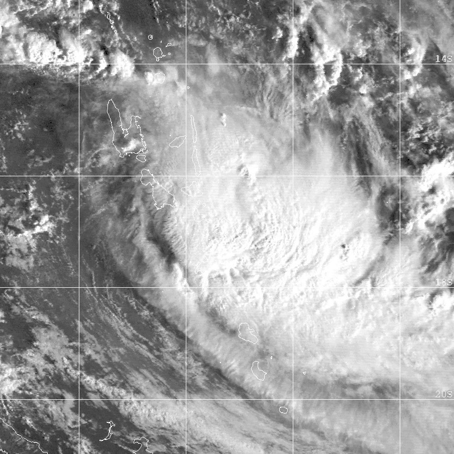
Track=Iris 2000 track.png
Dissipated=January 10
10-min winds=70
1-min winds=70
Pressure=975Vanuatu . The storm was difficult to locate the general centre for the next couple of days, but on 6 January, it became more organised, while displaying midget characteristics. On 7 January at 2100 (UTC), it was named Tropical Cyclone Iris, located 330 km (205 mi) northwest ofPort Vila , moving southeast. In Vila, 110 km (70 mi) away from Iris's centre, recorded winds of only up to convert|20|kn|km/h, explaining the very small size of the cyclone. Iris intensified with 10-min winds increasing to convert|60|kn|km/h on 8 January at 1200 (UTC). JTWC's estimated 1-min winds was convert|65|kn|km/h. There were some indications that Iris could be far more intense than what the warning centres estimated, mainly due to its small size. Iris accelerated eastward, leaving Vanuatu. On 9 January, Iris began its weakening trend, while moving closer toFiji . Iris was downgraded to a depression on 10 January, just 48 hours after it had reached its peak intensity. The final warning placed the centre on the Dateline convert|150|nmi|km|abbr=on southeast of Fiji.Fresh to strong winds and very rough seas were experienced over the western and southern parts of Fiji. Overall damage was minimal. Cyclone Iris was most notable for its rapid strengthening in its early stages, followed by its rapid decay.cite web|author=Gary Padgett|title=MONTHLY GLOBAL TROPICAL CYCLONE SUMMARY - JANUARY, 2000|accessdate=August 7|accessyear=2006|url=http://www.australiansevereweather.com/cyclones/2000/summ0001.htm]
Tropical Cyclone Jo
Infobox Hurricane Small
Basin=SPac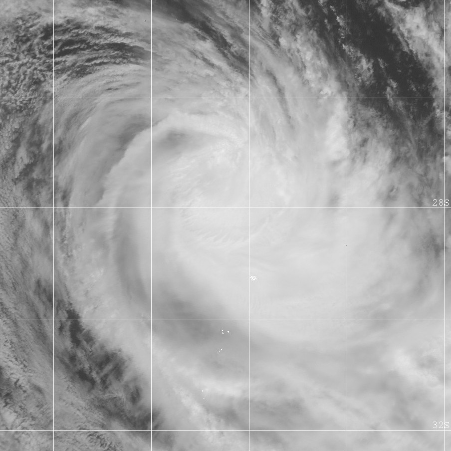
Track=Jo 2000 track.png
Dissipated=January 27
10-min winds=65
1-min winds=65
Pressure=975Vanuatu on 19 January. It developed slowly, but deepened quickly on 22 January, and advisories were issued on the system on 23 January. It moved southward and was upgraded to Tropical Cyclone Jo on 24 January at 0300 (UTC). Jo moved to the south-east and attained storm force winds 15 hours after being named. The cyclone reached its peak intensity on 26 January at 0000 (UTC) located 650 km (400 mi) south ofNadi , with 10-min average winds of convert|60|kn|km/h. JTWC's peak 1-min average winds were convert|65|kn|km/h. Jo moved further to the south-east, and moved close enough to affectFiji . Gusts to convert|50|kn|km/h were recorded onViti Levu on Fiji, even though Jo was about 445 km (275 mi) away from the Fiji. Flash flooding was reported, but there was no major river flooding. Cyclone Jo was declared extratropical on 28 January at 0600 (UTC) when located more than convert|1000|nmi|km|abbr=on east ofNorth Island inNew Zealand .cite web|author=Gary Padgett|title=MONTHLY GLOBAL TROPICAL CYCLONE SUMMARY - JANUARY, 2000|accessdate=August 7|accessyear=2006|url=http://www.australiansevereweather.com/cyclones/2000/summ0001.htm]Tropical Cyclone Kim
Infobox Hurricane Small
Basin=SPac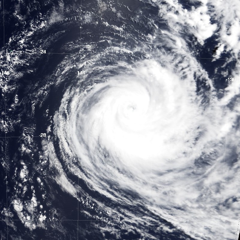
Track=Kim 2000 track.png
Dissipated=February 29
10-min winds=95
1-min winds=100
Pressure=955French Polynesia on February 23, 2000. It initially developed little but late on 24 February, the depression developed rapidly, and the storm reachedtropical storm strength at 1800 (UTC), named Tropical Cyclone Kim. It was located about 75 km (45 mi) west ofRikitea or about 125 km (75 mi) southeast ofMururoa . Cyclone Kim reached hurricane strength on 25 February, only 18 hours after being named, while moving to the south-west. The storm reached its peak intensity of convert|80|kn|km/h on 26 February at 1200 (UTC), located more than 1295 km (805 mi) east ofTahiti . Minimum pressure at this time was 955 mbar. The estimated 1-min average winds from NPMOC was convert|100|kn|km/h. Kim gradually weakened over cooler waters, still moving to the south-west. Cyclone Kim becameextratropical south ofTahiti on February 29 at 0600 (UTC).Damage from Kim was minimal from
Rikitea , since it was only a depression at the time. The island recorded 10-min average winds of convert|27|kn|km/h, with a peak gust of convert|52|kn|km/h and a minimum pressure of 996 mbar. As a hurricane, the island ofRapa recorded a gust of convert|74|kn|km/h, when Kim was 150 km (90 mi) away from the island. A pressure of 995.8 mbar was recorded. Overall, damage inFrench Polynesia was minor.cite web|author=Gary Padgett|title=MONTHLY GLOBAL TROPICAL CYCLONE SUMMARY - FEBRUARY, 2000|accessdate=August 7|accessyear=2006|url=http://www.australiansevereweather.com/cyclones/2000/summ0002.htm]Tropical Cyclone Leo
Infobox Hurricane Small
Basin=SPac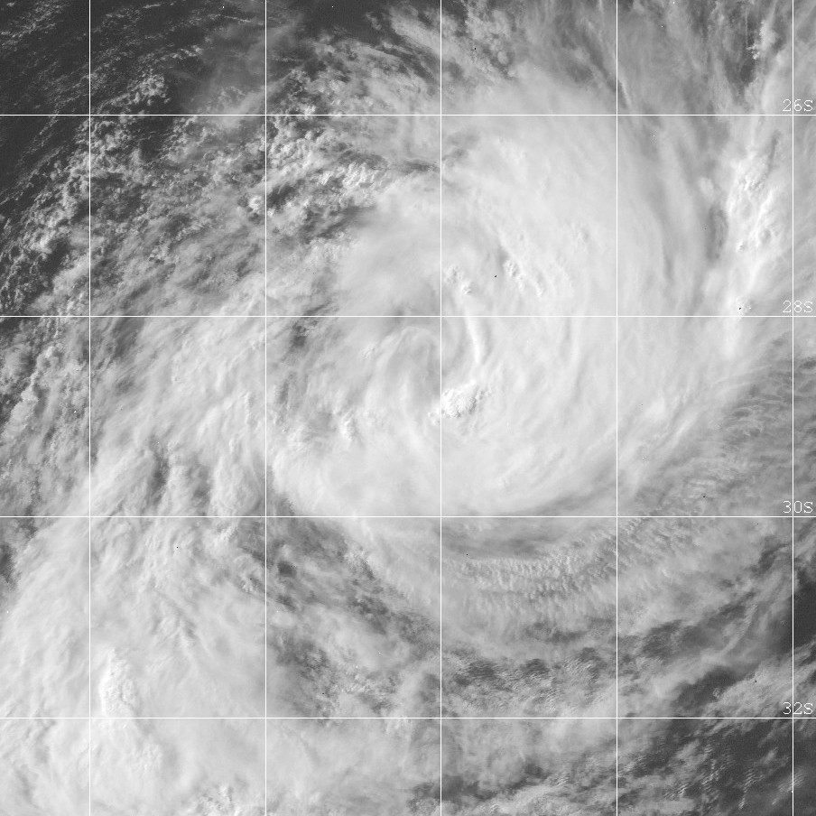
Track=Leo 2000 track.png
Dissipated=March 8
10-min winds=50
1-min winds=55
Pressure=985French Polynesia . The depression drifted south-westward in the next 24 hours. The first gale warning was issued at 0000 UTC on the 5th, located 555 km (345 mi) west-southwest ofTahiti . The depression moved through the southernCook Islands and slowly developed, but suddenly developed explosively on 6 March at 0600 UTC while located nearRarotonga . It was named Leo at 1200 UTC on the 6th. It accelerated to the south-southwest and reached a peak intensity of convert|50|kn|km/h on the 7th at 0000 UTC. After 1800 UTC, Leo recurved to the southeast and became extratropical six hours later. Although, Leo moved over the island ofMangaia , any damage was minor.cite web|author=Gary Padgett|title=MONTHLY GLOBAL TROPICAL CYCLONE SUMMARY - MARCH, 2000|accessdate=August 7|accessyear=2006|url=http://www.australiansevereweather.com/cyclones/2000/summ0003.htm]Tropical Cyclone Mona
Infobox Hurricane Small
Basin=SPac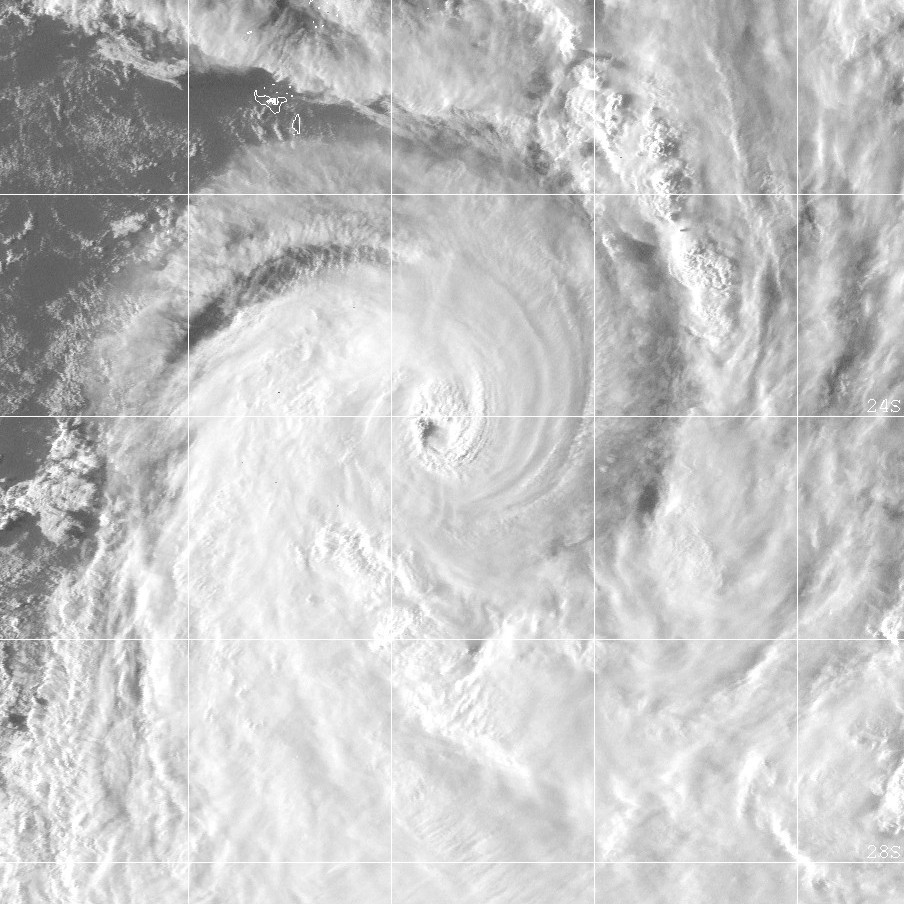
Track=Mona 2000 track.png
Dissipated=March 11
10-min winds=75
1-min winds=80
Pressure=965Apia inWestern Samoa . The first gale warning was issued on 7 March as it moved closer to northernTonga . Wind warnings were issued for some islands in Tonga includingVavau ,Haapai andTongatapu . The storm rapidly developed on 8 March at 0600 UTC, and was named Tropical Cyclone Mona six hours later, while located 75 km (45 mi) west ofHaapai and moving slowly southward. A storm warning was put for the whole Tongatapu Group on the 8th. An eye developed on 9 March, and Mona was upgraded to hurricane intensity at 0600 UTC, located 55 km (35 mi) west ofTongatapu . Mona moved south-southeastward and accelerated. It reached an intensity of convert|75|kn|km/h on 10 March, 370 km (230 mi) southeast of Tongatapu. NPMOC's 1-min winds were estimated at convert|80|kn|km/h. Minimum pressure of Mona was 965 mbar. It began to weaken rapidly, as it sped off southwards, and became extratropical on 11 March at 1200 UTC.In the Vavau and Haapai groups, there was damage to crops, particularly to banana and coconut plantations. There was moderate damage to houses and school buildings in Tongatapu. The unofficial damage assessment, according to the Tongan National Disaster Management Office, totalled Tongan $6 million. A police patrol boat sank off Eua Island in the Tongatapu group.cite web|author=Gary Padgett|title=MONTHLY GLOBAL TROPICAL CYCLONE SUMMARY - MARCH, 2000|accessdate=August 7|accessyear=2006|url=http://www.australiansevereweather.com/cyclones/2000/summ0003.htm]
Tropical Cyclone Neil
Infobox Hurricane Small
Basin=SPac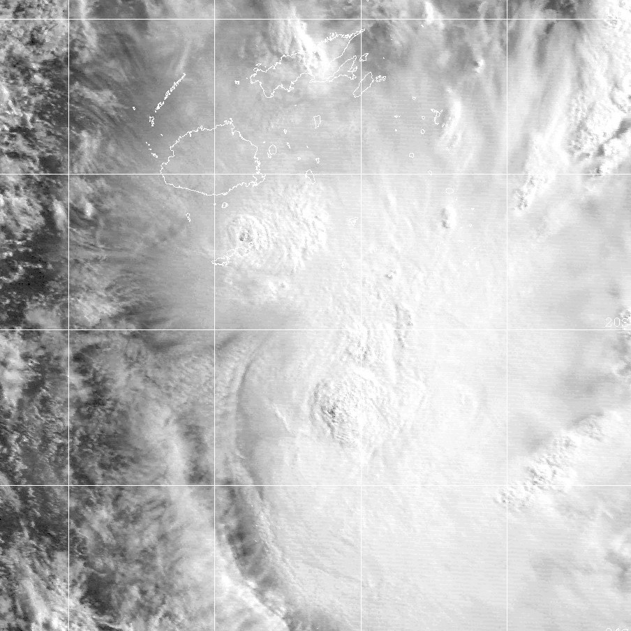
Track=Neil 2000 track.png
Dissipated=April 16
10-min winds=40
1-min winds=40
Pressure=992Fiji on 12 April. It moved to the south-west while continually strengthening. By the 15 April the potential for development to a cyclone was considered "high" by RSMC Nadi. At 1700 UTC, it was named Tropical Cyclone Neil, located 150 km (90 mi) southeast ofKadavu . It moved slowly southward, but on 16 April at 1200 UTC, it was downgraded to a tropical depression.Damage from Neil was minimal.
Kadavu andOno-i-Lau in Fiji reported gales from Neil, while torrential rain was experienced over some parts ofFiji . There was one fatality due to drowning, but not directly associated with the cyclone.cite web|author=Gary Padgett|title=MONTHLY GLOBAL TROPICAL CYCLONE SUMMARY - APRIL, 2000|accessdate=August 7|accessyear=2006|url=http://www.australiansevereweather.com/cyclones/2000/summ0004.htm]torm names
South Pacific tropical cyclones are usually assigned names by the RSMC in Nadi, or
Fiji Meteorological Service .cite web|year=2000|month=May|title=Tropical Cyclone Names|accessdate=2008-08-15|publisher=World Meteorological Organization|url=http://ftp.wmo.int/pages/prog/www/TCP_vO/Factsheet%20No-15.pdf] As soon as a tropical depression becomes a tropical cyclone it is named by the warning centre having responsibility for it at that time. If a tropical depression becomes a tropical cyclone in the Wellington RSMC area of responsibility, MetService, in consultation with RSMC Nadi, will name the cyclone by using the next name from the list.cite web|year=1999|title=Tropical Cyclone Operational Plan for the South Pacific and South-East Indian Ocean|accessdate=2008-08-15|publisher=World Meteorological Organization|url=http://www.wmo.ch/pages/prog/www/Peng/tcp/documents/doc/Op-pln99.doc]ee also
*
List of Southern Hemisphere cyclone seasons
* Atlantic hurricane seasons: 1999, 2000
* Pacific hurricane seasons: 1999, 2000
* Pacific typhoon seasons: 1999, 2000
* North Indian Ocean cyclone seasons: 1999, 2000References
External links
* [https://metocph.nmci.navy.mil/jtwc.html Joint Typhoon Warning Center (JTWC)]
* [http://www.met.gov.fj/index.php Fiji Meteorological Service (RSMC Nadi)]
* [http://www.wmo.int/index-en.html World Meteorological Organization]
* [http://ftp.wmo.int/pages/prog/www/TCP_vO/Reports/RA%20V%20TCC-VIII%20FINAL%20REPORT.pdf RA V Tropical Cyclone Committee Final Report]
* [http://www.wmo.ch/pages/prog/www/Peng/TCP_vO/TDs/TD1082-TCseason2000.pdf WMO Annual Summary of Global Tropical Cyclone Seasons 2000]
* [http://metocph.nmci.navy.mil/jtwc/atcr/2000atcr/pdf.html Joint Typhoon Warning Center 2000 ATCR]
* [http://www.met.gov.fj/documents/TC_Seasonal_Summary_99-001190690574.pdf 1999-00 Seasonal Summary from FMS]
* [http://australiasevereweather.com/cyclones/tropical_cyclones_2000_summaries_and_track_data.htm July 1999 to June 2000 Tropical Cyclone Summaries and Operational Track Data]
* [http://australiasevereweather.com/cyclones/2000/summ1999-2000.htm Gary Padgett's Southern Hemisphere 1999-2000 Tropical Cyclone Season Review]
Wikimedia Foundation. 2010.