- Cyclone Val
-
Severe Tropical Cyclone Val Category 4 cyclone (Australian scale) Category 4 Tropical cyclone (SSHS) 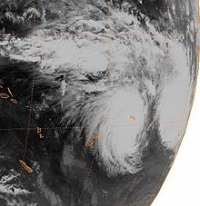
Satellite image of the storm on December 8 Formed December 4, 1991 Dissipated December 13, 1991 Highest winds 10-minute sustained:
165 km/h (105 mph)
1-minute sustained:
230 km/h (145 mph)Lowest pressure 940 mbar (hPa; 27.76 inHg) Fatalities 16 direct Damage $250 million (1991 USD) Areas affected Samoa, American Samoa, Cook Islands Part of the 1991–92 South Pacific cyclone season Severe Tropical Cyclone Val, also known as Cyclone Val, was a cyclone that struck Western Samoa and American Samoa on December 4, 1991. Lasting until December 13, the cyclone moved in a west-to-east trajectory. The cyclone lasted for five days in American Samoa and was designated by the United States Government as a major disaster on December 13, 1991. Western Samoa suffered more damage than American Samoa.[1][2][3][4] The cyclone devastated the islands with 150-mile-per-hour (240 km/h) winds and 50-foot (15 m) waves. The overall damages caused by Cyclone Val in American Samoa have been variously assessed. One estimate put the damages at $50 million in American Samoa and $200 million in Western Samoa due to damage to electrical, water, and telephone connections and destruction of various government buildings, schools, and houses.[5][6]
Contents
Meteorological history
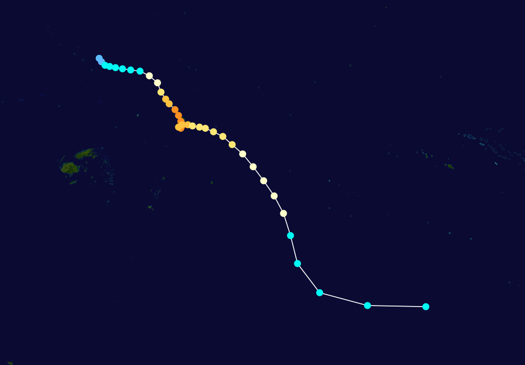
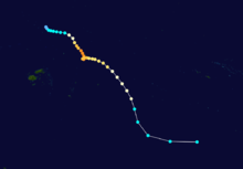 Storm path
From the time of its emergence as a tropical cyclone on December 4 southeast of Tuvalu until its dissipation on December 13 to the west of the southern Cook Islands in the Pacific Ocean, Cyclone Val's effects lasted for 10 days. As the depression moved towards the northeast, its intensity increased. It was categorized as a tropical cyclone and named tropical Cyclone Val on December 5, 1991. Soon after, Cyclone Val headed in the direction of Samoa. The cyclone's northeasterly winds were intensifying at this time. Cyclone Val made its first landing in Western Samoa at Savai'i on December 7 with a mean wind velocity of 45 meters per second (m/s). The gales extended 280 kilometres (170 mi) from the center; however, "Weakening upper-level winds caused Val to slow down for some time after crossing Savai'i and the system subsequently performed a small clockwise loop southwest of the island." This caused destruction in Samoa due to the high seas and the strong winds. Subsequently, after completing its loop track, it hit Tutuila and the port of Pago Pago on December 10 with a mean wind velocity of 35 m/s. Cyclone Val then moved towards the southeast, to the west of the southern Cook Islands, and gradually dissipated. Winds then dropped to less than cyclone force. The center of Cyclone Val's storms initially moved from the northwest on December 5 and 6 with strong northeasterly winds; it reached Savaii on December 7, and hit the west and east coasts of Samoa for three days. Considerable damage was done in western Savai'i.[5][7] Cyclone Val reached American Samoa on December 7, 1991, with 150-mile-per-hour (240 km/h) winds and 50-foot (15 m) waves. This continued until December 13; however, shortly after ceasing, the storm retreated in a loop and returned to the islands. The second pass of Cyclone Val was more devastating, with winds reaching 160 mph, and the most damage and loss of life.[3]
According to the annual reports of the National Oceanic and Atmospheric Administration (NOAA) American Samoa observatory, Cyclone Val struck Tutuila Island, the largest American Samoan island, from December 7–10. Cyclone Val's eye passed over the southern end of the island. Some of the facilities of the observatory were damaged.[8]
Impact
The cyclone destroyed over 65% of the residential homes on American Samoa and even more on the Samoan islands of Upolu and Savai'i.[3] Cyclone Val cut communications and power lines on the islands, and devastated fire stations, hospitals, government buildings, schools, and churches. Cyclone Val destroyed over 80% of agricultural crops.[3] One of the first areas hit was the Western Samoan island of Savai'i, which was described as looking like an atomic bomb had hit. A local remarked that "there was no green, no buildings standing, no shelter; just total and complete devastation."[3] Cyclone Val was reported to have killed 17 people and left 4,000 people homeless in American Samoa alone.[3] Cyclone Val was assessed to have had an impact 50% worse than Cyclone Ofa,[3] costing about $50 million in damage and putting a severe strain on agricultural production and the livelihoods of farmers on the islands.[6] In Fagatele Bay at Tutuila Island, where Cyclone Val made a direct pass, the coral reef was completely destroyed. A large strip of the coast was also eroded. In response to this disaster, the NOAA deputed an assessment team to survey the damage to the reefs.[9] In Tutuula, which accounts for 68% of American Samoa, the cable way, the longest single span cable way in the world, was permanently put out of service by Cyclone Val.[10] The cable had previously connected Pago Pago harbor with the TV tower erected on Mt. Alava (491m). The TV tower at Utulei, one of the three TV channels in Samoa, was completely ruined by Cyclone Val, resulting in it being cannibalized for parts to maintain the two remaining channels.[11] The Fagalele Boy's School, one of the oldest European-style buildings on the island in Leone, was destroyed by Cyclone Val.[12] According to a report of Greenpeace mission, the airport of Western Samoa was also devastated. The cyclone killed 15 people in Western Samoa, and one person in American Samoa. Preliminary estimates put the damages at US $200 million in Western Samoa and US $50 million in American Samoa.[5]
The damage caused by Cyclone Val was severe, as it occurred 18 months after Cyclone Olf (January 1990). Food production was halted; forests were damaged, and animals and birds were lost. The forest loss was as severe as 45% of Savai'i's timber logs. The damage that Cyclone Val caused over the entire region of Samoa was reported to be US$ 368 million.[13]
People were devoid of electricity and water supply for many days and depended on emergency aid. In Savai'i and Upolu, the percentage of destroyed houses was as high as 90%. In Western Samoa, the percentage was as high as 80%.[14]
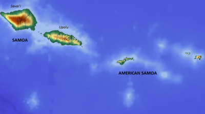 Map of Samoa and American Samoa
Val was reported as the worst cyclone to hit the Samoas in 100 years, as measured by the intensity of the wind and the severity of the damage it caused to the islands.[15] The President of United States declared the event as a "major disaster", for which federal assistance was provided.[7] The severity of Cyclone Val was aptly described by a local resident who stated: "But this Cyclone was stronger than me. For the first time I felt defeated I had never felt that before. I felt it was personal between me and Cyclone. I got depressed afterward."[16]
Aid was provided to the affected zones based on a categorization as Category A, B, C, D, E and F. The categories are defined by the degree of damage suffered. Assistance covered individuals, households, and the State and local governments. The assistance encouraged private, nonprofit organizations (NGOs) to meet and discuss expense-related emergency work and the repair or replacement of disaster-damaged infrastructure. Assistance provided "Hazard Mitigation Grants" to secure life and property from hazards.[2]
New Zealand and Australia provided considerable assistance to the affected population and helped with the reconstruction and recovery of infrastructure facilities. Samoans in the United states, Australia, and New Zealand helped finance the recovery by way of remittances to their relatives who suffered on the island.[13]
Law suit
In 1991, American Samoa purchased a $45 million "all risk" insurance policy from the firm Affiliated FM Insurance. The firm would only pay up to $6.1 million for the damages, arguing that the insurance did not cover water damage, only that caused by the wind.[6] Attorney William Shernoff investigated and discovered that the insurance company had altered American Samoa's insurance policy to exclude damages caused by "wind-driven water", despite the fact that it still covered cyclones.[6] The case was taken to court, and in 1995, the jury awarded the American Samoa Government $28.9 million. Soon after, the amount was doubled to $57.8 million to include punitive damages. The total damages awarded by the judgment was $86.7 million, which the judge stated to be "the largest insurance bad faith verdict in the state of California in 1995".[6]
The revenues of American Samoa for the fiscal years 2002 and 2003, which had been showing a downward trend, registered a substantial increase attributed to the insurance settlement of claims made to cover the damages caused by Cyclone Val. This resulted in fiscal surpluses. The deficit of US $23.1 million at the start of 2001 changed to a surplus of US $43.2 million by end of 2003.[17]
References
- ^ "American Samoa Cyclone Val". FEMA.gov. http://home.fema.gov/news/event.fema?id=2128. Retrieved December 16, 2010.
- ^ a b "American Samoa Cyclone Val Major Disaster Declared December 13, 1991". US Department of Homeland Security:FEMA. http://www.fema.gov/news/eventcounties.fema?id=2128. Retrieved December, 17, 2010.
- ^ a b c d e f g "Cyclone Wreaks Ruin in Samoa". The Church of Jesus Christ of the Latter-Day Saints. December 21, 1991. http://www.ldschurchnews.com/articles/21126/Cyclone-wreaks-ruin-in-Samoa.html. Retrieved December 16, 2010.
- ^ "Effect of Cyclone Val on areas proposed for inclusion in the National Park of American Samoa". A report to the U.S. National Park Service. Botany.hawaii.edu. p. 3. http://www.botany.hawaii.edu/basch/uhnpscesu/pdfs/sam/Pierson1992AS.pdf. Retrieved December 18, 2010.
- ^ a b c "The South Pacific and southeast Indian Ocean Tropical Cyclone Season 1991–92" (pdf). Australian Met Magazine 43.3. September 1994. pp. 184–185. http://www.bom.gov.au/amm/docs/1994/gill.pdf. Retrieved December 18, 2010.
- ^ a b c d e "Representing An Entire Country: American Samoa Government v. Affiliated FM Insurance". Shernoff. http://www.shernoff.com/landmark-cases/Representing-American-Samoa.html. Retrieved December 16, 2010.
- ^ a b "FEMA posts 11 disaster declarations for territory over last 40 yrs". Samoanews. Thursday November 4, 2010. http://www.samoanews.com/viewstory.php?storyid=20421&edition=1288864800. Retrieved December 18, 2010.
- ^ "Observatory History". 1991. Earth System Research Laboratory. http://www.esrl.noaa.gov/gmd/obop/smo/history.html. Retrieved December 17, 2010.
- ^ "Fagatele Bay Marine Sanctuary". Research and Monitoring. Official Site of the Fagatele Bay National Marine Sanctuary. http://fagatelebay.noaa.gov/html/research.html. Retrieved December 17, 2010.
- ^ Stanley, p. 475
- ^ Stanley, pp. 475–477
- ^ Stanley, p. 480
- ^ a b Ward, pp. 20–21
- ^ "Storm of the Century Devastates the Samoas for the Second Year Running". Greenpeace.org. http://archive.greenpeace.org/climate/database/records/zgpz0814.html. Retrieved December 17, 2010.
- ^ Ward, pp. 17–21
- ^ Gold, Jerome (1994). Cyclones. Black Heron Press. pp. 77, 80. ISBN 093077325X. http://books.google.co.in/books?id=N0PmYqgMsX0C&pg=PA76&dq=Cyclone+Val&hl=en&ei=4AoLTdLIEI7JrAeF-IDBCw&sa=X&oi=book_result&ct=result&resnum=4&ved=0CDcQ6AEwAw#v=onepage&q=Cyclone%20Val&f=false. Retrieved December 17, 2010.
- ^ U.S. Insular Areas: Economic, Fiscal, & Financial Accountability Challenges. DIANE Publishing. p. 23. ISBN 1422311538. http://books.google.com/books?id=yIzyUrFl_GkC&pg=PA23. Retrieved December 17, 2010.
Bibliography
- Stanley, David (2004). Moon Handbooks South Pacific. David Stanley. ISBN 1566914116. http://books.google.com/books?id=EDGapfBX-CAC&pg=PA475. Retrieved December 18, 2010.
- Ward, R. Gerard; Paul Ashcroft (1998). Samoa: mapping the diversity. editorips@usp.ac.fj. ISBN 9820201349. http://books.google.com/books?id=cso6JiinsaEC&pg=PA19. Retrieved December 17, 2010.
External links
- World Meteorological Organization
- Fiji Meteorological Service
- Meteorological Service of New Zealand
- Joint Typhoon Warning Center
1970s 1980s 1990s 2000s 2010s Categories:- Retired South Pacific cyclones
- 1991 in Samoa
- 1991 in American Samoa
- Natural disasters in Samoa
- Natural disasters in American Samoa
- Category 4 South Pacific cyclones
- 1991–92 South Pacific cyclone season

Wikimedia Foundation. 2010.