- Charlotte, Tennessee
-
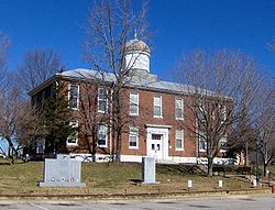
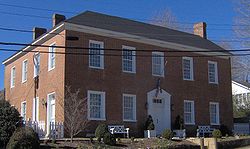
Charlotte, Tennessee — Town — Dickson County Courthouse in Charlotte Location of Charlotte, Tennessee Coordinates: 36°10′44″N 87°20′39″W / 36.17889°N 87.34417°W Country United States State Tennessee County Dickson Area – Total 1.7 sq mi (4.5 km2) – Land 1.7 sq mi (4.5 km2) – Water 0.0 sq mi (0.0 km2) Elevation 650 ft (198 m) Population (2000) – Total 1,153 – Density 661.0/sq mi (255.2/km2) Time zone Central (CST) (UTC-6) – Summer (DST) CDT (UTC-5) ZIP code 37036 Area code(s) 615 FIPS code 47-13080[1] GNIS feature ID 1305868[2] Charlotte is a town in Dickson County, Tennessee, United States. The population was 1,153 at the 2000 census. It is the county seat of Dickson County[3].
Contents
Geography
Charlotte is located at 36°10′44″N 87°20′39″W / 36.17889°N 87.34417°W (36.178784, -87.344304)[4]. The town is situated amidst the hills that comprise part of the western section of the Highland Rim, nearly halfway between Dickson and Ashland City. A small stream known as Town Branch, which is part of the Cumberland River watershed, flows through Charlotte from west-to-east.
Charlotte is centered around the junction of Tennessee State Route 49, which connects Charlotte with Ashland City and Kentucky to the northeast and upper West Tennessee to the northwest, and State Route 48, which connects the town to Dickson and U.S. Route 70 to the southwest and Clarksville to the north.
According to the United States Census Bureau, the town has a total area of 1.7 square miles (4.4 km2), all of it land.
Demographics
As of the census[1] of 2000, there were 1,153 people, 395 households, and 272 families residing in the town. The population density was 661.0 people per square mile (255.8/km²). There were 413 housing units at an average density of 236.8 per square mile (91.6/km²). The racial makeup of the town was 86.82% White, 10.67% African American, 0.35% Native American, 0.17% Asian, 0.09% Pacific Islander, 0.26% from other races, and 1.65% from two or more races. Hispanic or Latino of any race were 1.21% of the population.
There were 395 households out of which 30.1% had children under the age of 18 living with them, 52.2% were married couples living together, 11.9% had a female householder with no husband present, and 31.1% were non-families. 26.8% of all households were made up of individuals and 12.4% had someone living alone who was 65 years of age or older. The average household size was 2.50 and the average family size was 3.03.
In the town the population was spread out with 21.9% under the age of 18, 10.0% from 18 to 24, 35.5% from 25 to 44, 20.3% from 45 to 64, and 12.3% who were 65 years of age or older. The median age was 34 years. For every 100 females there were 111.9 males. For every 100 females age 18 and over, there were 120.0 males.
The median income for a household in the town was $32,279, and the median income for a family was $40,795. Males had a median income of $30,172 versus $21,442 for females. The per capita income for the town was $15,061. About 7.0% of families and 10.6% of the population were below the poverty line, including 18.4% of those under age 18 and 14.4% of those age 65 or over.
History
Charlotte was established in 1808 as the county seat for Dickson County, which had been created in 1803. The town was named for Charlotte Reeves Robertson, the wife of General James Robertson, who played prominent roles in the settlement of Middle Tennessee. Charlotte was officially incorporated in 1837.[5]
On May 30, 1830, a tornado destroyed most of downtown Charlotte. The roof of the courthouse was found 13 miles (21 km) away, and most of the county's early records were permanently lost. A new courthouse was completed in 1833, and still stands as the oldest functioning courthouse in the state of Tennessee.[6] While Charlotte thrived as a stage coach hub for much of the 19th-century, the arrival of the railroad in the latter half of the century shifted the area's industrial focus to Dickson, several miles to the southwest.[7]
Notable natives
- Oscar Robertson - Former basketball player born here.
References
- ^ a b "American FactFinder". United States Census Bureau. http://factfinder.census.gov. Retrieved 2008-01-31.
- ^ "US Board on Geographic Names". United States Geological Survey. 2007-10-25. http://geonames.usgs.gov. Retrieved 2008-01-31.
- ^ "Find a County". National Association of Counties. http://www.naco.org/Counties/Pages/FindACounty.aspx. Retrieved 2011-06-07.
- ^ "US Gazetteer files: 2010, 2000, and 1990". United States Census Bureau. 2011-02-12. http://www.census.gov/geo/www/gazetteer/gazette.html. Retrieved 2011-04-23.
- ^ Rick Hollis, "A Brief History of Dickson County, Tennessee," 4-5. Retrieved: 11 February 2008.
- ^ Hollis, "A Brief History of Dickson County, Tennessee," 5.
- ^ Hollis, "A Brief History of Dickson County, Tennessee," 11.
External links
Coordinates: 36°10′44″N 87°20′39″W / 36.178784°N 87.344304°W
Municipalities and communities of Dickson County, Tennessee Cities and towns Dickson | Burns | Charlotte | Slayden | Vanleer | White Bluff
Unincorporated
communitiesCategories:- Populated places in Dickson County, Tennessee
- Towns in Tennessee
- County seats in Tennessee
Wikimedia Foundation. 2010.


