- Mount Samson, Queensland
-
Mount Samson
Queensland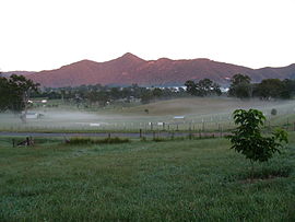
Population: 721 (2006 census) [1] Postcode: 4520 Location: 34 km (21 mi) from Brisbane LGA: Moreton Bay Region State District: Ferny Grove Federal Division: Dickson Suburbs around Mount Samson: Kobble Creek Samsonvale Cashmere Mount Glorious Mount Samson Clear Mountain Cedar Creek Cedar Creek Closeburn Mount Samson is about half way between Samford and Dayboro located in South East Queensland, Australia. It is roughly 34 km north west of Brisbane. It is located in the local government area of Moreton Bay Region. The suburb gets its name from the reasonably dominant Mount Samson which is part of the D'Aguilar Range.
Contents
Location
Mount Samson is a blend of acreage properties and small farms. The area was most recently dominated by agriculture such as dairy farming. Access to Mount Samson from Brisbane is along Samford Road and Mount Samson Road.
Climate
Mount Samson has a sub-tropical climate with very hot humid summers and mild, dry, sunny winters. Most rain falls during the height of summer, between November and February. Whilst summer maximum average temperatures generally linger around 30C, the summer months have some extremely hot days, sometimes as high as 40C.
Facilities
Samsonvale Hall is located on Winn Road on the opposite side from the primary school.
Education
Mount Samson has one local primary school called Mount Samson State School.
References
- ^ Australian Bureau of Statistics (25 October 2007). "Mount Samson (Pine Rivers Shire) (State Suburb)". 2006 Census QuickStats. http://www.censusdata.abs.gov.au/ABSNavigation/prenav/LocationSearch?collection=Census&period=2006&areacode=SSC36905&producttype=QuickStats&breadcrumb=PL&action=401. Retrieved 2008-02-24.
External links
- University of Queensland: Queensland Places: Mount Samson
- Satellite view of Mount Samson on Google Maps
Categories:- Suburbs of Moreton Bay Region

Wikimedia Foundation. 2010.