- Duryea, Pennsylvania
-
Duryea, Pennsylvania — Borough — Aerial View of Duryea, looking southwest.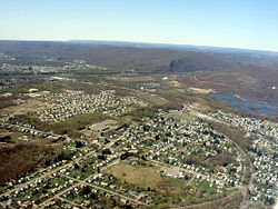

 Duryea, Pennsylvania
Coordinates: 41°20′52″N 75°45′30″W / 41.34778°N 75.75833°WCoordinates: 41°20′52″N 75°45′30″W / 41.34778°N 75.75833°W Country United States State Pennsylvania County Luzerne Settled Incorporated 1891 Government – Type Borough Council – Mayor Keith Moss Area – Total 5.89 sq mi (15.3 km2) – Land 3.80 sq mi (9.8 km2) – Water 2.09 sq mi (5.4 km2) Elevation 623 ft (190 m) Population (2000) – Total 4,634 – Density 841.0/sq mi (324.7/km2) Time zone Eastern (EST) (UTC-5) – Summer (DST) EDT (UTC-4) Zip code 18642 Area code(s) 570 Website Duryea's website Duryea is a borough in the Greater Pittston area of Luzerne County, Pennsylvania, USA, nine miles (14 km) south of Scranton on the Lackawanna River. Duryea was incorporated as a borough in 1891. Coal mining and the manufacture of silk were the chief industries in the early years of its existence. The population numbered 7,487 in 1910, and 8,275 in 1940. The population was 4,634 at the 2000 census. In 2011, the borough received national notoriety for its role in the landmark Supreme Court case Borough of Duryea v. Guarnieri in which the court stated that "a government employer's allegedly retaliatory actions against an employee do not give rise to liability under the Petition Clause unless the employee's petition relates to a matter of public concern."
Contents
Geography
Duryea is located at 41°20′52″N 75°45′30″W / 41.34778°N 75.75833°W (41.347729, -75.758302)[1].
According to the United States Census Bureau, the borough has a total area of 5.7 square miles (15 km2), of which 5.5 square miles (14 km2) is land and 0.2 square miles (0.52 km2) (3.84%) is water.
Mining and industry affecting environment and population (first half of 20th century)
Like many of the surrounding towns (Pittston, Hugestown, Old Forge), Duryea was abandoned when the need for deep-mined coal diminished. Three large colliers once operated there, processing the coal for transport. Like the other nearby towns the coal was often mined directly under the town itself. Remnants of strip mines and 'culm' banks that were never properly cleaned up and redeveloped litter the landscape.
On the other side of the Lackawana River, sand and gravel quarry operations continue to spoil what was once a beautiful landscape and riverway. The Lackawana River is heavily polluted with the outflow from abandoned mine tunnels and is choked with orange sediment.
Population has been declining for years, with increased gentrification.
Loss of independence from surrounding towns (Pittston) (last half of 20th century)
Duryea was once fiercely independent. Primarily populated by Polish immigrants and their descendants, the town benefited from the coal industry and silk mills and was a self-contained community with its own Main Street and School District.
After the death of coal and the loss of the silk mill, the town encouraged the likes of Schott Optical and Topps Bubble Gum to establish medium-sized plants in the town. However, these would never replace the jobs and revenue provided by coal. Declining population added to the problem and resulted in the takeover of the town's schools by the Pittston Area School District. These were eventually phased out and shut down with Duryea Elementary being shut down in 1981. Parents now had no choice but to bus their children to the new elementary and middle schools in Pittston 10–15 minutes away.
Industry in the 21st century
Investment spurred by Marcellus Shale natural gas exploration in the areas surrounding Duryea has transformed an antiquated, weed-ridden rail yard in Duryea, known as the Pittston Yard, into a transloading terminal teeming with rail and trucking activity. The yard transloads sand from rail cars to trucks for use in Marcellus Shale gas drilling operations.
The Reading & Northern Railroad Co. invested in Pittston Yard in late 2009 and early 2010, laying track to accommodate 100 new rail cars and constructing a facility to store and hold up to 800 cars of sand to be used in hydraulic fracturing, or “fracking,” operations at Marcellus Shale drill sites throughout Northeastern Pennsylvania. [1]
Demographics
At the 2000 census[2], there were 4,634 people, 1,984 households, and 1,297 families residing in the borough. The population density was 841.0 per square mile (324.7/km²). There were 2,151 housing units at an average density of 390.4 per square mile (150.7/km²). The racial makeup of the borough was 98.86% White, 0.26% African American, 0.11% Native American, 0.35% Asian, 0.09% from other races, and 0.35% from two or more races. Hispanic or Latino of any race were 0.30% of the population.
There were 1,984 households, of which 24.0% had children under the age of 18 living with them, 49.0% were married couples living together, 12.1% had a female householder with no husband present, and 34.6% were non-families. 32.0% of all households were made up of individuals and 17.6% had someone living alone who was 65 years of age or older. The average household size was 2.32 and the average family size was 2.94.
Age distribution was 19.1% under the age of 18, 6.5% from 18 to 24, 27.2% from 25 to 44, 26.5% from 45 to 64, and 20.6% who were 65 years of age or older. The median age was 43 years. For every 100 females there were 88.2 males. For every 100 females age 18 and over, there were 86.4 males.
The median household income was $32,207, and the median family income was $41,775. Males had a median income of $32,715 versus $25,786 for females. The per capita income for the borough was $17,598. About 6.3% of families and 8.1% of the population were below the poverty line, including 2.6% of those under age 18 and 15.9% of those age 65 or over.
References
- ^ "US Gazetteer files: 2010, 2000, and 1990". United States Census Bureau. 2011-02-12. http://www.census.gov/geo/www/gazetteer/gazette.html. Retrieved 2011-04-23.
- ^ "American FactFinder". United States Census Bureau. http://factfinder.census.gov. Retrieved 2008-01-31.
External links
Categories:- Populated places established in 1891
- Boroughs in Luzerne County, Pennsylvania


Wikimedia Foundation. 2010.