- Kinzie Street railroad bridge
-
Kinzie Street railroad bridge 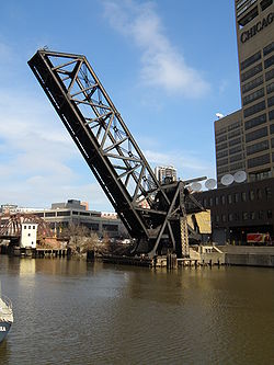
Kinzie Street railroad bridge permanently locked in the raised positionOfficial name Chicago & North Western Railway, Kinzie Street drawbridge Other name(s) Carroll Avenue bridge Crosses Chicago River Locale Chicago Design bascule bridge Total length 195.83 feet (59.69 m)[1] Width 41.7 feet (12.7 m)[1] Longest span 170 feet (52 m)[1] Construction begin December 1907 Opened September 19, 1908[1] Heritage status Chicago Landmark Area Map 
Coordinates 41°53′18.7″N 87°38′21″W / 41.888528°N 87.63917°WCoordinates: 41°53′18.7″N 87°38′21″W / 41.888528°N 87.63917°W The Chicago and North Western Railway's Kinzie Street railroad bridge (also known as the Carroll Avenue bridge) is a single leaf bascule bridge across the north branch of the Chicago River in downtown Chicago, Illinois. At the time of its opening in 1908 it was the world's longest and heaviest bascule bridge. Previous bridges on the same site included the first bridge to cross the Chicago River, Chicago's first railroad bridge, and one of first all-steel bridges in the United States.
The Chicago Sun-Times, the last railroad customer to the east of the bridge, moved their printing plant out of downtown Chicago in 2000, and the bridge has been unused since. It was designated a Chicago Landmark in 2007.
Contents
Location
 Night view looking north from Lake Street bridge showing Wolf Point and Kinzie Steet railroad bridge. Among the buildings and structures shown are (left to right) Left Bank at K Station (300 North Canal), 333 North Canal, Kinzie Street railroad bridge, 350 West Mart Center, Merchandise Mart, 300 North LaSalle, Franklin Street Bridge and part of 333 Wacker Drive.
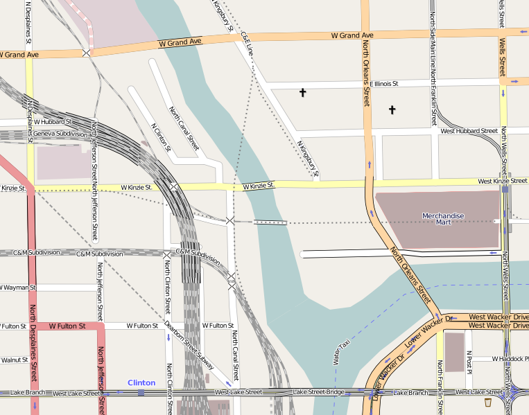
Kinzie Street railroad bridge is located at 41°53′18.7″N 87°38′21″W / 41.888528°N 87.63917°W, it runs in an east-west orientation, spanning the north branch Chicago River between the Near North Side and Near West Side community areas of Chicago. To the south is the historic area of Wolf Point at the confluence of the main stem of the Chicago River with the north and south branches, and to the east is 350 West Mart Center and Merchandise Mart. The railroad track across the bridge is a spur line of the Union Pacific Railroad,[1] that branches off from the route of the Union Pacific/North Line about 1 mile (1.6 km) north-west of the bridge.[2] The railroad to the east of the bridge has been abandoned since 2000.[3]
Previous bridges
Through the 1820s a small settlement grew around Wolf Point, at the forks of the Chicago River. In June 1829, Samuel Miller—who owned a tavern on the north shore of the river beside the forks—and Archibald Clybourne were authorized to run a ferry across the mouth of the north branch of the river, just south of the present Kinzie Street.[4] By 1832 the ferry had been replaced with a pedestrian bridge that was the first bridge to be constructed across the Chicago River.[5]
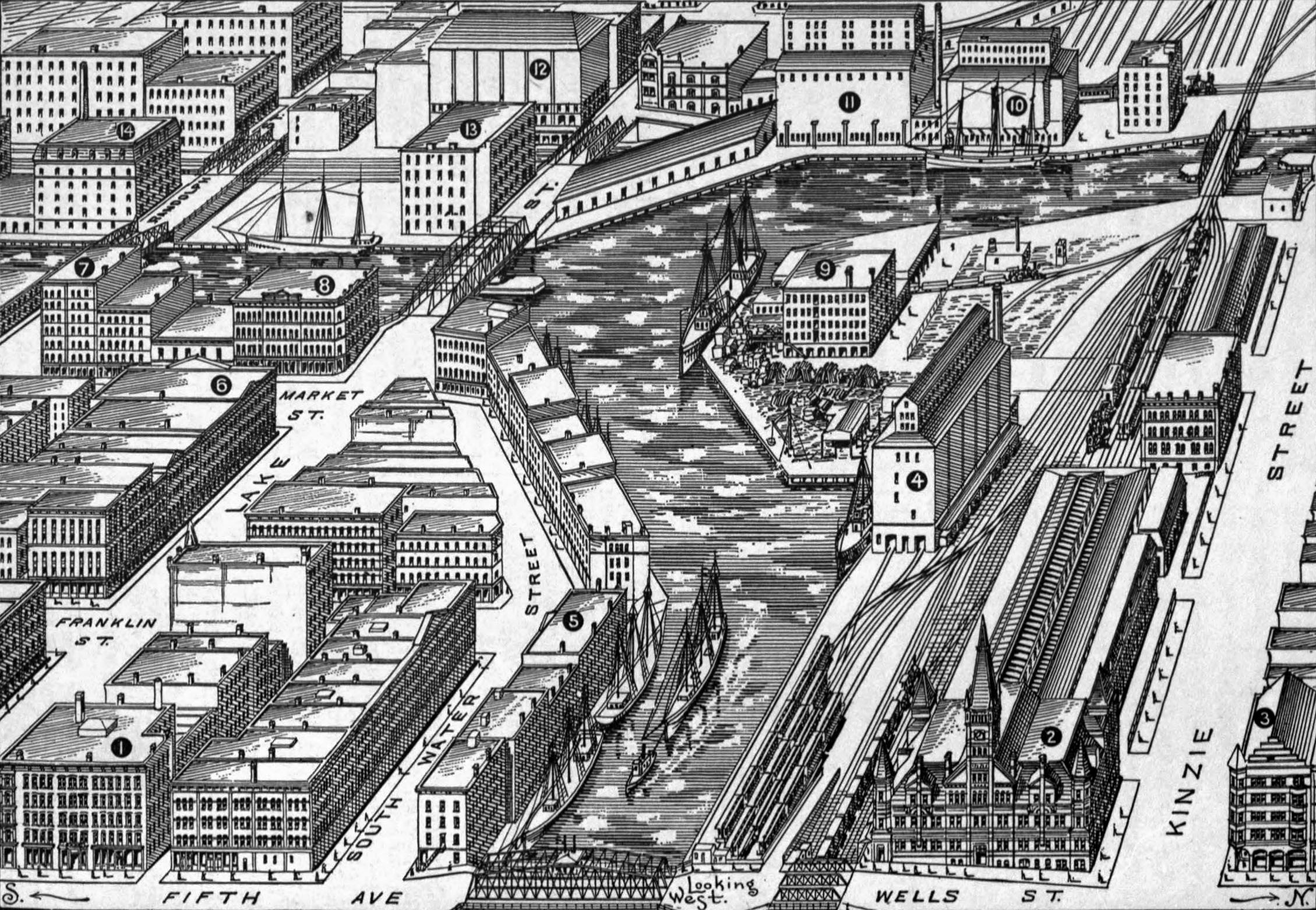
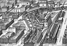 Bird's-eye view of Wolf Point viewed from the west as it appeared in 1893. The 1879–1898 swing bridge is visible in the top right of the drawing.
On October 10, 1848 the Galena and Chicago Union Railroad—Chicago's first railroad—began operating out of a depot on the west side of the Chicago River, near the corner of Canal and Kinzie Streets. Though the City of Chicago had authorized the railroad to construct a bridge across the north branch of the river as early as July 17, 1848,[6] it was not until 1851 that the railroad began to purchase the land needed to build the Wells Street Station to the east of the river.[7] In order to access the new station a floating pontoon bridge designed by Jenks D. Perkins was built across the north branch at roughly the same location as the earlier pedestrian bridge. This bridge—the first railroad bridge in Chicago—was completed in 1852,[1][8] allowing trains to access the railroad's new Wells Street Station and subsequently industry on the north bank of the Chicago River as far as the Ogden Slip and Navy Pier.[2][9]
The original railroad bridge was replaced by a swing bridge in 1879 that, along with the Glasgow Railroad Bridge across the Missouri River, was one of the United States' first all steel railroad bridges.[10] This bridge was constructed from Bessemer steel, which proved too brittle and so the bridge was replaced again in 1898.[1] The replacement bridge was constructed on land and floated into position, allowing the old structure to be removed and the new one put in place in 27½ hours on March 13 and March 14, 1898.[11][12]
Bascule bridge
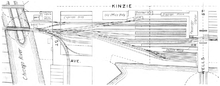 This 1901 plan of the track layout at Wells Street Station shows the close proximity of the Kinzie Street road bridge to the railroad bridge, and the obstruction that they created in the river
River traffic and railroad traffic were increasingly in competition with each other. In October 1879 a disaster was narrowly avoided when a seven-coach passenger train with 800 people onboard approached the open swing bridge too fast and was barely able to stop in time, ending up with its front wheels hanging off the approach road over the river.[13] Meanwhile boats on the river were getting larger and finding it increasingly difficult to navigate the bridges at the mouth of the north branch, so the Army Corps of Engineers ordered the clearing of three swing bridges near Kinzie Street that were obstructing river traffic.[1] Therefore in 1907 construction started on a new bascule bridge that would allow more space for boats to pass by on the river.
Design and construction
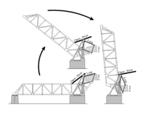 Schematic of Kinzie Street railroad bridge
The bridge is designed to carry two railroad tracks across the river. Its superstructure consists of two spans constructed by the Strauss Bascule & Concrete Bridge Company: a 26-foot (7.9 m) plate-girder span on the west bank of the river and the 170-foot (52 m) movable main span that rests on the east trunnion pier.[1] The size and weight of the main span, which, when completed would be world's longest and heaviest bascule span,[1] required the trunnion pier to be constructed on foundations that extend to the bedrock 94 feet (29 m) below the river bed. To achieve this caissons were sunk to a depth of 29 feet (8.8 m) below the river bed and then 10-foot (3.0 m) diameter wells were sunk the remaining 65 feet (20 m).[14] The substructure of the bridge was constructed by the Great Lakes Dredge and Dock Company.
Usage
The Chicago and North Western Railway originally planned for two bridges side-by-side that could carry four railroad tracks into the Wells Street Station.[7] However, by the time that the first bridge opened on September 19, 1908 an alternative scheme was already underway that led to the closure of Wells Street Station and its replacement it with a new terminal on the west bank of the river. When the new station (now the Ogilvie Transportation Center) opened in 1911, Kinzie Street railroad bridge was left to handle freight traffic only. In 1930 Merchandise Mart was opened on the site of the old Wells Street Station. Merchandise Mart was built on air rights of the Chicago and North Western, and in the spring of 1932 the railroad opened a new freight house underneath the building that was designed to handle 1,000 short tons (910,000 kg) of outbound and 600 short tons (540,000 kg) of inbound freight per day.[15][16]
Abandonment
During the second half of the 20th century the number of companies using the railroad for shipping on Chicago's near north side declined severely.[17] In the 1970s customers at the east end of the line included the Curtiss candy factory and the Jardine Water Purification Plant.[2] The construction of the Columbus Drive Bridge in 1982 wiped out part of the right of way and the spur to Navy Pier was abandoned.[2] Service to the Tribune Tower also ended in the 1980s,[2] and by the 1990s traffic along the remaining section of the spur served only one customer, the Chicago Sun-Times, with only one train per day.[18] The newspaper moved their printing plant out of downtown Chicago in early 2001 leaving no traffic across the bridge and it has since been permanently raised in the open position.[19][2] On December 12, 2007 the bridge was one of 12 historic Chicago railroad bridges to be designated as Chicago Landmarks.[20]
Proposals for reuse
Tests were conducted in 1953 to see if the spur could be used as a part of a commuter line with stops at Merchandise Mart, State Street, and Michigan Avenue, but the plan was dropped in 1954 for financial reasons.[2] In the 1970s architect Harry Weese suggested a light rail line along the spur to connect Chicago's downtown stations with the River North neighborhoods.[2] In 2008 the CIty of Chicago Department of Transportation commissioned an alternatives analysis to look at a proposal to create a transit link from Union Station and the Ogilvie Transportation Center to Michigan Avenue using the Union Pacific train tunnel running under the Apparel Center, the Merchandise Mart and other buildings east toward North Michigan Avenue. The proposed Carroll Avenue Transitway would include the retrofitting of Kinzie Street railroad bridge to carry buses or trams.[21]
Notes
- ^ a b c d e f g h i j Spivey, Justin M. "Chicago & Northwestern Railway, Kinzie Street Bridge". Historic American Engineering Record. The Library of Congress. http://memory.loc.gov/cgi-bin/query/r?ammem/hh:@field(DOCID+@lit(IL0821)). Retrieved February 19, 2008.
- ^ a b c d e f g h Goldsborough, Bob (June 23, 2002). "A bend in the tracks - Rail spur from Streeterville's industrial past seen as surface, light-rail link in city's future". Chicago Tribune.
- ^ Mann, Thomas (2004). "Navy Pier Line Study". Chicago Switching. http://www.chicagoswitching.com/v6/articles/article.asp?articleid=73. Retrieved July 19, 2010.
- ^ Andreas, Alfred Theodore (1884). History of Chicago. 1. New York: Arno Press. p. 104. ISBN 040506845X. http://books.google.com/?id=wP0TAAAAYAAJ. Retrieved July 19, 2010.
- ^ Albert F. Scharf (1908). Chicago, 1835 (Map).
- ^ Tuley, Murray F. (1873). Laws and Ordinances Governing the City of Chicago. Chicago: Bulletin printing company. pp. 268–269.
- ^ a b Yesterday and today: a history of the Chicago and North Western railway system. Chicago and North Western Railway Company. 1910. pp. 34–35. http://books.google.com/?id=UY0pAAAAYAAJ. Retrieved July 19, 2010.
- ^ Historic American Engineering Record historian Justin M Spivey notes that the 1852 pontoon bridge may have been short-lived, as a bird's-eye view of Chicago published in 1857 shows what appears to be a swing bridge crossing the river at this location. See: Spivey, Justin M. "Chicago & Northwestern Railway, Kinzie Street Bridge". Historic American Engineering Record. http://memory.loc.gov/cgi-bin/query/r?ammem/hh:@field(DOCID+@lit(IL0821)). Retrieved February 22, 2010. and Inger, Christian; Palmatary, James T. "Bird's Eye View of Chicago, 1857". The Electronic Encyclopedia of Chicago. Chicago Historical Society. http://www.encyclopedia.chicagohistory.org/pages/10603.html. Retrieved July 22, 2010.
- ^ "CNW's Navy Pier Line". Chicago Switching. http://www.chicagoswitching.com/v6/articles/articlelisting.asp?locationid=6. Retrieved October 8, 2010.
- ^ Misa, Thomas J. (1995). A Nation of Steel: The Making of Modern America, 1865-1925. JHU Press. p. 75. ISBN 0801860520.
- ^ Finley, William H (February 1899). "Rebuilding of the Kinzie Street Drawbridge of the Chicago & Northwestern Ry.". Journal of the Western Society of Engineers 4 (1): 51–72. http://books.google.com/?id=opcPAQAAIAAJ&pg=PA51. Retrieved July 21, 2010.
- ^ "Change in Railway Bridge; Little Delay to Traffic". Chicago Daily Tribune. August 21, 1907.
- ^ "Narrow Escape. A Train Stops on the Brink of the River". Chicago Daily Tribune. October 10, 1879.
- ^ Colby, Frank Moore, ed (1911). New International Yearbook: A Compendium of the World's Progress for the year 1910. New York: Dodd, Mead and Company. p. 263.
- ^ "Opens Notable Freight House on Air Rights Property". Railway Age: 471–473. 1935.
- ^ Grant, H. Roger (1996). The North Western: A History of the Chicago & North Western Railway System. DeKalb: Northern Illinois University Press. p. 154. ISBN 0-87580-214-1.
- ^ Mann, Thomas. "The Decline of Railroad Customers Chart". Chicago Switching. MannResearch. http://www.chicagoswitching.com/v6/articles/article.asp?articleid=66. Retrieved 21 July 2010.
- ^ Mika, J (1999). "Afternoon Train on Carroll Avenue". http://www.mannresearch.com/lakewood/carroll2.html. Retrieved July 19, 2010.
- ^ Larson, Lisa (November 1, 2001). "Chicago Sun-Times in full production at new $120m plant". Newspapers & Technology. http://www.newsandtech.com/issues/2001/11-01/nt/11-01_suntimes.htm. Retrieved February 19, 2008.[dead link]
- ^ (PDF) CHICAGO LANDMARKS: Individual Landmarks and Landmark Districts designated as of January 1, 2008. Commission on Chicago Landmarks. January 1, 2008. http://www.tonythetiger.frih.net/CCL_Booklet_1-1-08.pdf.
- ^ "About that old train bridge… City would use it to link trains with Michigan Ave". Chicago Sun Times. November 3, 2008.
Chicago Landmark transportation National Historic Landmark,
National Register of Historic Places,
Chicago LandmarknoneNational Historic Landmark,
National Register of Historic PlacesnoneNational Register of Historic Places,
Chicago LandmarkChicago Landmark Chicago, Milwaukee & St. Paul Railway Bridge No. Z-2 · Chicago & Northwestern Railway Bridge · Cortland Street Drawbridge · Garfield Boulevard "L" Station and Overpass · LaSalle Street Cable Car Powerhouse · Michigan Avenue Bridge and Esplanade · Pennsylvania Railroad Bridge · Union StationApartments · Culture · Education · Historic Districts · Houses · Memorials and Monuments · Municipal · Skyscrapers · Transportation · WorshipCategories:- Bridges completed in 1907
- Bascule bridges
- Landmarks in Chicago, Illinois
- Bridges in Chicago, Illinois
- Railroad bridges in Illinois
- Former railway bridges in the United States


Wikimedia Foundation. 2010.