- Cherry Avenue Bridge
-
Cherry Avenue Bridge 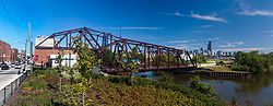
Cherry Avenue bridge from North Avenue road bridgeCrosses North Branch Canal of the Chicago River Locale Chicago Designer Chicago, Milwaukee and St. Paul Railway Design bob-tail swing bridge Total length 230 feet (70 m)[1] Longest span 134.5 feet (41.0 m)[1] Construction begin 1901 Construction end 1902[1] Heritage status Chicago Landmark Coordinates 41°54′37.1″N 87°39′19.9″W / 41.910306°N 87.655528°WCoordinates: 41°54′37.1″N 87°39′19.9″W / 41.910306°N 87.655528°W The Cherry Avenue Bridge (North Avenue railroad bridge, or Chicago, Milwaukee & St. Paul Railway, Bridge No. Z-2) is an asymmetric bob-tail swing bridge in Chicago, Illinois that carries the Chicago Terminal Railroad, pedestrians, and cyclists across the North Branch Canal of the Chicago River. It was constructed in 1901–02 by the Chicago, Milwaukee and St. Paul Railway, and it is a rare example of this type of bridge; it was designated a Chicago Landmark on December 12, 2007.[2]
Contents
Location
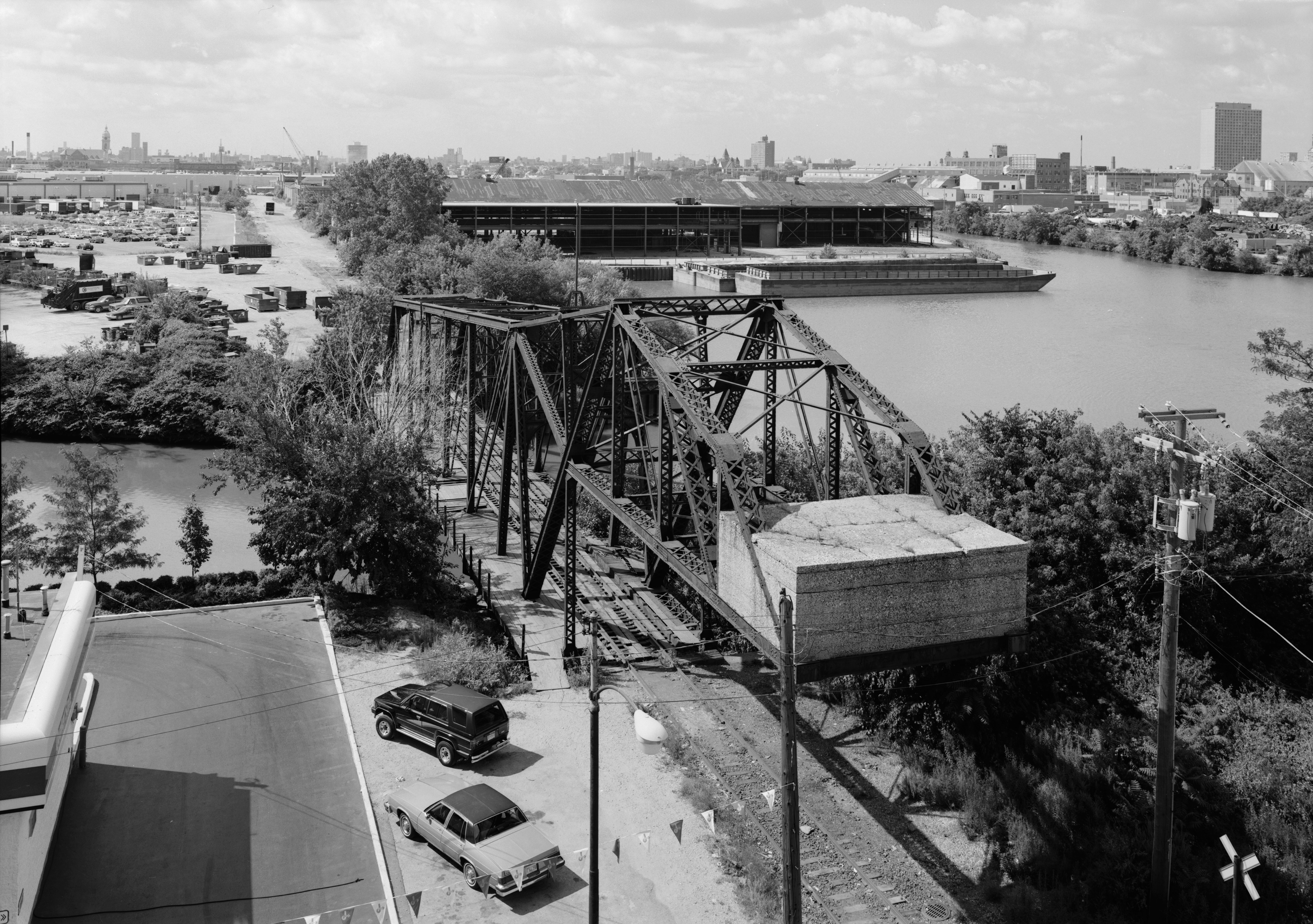
Cherry Avenue bridge is located at 41°54′37.1″N 87°39′19.9″W / 41.910306°N 87.655528°W; it runs in an north-south orientation, spanning the North Branch Canal of the Chicago River to provide railroad access to Goose Island, an industrial area in the Near North Side community area of Chicago. The railroad track across the bridge is a spur line of the Chicago Terminal Railroad, that branches off from the route of the Union Pacific mainline about 0.5 miles (0.80 km) north-west of the bridge. The railroad continues for about 0.5 miles (0.80 km) south on Goose Island. North Avenue (Illinois Route 64) runs east-west at the north end of the bridge, crossing the North Avenue Bridge over the north branch of the Chicago River about 300 feet (91 m) to the west.
History
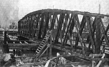 Previous bridge prior to demolition
Goose Island is a man-made island on the north branch of the Chicago River that was formed in the 1850s by the digging of the North Branch Canal.[3] In 1871 the Chicago and Pacific Railroad started construction of a railroad from Goose Island through Elgin, Illinois to Byron, Illinois.[4] This company was absorbed into the Chicago, Milwaukee and St. Paul Railway in 1880.[5] The Cherry Avenue bridge was constructed in 1901–02[1] by the Chicago, Milwaukee and St. Paul to replace a 20 year-old bridge on the same location.[6] It spans the North Branch Canal of the Chicago River providing the only railroad access to Goose Island.[7]
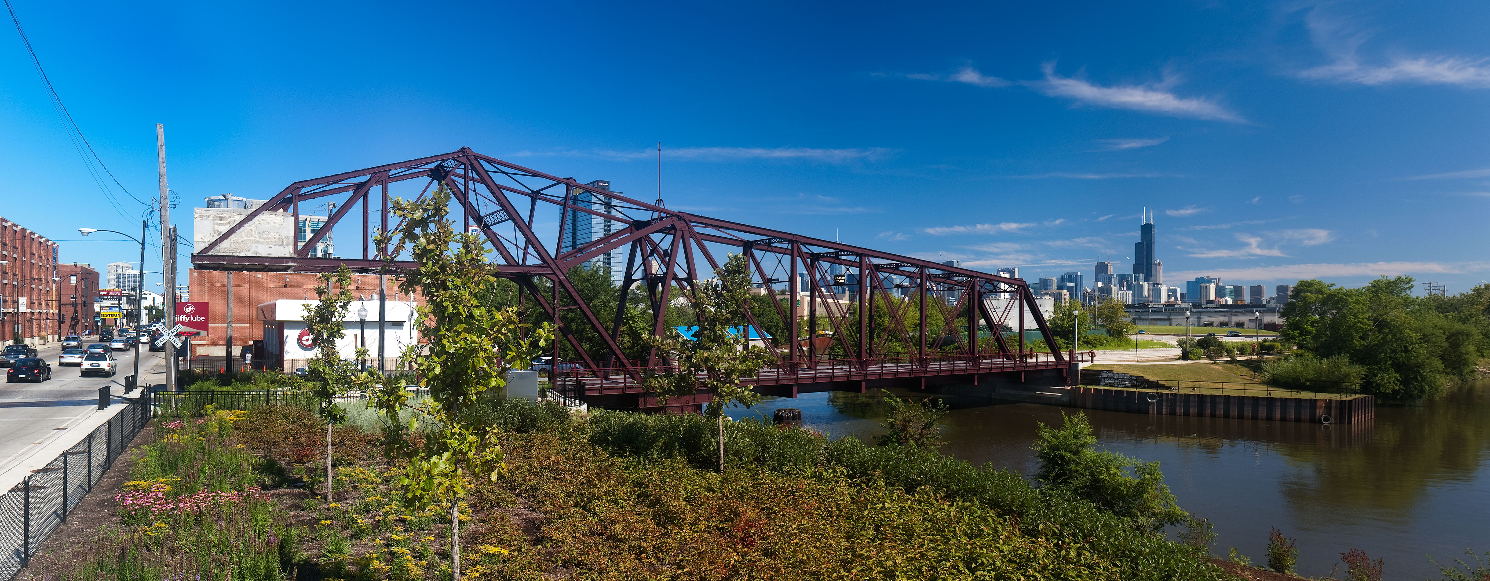
 Cherry Avenue bridge as it appeared in 1999 before restoration
Railroad operation on Goose Island was taken over by the Soo Line Railroad in 1986, and then by the Chicago Terminal Railroad in January 2007. The bridge was purchased by the City of Chicago in 2008,[8] and restored in 2008–09 adding new decking and lights to enable safe pedestrian access.[9]
Structure
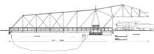 Eastern elevation of the bridge
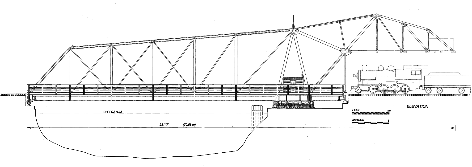
The bridge is one of two bob-tail swing bridges constructed by the Chicago, Milwaukee & St. Paul Railway on the North Branch of the Chicago River.[10] The bridge runs north-south, the pivot pier is on the shore on the north side of the channel with a 134.5-foot (41.0 m) long, 40-foot (12 m) heigh Pratt truss arm that spans the channel, and a 70-foot (21 m) arm that carries the 280,000-pound (130,000 kg) counter-weight 20 feet (6.1 m) above the tracks.[1][6] The bridge is no longer operable, but when constructed it was able to swing to the east, to an angle of 82.5˚ when parallel to the dock wall.[1] The bridge was designed to carry a single railroad track, but also may originally have been intended for use by other vehicular traffic on Cherry Avenue.[1] A sidewalk is cantilevered from the east side of the bridge.
References and notes
- ^ a b c d e f g "Chicago, Milwaukee & St. Paul Railway, Bridge No. Z-2, Spanning North Branch Canal at North Cherry Avenue, Chicago, Cook County, IL". Historic American Engineering Record. http://hdl.loc.gov/loc.pnp/hhh.il0822. Retrieved 2009-05-03.
- ^ (PDF) CHICAGO LANDMARKS: Individual Landmarks and Landmark Districts designated as of January 1, 2008. Commission on Chicago Landmarks. 2008-01-01. http://www.tonythetiger.frih.net/CCL_Booklet_1-1-08.pdf.
- ^ Duis, Perry (1998). Challenging Chicago: Coping With Everyday Life, 1837–1920. Urbana: University of Illinois Press. p. 95. ISBN 0252023943.
- ^ Cary, John W (1892). The Organization and History of The Chicago, Milwaukee & St. Paul Railway Company. Press of Cramer, Aikens, & Cramer. pp. 253. http://books.google.com/?id=44N_byxGgwsC&pg=253#v=onepage&q. Retrieved 2010-07-25.
- ^ Duis, Perry (1998). Challenging Chicago. University of Illinois Press. p. 97. ISBN 0252023943.
- ^ a b "A Counterbalance Swing Bridge on the Chicago Milwaukee & St. Paul". The Railway Age 33 (10): 290–291. March 2, 1902. http://books.google.com/?id=wYhMAAAAYAAJ&pg=290. Retrieved 2010-07-25.
- ^ Holth, Nathan. "North Avenue Railroad Bridge". Historic Bridges of Michigan and Elsewhere. http://www.historicbridges.org/illinois/northrr/index.htm. Retrieved 2009-05-03.
- ^ Quinlan, Anne (2008-08-04). "STB Finance Docket No. 35154". Surface Transportation Board. http://www.stb.dot.gov/decisions/ReadingRoom.nsf/UNID/0FF4FA7DF28A878D8525749C0068C75F/$file/39153.pdf. Retrieved 2009-05-03.
- ^ "Cherry Avenue Bridge". Rausch Construction Company. http://www.rauschconstruction.com/cherry-avenue-bridge. Retrieved 2009-05-03.
- ^ The other is bridge No. Z-6, downstream of the Cortland Street Drawbridge, see "Chicago, Milwaukee & St. Paul Railway, Bridge No. Z-6, Spanning North Branch of Chicago River, South of C, Chicago, Cook County, IL". Historic American Engineering Record. http://hdl.loc.gov/loc.pnp/hhh.il0842. Retrieved 2009-05-03.
External links
Chicago Landmark transportation National Historic Landmark,
National Register of Historic Places,
Chicago LandmarknoneNational Historic Landmark,
National Register of Historic PlacesnoneNational Register of Historic Places,
Chicago LandmarkChicago Landmark Chicago, Milwaukee & St. Paul Railway Bridge No. Z-2 · Chicago & Northwestern Railway Bridge · Cortland Street Drawbridge · Garfield Boulevard "L" Station and Overpass · LaSalle Street Cable Car Powerhouse · Michigan Avenue Bridge and Esplanade · Pennsylvania Railroad Bridge · Union StationApartments · Culture · Education · Historic Districts · Houses · Memorials and Monuments · Municipal · Skyscrapers · Transportation · Worship Categories:- Bridges completed in 1902
- Landmarks in Chicago, Illinois
- Bridges in Chicago, Illinois
- Railroad bridges in Illinois
- Swing bridges in the United States

Wikimedia Foundation. 2010.