- Čiovo
-
Čiovo 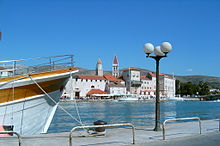
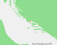
Geography Location Adriatic Sea Coordinates 43°30′N 16°17′E / 43.5°N 16.283°ECoordinates: 43°30′N 16°17′E / 43.5°N 16.283°E Area 28.8 km2 (11.12 sq mi) Highest elevation 218 m (715 ft) Highest point Rudine Country CroatiaCounty Split-Dalmatia Demographics Population 6,071 (as of 2001) Density 210.8 /km2 (546 /sq mi) Čiovo (pronounced [tʃîɔv̞ɔ]; Italian: Bua) is a small island located off the Adriatic coast in Croatia with an area of 28.8 km2 (length 15.3 km, width up to 3.5 km), population of 6,071 inhabitants (2001) and its highest peak is 218 m (Rudine).
The centre of the island has geographical coordinates 43°30′N 16°17′E / 43.5°N 16.283°E, and the annual rainfall is about 900 mm.
Contents
Geography
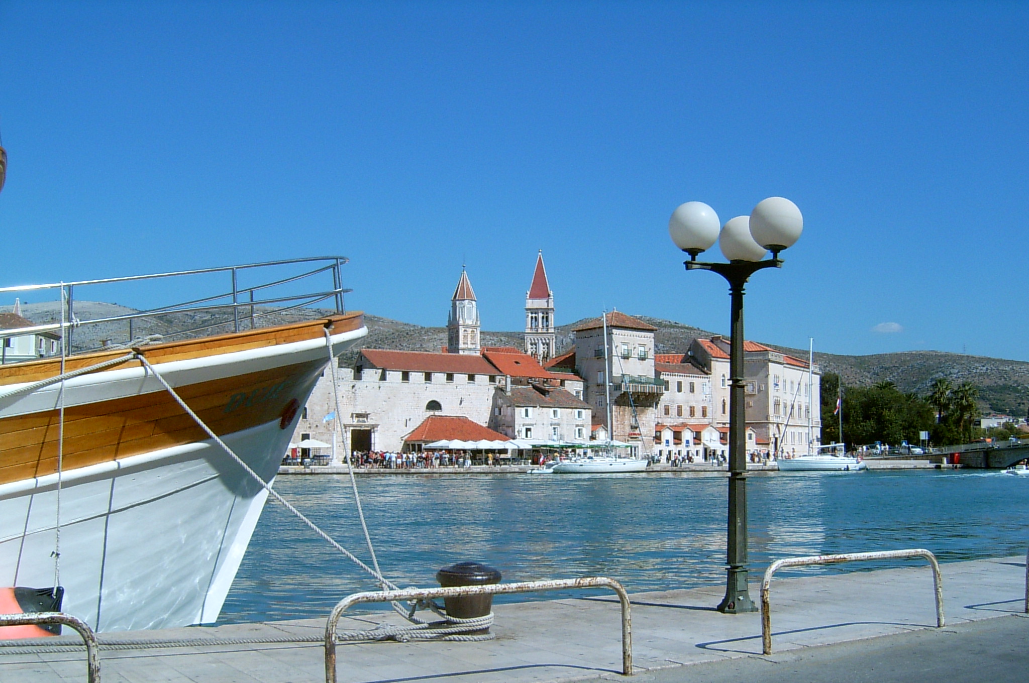
Čiovo is located in central Dalmatia, protecting the citiy of Trogir and Kaštela gulf. On its SE part it is only two km distant from the cape Marjan, on northern part it is connected to the mainland with a small bascule bridge in the old centre of Trogir, and actually Trogir spread itself on the island. Besides the part of Trogir, on the island there are several villages: Arbanija, Žedno, Okrug Gornji, Okrug Donji, Slatine and Prizidnica.
The vegetation is typically Mediterranean, consisting mainly in understory (holm oak, myrtle, wormwood, juniper etc.). On the northern side (exposed to the wind bura are forests of pine and cypress. Major crops include olives, figs, almonds, vines and citrus fruit.
History
In the Middle Ages, Čiovo had many villages and it was a place for lepers. Remainings of the pre-Romanesque church of St. Peter have been found near Slatine, in the Supetar cove. The medieval church of St. Maurice (Sv. Mavro) has been preserved in Žedno and the pre-Romanesque church of Our Lady near the Sea (Gospa pokraj mora). The population of Čiovo increased in the 15th century through the settlement of refugees who fled from the Turks.[1] Simultaneously, the suburban areas of Trogir also extended to Čiovo.
Heritage
The church and the Dominican monastery of the Holy Cross (Sv. Križ) (5 km from Trogir) were built in the 15th century by the masters Ivan Drakanović and Nikola Mladinov. In the Franciscan monastery of St. Anthony (Sv. Antun) There are a painting of Palma the Younger and a sculpture of St. Magdalene by Ivan Duknović. Along the coast is the church of St. Jerome. On the eastern coast, up the cliff is the nicely located hermitage church of Our Lady of Prizidnica. Along the south-western side of Čiovo, vis-a-vis the beach, is a small island called Fumija, with the remains of the late antique or early mediaeval church of St. Fumija and farm buildings of the Benedictine monks from Trogir.
The church in Prizidnice was built in 1546 by priest J. Strojdražić, the hermit of Prizidnice who had settled there years before. On the facade of the church there is an inscription in old Italian (italiano volgare) carved into the stone board:
- PRE ZORZI STOIDRAZIC VENE QUA
- IN EREMITORIO ED IFICHO QUESTO
- TEMPIO AD ONORE BEATE MARIE CONCEPCIONE
- MDXLVI
In translation: Priest J. Strojdražić comes here in hermit's residence and raises this temple on the honor of Blessed Maria of Conception in 1546. The sanctuary is situated in beautiful natural surroundings on the southern part of the island, on the stone cliffs beside the sea. The steep cliffs, blue sea, blossoming agaves and a lot of autochthonous plant species, beside the old convent and small church enriched with votive ships, make this place incredible.
It is 460 years old and many stories and legends are connected with the place itself, which elder people from Slatine will gladly share when you visit it....The religious tourism has been developed: pilgrims go on pilgrimage to the Our Lady of Prizidnice four times during the year: On Easter Monday and Whit Monday, on Immaculate Conception of Blessed Virgin Mary and Holy Name of Mary 's. Believers in large number go on a pilgrimage on Holy Name of Mary's when sanctuary is full of pilgrims not only from Slatine but from other surrounding places as well.
See also
References
External links
Adriatic islands of Croatia > 100 km2 10–100 km2 1–10 km2 Arta Velika · Biševo · Dolin · Drvenik Mali · Goli otok · Ilovik · Ist · Jakljan · Kakan · Kaprije · Katina · Koločep · Kurba Vela · Lavdara · Lavsa · Levrnaka · Lopud · Mali Brijun · Maun · Mrčara · Piškera · Planik · Plavnik · Premuda · Prežba · Prvić (Šibenik) · Rava · Rivanj · Šćedro · Sit · Smokvica Vela (Kornat) · Škarda · Škrda · Sušac · Susak · Svetac · Sveti Grgur · Sveti Klement · Tijat · Tun Veli · Vele Orjule · Vele Srakane · Veliki Brijun · Vrgada · Zeča · Zlarin · Zmajan · ZverinacInhabited islands of Croatia Biševo • Brač • Čiovo • Cres • Drvenik Mali • Drvenik Veliki • Dugi otok • Hvar • Ilovik • Ist • Iž • Kaprije • Koločep • Kornat • Korčula • Krapanj • Krk • Lastovo • Lopud • Lošinj • Male Srakane • Mljet • Molat • Murter • Olib • Ošljak • Pag • Pašman • Premuda • Prvić • Rab • Rava • Rivanj • Sestrunj • Silba • Šipan • Šolta • Susak • Ugljan • Unije • Vele Srakane • Vir • Vis • Vrgada • Žirje • Zlarin • ZverinacCategories:- Islands of Croatia
- Islands of the Adriatic Sea
- Split-Dalmatia County

Wikimedia Foundation. 2010.