Drvenik Mali (island)

Drvenik Mali (island)

Infobox Islands
name = Drvenik Mali


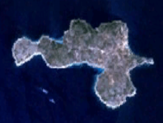
image caption = satellite image of Drvenik Mali
image size =
locator

native name =
native name link = Croatian
nickname =
location = Adriatic sea
coordinates =
archipelago =
total islands =
major islands =
area = 12.07 km²
highest mount =
elevation = 178 m
country = Croatia
country admin divisions title = County
country admin divisions = Split-Dalmatia
country capital city =
country largest city = Drvenik Mali
country largest city population =
country leader title =
country leader name =
population = 54
population as of = 2001
density =
ethnic groups =
additional info =

Drvenik Mali ("Zirona Piccola" in Italian) is an island in Croatian part of Adriatic Sea. It is situated in middle-Dalmatian archipelago, west of Drvenik Veliki, convert|8|nmi|km from Trogir [http://homes.point2.com/HR/Central-Dalmatia/Island-Drvenik-Mali/558397-Real-Estate.aspx Drvenik on Point2 Homes] ] . It's area is 12.07 km²hr icon [http://peljar.cvs.hr/show_place_info.php?id=212 First Croatian online peljar] ] , and it has population of 54 (as of 2001). [http://www.dzs.hr/Hrv_Eng/ljetopis/2005/00-sadrzaj.pdf Statistical yearbook for 2006 of Central bureau of statistics of Republic of Croatia] ] The coast is well indented and sea around the island is shallow, thus convenient for fishing. The highest peak is 178 metres high. Main industries are agriculture (mostly olives), fishing and tourism.

References

External links


Wikimedia Foundation. 2010.

Игры ⚽ Нужно сделать НИР?

Look at other dictionaries:

  • Drvenik Mali — Satellite image of Drvenik Mali …   Wikipedia

  • Drvenik Veliki — Satellite image of Drvenik Veliki Geography Location Adriatic Sea Coordinates …   Wikipedia

  • Drvenik — may mean: Drvenik a village in southern Dalmatia, Croatia Drvenik a village on island Drvenik veli Drvenik Veliki and Drvenik Mali two islands in central Dalmatia, Croatia This disambiguation page lists articles associated with the same title. If …   Wikipedia

  • Dolin (island) — For other uses, see Dolin. Dolin Geography Location Adriatic Sea Coordinates …   Wikipedia

  • Maun (island) — Maun is an island in the Adriatic Sea located southwest of Pag and northeast of Olib. Its area is 8.50 km2 (3.28 sq mi). References http://www.islands croatia.com/north adriatic islands/island maun 2/ Duplančić Leder, Tea; Ujević,… …   Wikipedia

  • D410 road (Croatia) — D410 state road Route information Length: 4.0 km (2.5 mi) Major junctions …   Wikipedia

  • Korčula — This article is about the Croatian island of Korčula. For the town of the same name, see Korčula (town). Korčula Korčula (town) …   Wikipedia

  • Mljet — Great Lake of Mljet Geography Location …   Wikipedia

  • Cres — This article is about the island in the Adriatic sea. For CRES steel, see stainless steel. Cres Filozići Geography …   Wikipedia

  • Murter — in 1995 Geography Location Adria …   Wikipedia

Share the article and excerpts

Direct link
Do a right-click on the link above
and select “Copy Link”