- D410 road (Croatia)
-
D410 state road
Route information Length: 4.0 km (2.5 mi) Major junctions From:  D8 in Split
To:  Split ferry port
Location Counties: Split-Dalmatia Major cities: Split Highway system State roads in Croatia
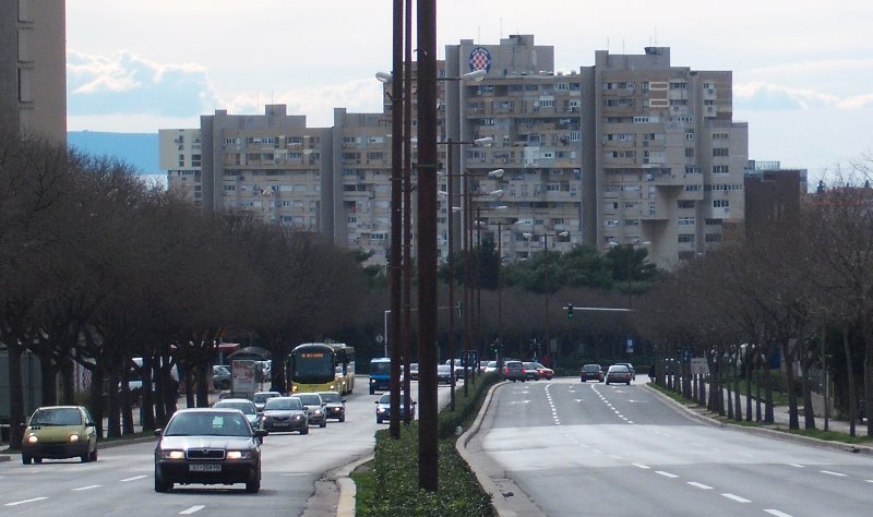
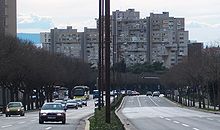 The D410 road in Split (Poljička)
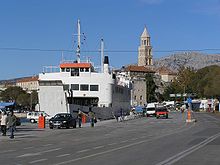 Split ferry port, at the western terminus of the D410 road
D410 branches off to the southwest from D8 in Split towards the Port of Split - ferry access to Supetar (D113), Bol and Milna on Brač Island, Stari Grad (D116) and Jelsa on Hvar Island, Vela Luka on Korčula Island (D118), Rogač on Šolta Island (D112), as well as to Vis (D117), Lastovo (D119), Drvenik Veli and Drvenik Mali islands. There is also an international ferry services to Ancona, Italy. The road is 4.0 km long.[1]
The road, as well as all other state roads in Croatia, is managed and maintained by Hrvatske ceste, state owned company.[2]
Contents
Traffic volume
D410 traffic is not counted directly, however Hrvatske ceste, operator of the road reports number of vehicles using ferry service flying from the Port of Split, accessed by the D410 road, thereby allowing the D410 traffic volume to be deduced.[3] Furthermore the D410 is a part of Split urban transportation system servicing a considerable urban traffic far exceeding the ferry traffic. Substantial variations between annual (AADT) and summer (ASDT) traffic volumes are attributed to the fact that the road serves as a connection carrying substantial tourist traffic to Split area islands, while the D8 and D1 state roads provide quick access to A1 motorway Dugopolje interchange.[4]
D410 traffic volume Road Counting site AADT ASDT Notes  D410
D410606 Split-Trogir-Drvenik Veli-Drvenik Mali 20 27 Traffic to the islands of Drvenik Veli and Drvenik Mali only. D410636 Split-Rogač 148 306 Traffic to the island of Šolta only. D410602 Split-Vis 115 280 Traffic to the island of Vis only. D410631 Split-Supetar 914 1,989 Traffic to the island of Brač only. D410635 Split-Stari Grad 380 932 Traffic to the island of Hvar only. D410604 Split-Hvar-Vela Luka-Lastovo 121 278 Traffic to the islands of Hvar, Korčula and Lastovo only. D41053 Split-Ancona 49 49* Traffic to Ancona, Italy only.[5] D410Split ferry port (total) 1,747 3,861 Total D410 traffic volume in Split ferry port. * There are no ASDT figures available for Split-Ancona line. AADT figure is used instead. Road junctions and populated areas
D410 junctions/populated areas Type Slip roads/Notes 
Split
D8 to Šibenik, Zadar and A1 motorway connection road (D1 expressway) (to the north) and Makarska (to the south). The eastern terminus of the road.
Split ferry port - ferry access[6][7] to Supetar (D113), Bol and Milna on Brač Island, Stari Grad (D116) and Jelsa on Hvar Island, Vela Luka on Korčula Island (D118), Rogač on Šolta Island (D112), as well as to Vis (D117), Lastovo (D119), Drvenik Veli and Drvenik Mali islands. There is also an international ferry services to Ancona, Italy. The western terminus of the road. Sources
- ^ "Decision on categorization of public roads as state roads, county roads and local roads" (in Croatian). Narodne novine. February 17, 2010. http://narodne-novine.nn.hr/clanci/sluzbeni/2010_02_17_410.html.
- ^ "Public Roads Act" (in Croatian). Narodne novine. December 14, 2004. http://narodne-novine.nn.hr/clanci/sluzbeni/2004_12_180_3130.html.
- ^ "Traffic counting on the roadways of Croatia in 2009 - digest" (in English). Hrvatske ceste. May 1, 2010. http://www.hrvatske-ceste.hr/WEB%20-%20Legislativa/brojenje-prometa/CroDig2009.pdf.
- ^ "Regulation on motorway markings, chainage, interchange/exit/rest area numbers and names" (in Croatian). Narodne novine. May 6, 2003. http://narodne-novine.nn.hr/clanci/sluzbeni/305463.html.
- ^ "More moderate sea transport in 2009" (in Croatian). Agencija za obalni linijski promet. February 16, 2010. http://www.agencija-zolpp.hr/tabid/1534/articleType/ArticleView/articleId/866/SKROMNIJI-PROMET-MOREM-U-2009.aspx.
- ^ "Jadolinija ferry service" (in English). May 11, 2010. http://www.jadrolinija.hr/default.aspx?lang=2.
- ^ "LNP ferry service schedule" (in English). May 11, 2010. http://www.lnp.hr/plovidbeni-red.aspx?l=2.
See also
- State roads in Croatia
- Hrvatske ceste
- Jadrolinija
Categories:- State roads in Croatia
- Split-Dalmatia County


Wikimedia Foundation. 2010.