- California State Route 76
-
State Route 76
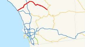
Route information Defined by S&HC § 376 Maintained by Caltrans Length: 52.628 mi[1] (84.70 km) Existed: 1964 state highway renumbering[citation needed] – present Major junctions West end:  I-5 in Oceanside
 I-15 near Pala
East end:  SR 79 near Lake Henshaw
Highway system State highways in California(list • pre-1964)
History • Unconstructed • Deleted • Freeway • Scenic←  SR 75
SR 75SR 77  →
→State Route 76 (SR 76) is a 52.32-mile (84.20 km) state highway in the U.S. state of California. It is an important east–west route in the North County region of San Diego County that begins in Oceanside near Interstate 5 and continues east past Interstate 15 to State Route 79. The section of the highway through Oceanside is an expressway; east of Oceanside, SR 76 is a two-lane highway, although there are plans for the expansion of much of the route.
Contents
Route description
From Interstate 5 to Interstate 15, SR 76 is part of the California Freeway and Expressway System,[2] although only the section through Oceanside is an expressway. SR 76 is eligible for the State Scenic Highway System,[3] but it is not officially designated as a scenic highway by the California Department of Transportation.[4] The expressway part of this highway is also named for Tony Zeppetella, an Oceanside police officer killed in the line of duty.[5]
State Route 76 begins at County Route S21 in Oceanside, the former routing of U.S. Route 101. It quickly has an interchange with Interstate 5, then becomes a four-lane expressway known as the San Luis Rey Mission Expressway. From I-5 to Mission Avenue, SR 76 parallels the San Luis Rey River until it passes by Oceanside Municipal Airport. During this stretch, SR 76 intersects Loretta Street, Canyon Drive, Benet Road, Airport Road, and Foussat Road. It then has an overpass over Mission Avenue and El Camino Real before intersecting Douglas Drive, the main road to the San Luis Rey gate of Camp Pendleton. After an intersection with Rancho Del Oro Road, SR 76 passes over Mission Avenue again before intersecting with Old Grove Road, Frazee Road, a turnoff into the Towne Center North shopping center, and College Boulevard. [6]
As it begins to enter rural Oceanside, SR 76 intersects with County Route S14 (South Santa Fe Avenue) a main road that travels into Vista, Guajome Lake Road (with access to Guajome County Park), and Melrose Drive. From Melrose Drive to Jeffries Ranch Road, the expressway narrows to two lanes. East of Jefferies Ranch Road, SR 76 remains a two-lane highway for the remainder of its route. However, construction is underway for the widening and alignment east from Jefferies Ranch Road to Olive Hill Road in Bonsall. This segment is scheduled to be complete by 2014, with widening to Interstate 15 scheduled to start by 2020. [6]
SR 76 intersects the southern segment of County Route S13 (East Vista Way) which also goes into Vista, and passes over the San Luis Rey River before going through Bonsall and intersecting Olive Hill Road. SR 76 then meets the northern segment of CR S13 (South Mission Road), heading north into Fallbrook; SR 76 is the primary road connecting the two halves of CR S13, but this portion of CR S13's routing is not signed. It is at this point when SR 76 becomes known as Pala Road. It intersects Gird Road south of Fallbrook before encountering the former routing of U.S. Route 395 and the current routing of Interstate 15 in the community of Pala Mesa Village. [6]
SR 76 then goes through Pala and the Pala Indian Reservation, passing by Pala Casino and intersecting County Route S16, the turnoff to the Pala Mission and Temecula. Continuing to parallel the San Luis Rey River, SR 76 passes by the Wilderness Gardens County Park before entering the community of Pauma Valley and meeting the southern terminus of CR S7 (Nate Harrison Grade), a dirt road leading into Palomar Mountain State Park. SR 76 intersects with the southern leg of County Route S6 (Valley Center Road), the turnoff to Valley Center and Escondido before passing through the small Yuima Indian Reservation. SR 76 then intersects with the northern leg of CR S6, the southern approach to the Palomar Observatory and Palomar Mountain State Park before passing through La Jolla Amago. It then briefly passes through the Cleveland National Forest before meeting the eastern terminus of County Route S7, which is the eastern approach to Palomar Mountain. Sr 76 then passes along the shores of Lake Henshaw before terminating at the intersection with State Route 79 at Morettis Junction, southeast of Lake Henshaw.[6]
History
SR 76 was originally designated as a state highway, and extended from U.S. 101 in Oceanside all the way to SR 79 near Lake Henshaw. [7] The road was constructed by 1930,[8] although it was not paved east of Pala.[9] However, it was not designated as Legislative Route 195 until 1935.[citation needed] SR 76 was fully signed by 1956.[10]
During the 1964 state highway renumbering, Legislative Route 195 was legally designated as State Route 76. The legal designation was updated to reflect the new construction of Interstate 5.[11]
Before 1994 all of SR 76 was a two-lane highway, running on Mission Avenue in Oceanside. A four lane expressway bypass of Oceanside was constructed beginning in 1994. The first four miles (from Interstate 5 to Mission Avenue east of Foussat Road) opened to traffic in 1996. The next stretch (from Mission Avenue to College Blvd.) opened in early 1999. The final stretch between College Blvd. and Jefferies Ranch Road was opened in late 1999. Because the expressway was constructed on top of Mission Avenue east of Old Grove Road, Mission Avenue was rerouted onto a new alignment that connected to Frazee Road. However, Mission Avenue is still fragmented today, and does not exist between Frazee Road and Jefferies Ranch Road, where the expressway ends.
Future
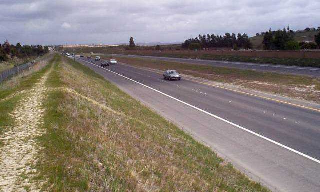
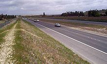 State Route 76 in Oceanside
There are plans to extend the expressway all the way to I-15. In March 2009, a new 1.3 mile realigned segment of State Route 76 opened east of I-15. Initially, only two lanes are open, with the other two lanes of this new four lane divided highway planned to open in September 2009. The purpose of this improvement is to reduce accidents on a stretch of road that now carries over 12,000 motorists per day. Much of this traffic is destined for either the Pala Indian casino or a new gravel quarry that was recently opened. The casino and quarry owners each paid for half of the new road. At this time, there are no plans to extend this improvement eastward to Pala. [12]
The city of Oceanside does have plans for grade-separated interchanges with College Boulevard and Melrose Drive, should the expressway through Oceanside need to be converted to a freeway.[13]
Major intersections
- Note: Except where prefixed with a letter, postmiles were measured in 1964, based on the alignment as it existed at that time, and do not necessarily reflect current mileage.
The entire route is in San Diego County.
Location Postmile
[1][14][15]Destinations Notes Oceanside R0.00  CR S21 (North Coast Highway)
Continuation beyond I-5 R0.00 I-5 (San Diego Freeway) – Los Angeles, San DiegoInterchange R3.75 Douglas Drive R6.21 College Boulevard R6.72  CR S14 (North Santa Fe Avenue) – Vista
Bonsall R9.49  CR S13 north (East Vista Way) / Old River Road – Vista
West end of CR S13 overlap 12.47 CR S13 south (Mission Road) – FallbrookEast end of CR S13 overlap R17.02 Old Highway 395 Former US 395 R17.30 I-15 (Escondido Freeway) – Riverside, San DiegoInterchange Pala 24.13  CR S16 (Pala Mission Road) – Pala, Temecula
Rincon 32.87  CR S6 south (Valley Center Road) – Valley Center, Escondido
West end of CR S6 overlap 38.25 CR S6 north (South Grade Road) – Palomar MountainEast end of CR S6 overlap 47.79  CR S7 (East Grade Road) – Palomar Mountain
Morettis Junction 52.32 SR 79 – Warner Springs, Santa Ysabel1.000 mi = 1.609 km; 1.000 km = 0.621 mi
Concurrency terminus • Closed/Former • Incomplete access • UnopenedReferences
- ^ a b California Department of Transportation, State Truck Route List (XLS file), accessed February 2008
- ^ CA Codes (shc:250-257)
- ^ CA Codes (shc:260-284)
- ^ "Officially Designated State Scenic Highways and Historic Parkways". California Department of Transportation. December 7, 2007. http://www.dot.ca.gov/hq/LandArch/scenic_highways/. Retrieved June 22, 2011.
- ^ [1]
- ^ a b c d Thomas Brothers (2009). San Diego County Street Atlas (Map).
- ^ "An act...relating to...the addition of certain highways to the State system.", 1933 chapter 767
- ^ Associated Oil Company (1930). Maps of California (Map).
- ^ Shell Oil Company (1932). California (Map).
- ^ Union Oil Company (1956). California Union Oil Road Map (Map). Cartography by Rand McNally Company.
- ^ "An act...relating to routes on the state highway system.", 1963 chapter 385
- ^ http://www.nctimes.com/articles/2009/03/26/news/inland/fallbrook/zdb7467b3843fcd178825757b00595d6a.txt
- ^ [2]
- ^ California Department of Transportation, Log of Bridges on State Highways, April 2008
- ^ California Department of Transportation, All Traffic Volumes on CSHS, 2005 and 2006
External links
Categories:- State highways in California
- Roads in San Diego County, California


Wikimedia Foundation. 2010.