- Staplehurst
-
Coordinates: 51°09′50″N 0°33′11″E / 51.164°N 0.553°E
Staplehurst 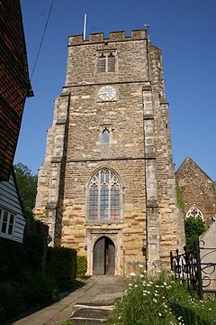
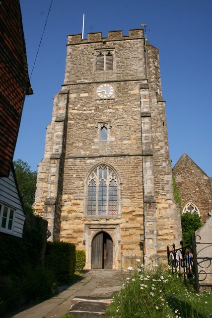
All Saints church
 Staplehurst
Staplehurst shown within KentPopulation 6,003 (2001)[1] District Maidstone Shire county Kent Region South East Country England Sovereign state United Kingdom Post town TONBRIDGE Police Kent Fire Kent Ambulance South East Coast EU Parliament South East England UK Parliament Maidstone and The Weald List of places: UK • England • Kent Staplehurst /ˈsteɪpəlhɜrst/ is a large village and civil parish, situated south of Maidstone in Kent, England. The name Staplehurst comes from the Saxon words staple (meaning post) and hurst (meaning wood or clearing in a forest). The village lies on the route of a Roman road, which is now incorporated into the course of the A229.
There are approximately 2,600 households and 6,000 residents, a population that brings the village on par with some small towns. However, Staplehurst lacks the large facilities, like a supermarket and leisure centre, that would enable it to be classified as a town. There are a number of local shops at The Parade, which lies roughly at the centre of the village. A number of public houses are situated in the village, including The Railway Tavern, The King's Head, The Bell Inn, and The Pride of Kent. The village also has a small library and a newly-built two million pound medical centre which contains numerous doctors and dentists. The building of the medical centre on the school field enabled the school to have a large sports hall built.
Contents
History
In the early 19th century, Staplehurst was often visited by invalids seeking recuperation, especially those from Romney Marsh and East Kent, apparently attracted by the purity of the air.[2]
The Staplehurst rail crash, in 1865,[3] is a significant event in the history of the village. Charles Dickens, who was on board, was affected by the incident for the rest of his life.[4][5]
In 2003, Staplehurst won the Kent Village of the Year Competition.[6]
Staplehurst was also the centre of police investigations following the Securitas depot robbery in 2006.[7][8]
Government
Staplehurst is governed by Staplehurst Parish Council, Maidstone Borough Council, and Kent County Council.
Culture and Community
Religion
The parish church, All Saints' Church, Staplehurst, is located at the highest point in the village. The village also has a United Reformed Church and a Free church.
Education
Staplehurst School, the village primary school, is located on Gybbon Rise, near the town centre shops. Around 440 pupils are taught in 18 classrooms.[9] The school was originally housed in the stone buildings off the A229 and moved to the new site when the population of the village grew in the 1980s. The old school then became the village community centre.
Transport
Staplehurst railway station is a busy station and is well-used by commuters working in London. The station is on the main line from Ashford International railway station to London Charing Cross and London Cannon Street, via Tonbridge. It is also the main station for commuters from Cranbrook, Hawkhurst, Sissinghurst, and other nearby villages. Before the completion of High Speed 1, the line was also used by Eurostar trains.
Notable Residents
Professional wrestler Desmond Wolfe (formerly Nigel McGuinness) is a former resident of Staplehurst.
References
- ^ "Staplehurst CP". Neighbourhood Statistics. http://www.neighbourhood.statistics.gov.uk/dissemination/LeadTableView.do?a=3&b=795506&c=Staplehurst&d=16&e=15&g=458914&i=1001x1003x1004&m=0&enc=1&dsFamilyId=781. Retrieved 2007-08-20.
- ^ Dearn, T.D.W. (1814). An Historical, Topographical and Descriptive Account of the Weald of Kent. Cranbrook: S. Reader. pp. 225.
- ^ Accident at Staplehurst on 9th June 1865, Railways Archive
- ^ PDF, Post Traumatic Culture, Injury and Interpretations in the Nineties, Kirby Farrell, JHU Press, 1998. P.8
- ^ Eyewitness: Charles Dickens survives a train crash 1865, My Time Machine
- ^ Staplehurst, Information Britian
- ^ Police scour Kent farm for clues to £53m robbery as gang's lorry traced, Rosie Cowen, The Guardian, 01-03-06
- ^ Securitas robbery: The investigation, BBC Website, 28-01-08
- ^ "Staplehurst School". http://www.staplehurstprimary.ik.org/p_About_Us.ikml. Retrieved 2011-02-18.
External links
- Staplehurst Parish Council Web Site
- All Saints' Church Staplehurst Web Site
- Staplehurst Free Church Web Site
- Staplehurst Cricket & Tennis Club
- Staplehurst Cricket & Tennis Club

Chainhurst Chart Sutton
Cross-at-HandSutton Valence
HawkenburyMarden 
Headcorn  Staplehurst

Curtisden Green
GoudhurstCranbrook Common Frittenden Staplehurst Locations in the
parish of StaplehurstBuildings Businesses Events Military People Towns and villages in the Maidstone borough of Kent, England 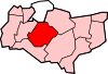 Allington · Barming · Bearsted · Bedmonton · Benover · Bexon · Bicknor · Boughton Green · Boughton Malherbe · Boughton Monchelsea · Boxley · Bredhurst · Broomfield · Caring · Chainhurst · Chart Sutton · Chegworth · Collier Street · Coxheath · Detling · Downswood · East Barming · East Farleigh · East Sutton · Fairbourne Heath · Frinsted · Grove Green · Harrietsham · Hawkenbury · Headcorn · Hollingbourne · Horden · Hucking · Hunton · Kingswood · Kit's Coty · Laddingford · Langley · Leeds · Lenham · Linton · Loose · Lordswood · Maidstone · Marden · Marley · Milebush · Nettlestead · Nettlestead Green · Otham · Otterden · Park Wood · Platt's Heath · Penenden Heath · Pollhill · Ringlestone (hamlet) · Ringlestone (suburb) · Sandling · Sandway · Shepway · Sutton Valence · Staplehurst · Stockbury · Teston · Thurnham · Tovil · Ulcombe · Walderslade · Weavering · West Farleigh · Wichling · Wormshill · Yalding
List of places in Kent Categories:- Maidstone (borough)
- Unreferenced Kent-related articles
- Kent


Wikimedia Foundation. 2010.