- Detling
-
Coordinates: 51°17′46″N 0°34′16″E / 51.296°N 0.571°E
Detling 
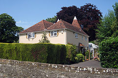
West Court Oast
 Detling shown within Kent
Population 777 (2001) OS grid reference TQ7958 Parish Detling District Maidstone Shire county Kent Region South East Country England Sovereign state United Kingdom Post town MAIDSTONE Postcode district ME14 Dialling code 01622 Police Kent Fire Kent Ambulance South East Coast EU Parliament South East England UK Parliament Faversham and Mid Kent List of places: UK • England • Kent Detling is a village and civil parish in the Borough of Maidstone in Kent, England. The parish is located on the slope of the North Downs, north east of Maidstone, and on the Pilgrims' Way.
The village, 4 miles (6.4 km) from Maidstone, is bypassed by the A249 road, although at one time all traffic passed through it. The Cock Horse Inn was used to stable additional horses when required to take heavily-laden coaches and wagons on the steep route up Detling Hill.
The village church is dedicated to Martin of Tours.
The disused airfield at the top of the hill was a Royal Navy Air Station during World War One, and an RAF station during World War Two. It was bombed by the Luftwaffe several times, with considerable loss of life. It's original area has been divided with some of the original hardstandings being used within a light industrial units area, part of the airfield is now farm land, and a significant part used by the Kent Showground - which hosts a number of annual events, such as the Kent County Show and the Detling Summer Conference, an event for evangelical Christians. A memorial in Detling Village commemorates the service personnel from the airfield. The village is also home to a Tudor gateway that has stood since the time of Henry VIII.
Detling Cricket Club have a ground on the Pilgrims' Way. They play on Saturdays and Sundays during the summer and hold practice sessions on Tuesday evenings. The team plays in the Kent Village League.
External links
Towns and villages in the Maidstone borough of Kent, England  Allington · Barming · Bearsted · Bedmonton · Benover · Bexon · Bicknor · Boughton Green · Boughton Malherbe · Boughton Monchelsea · Boxley · Bredhurst · Broomfield · Caring · Chainhurst · Chart Sutton · Chegworth · Collier Street · Coxheath · Detling · Downswood · East Barming · East Farleigh · East Sutton · Fairbourne Heath · Frinsted · Grove Green · Harrietsham · Hawkenbury · Headcorn · Hollingbourne · Horden · Hucking · Hunton · Kingswood · Kit's Coty · Laddingford · Langley · Leeds · Lenham · Linton · Loose · Lordswood · Maidstone · Marden · Marley · Milebush · Nettlestead · Nettlestead Green · Otham · Otterden · Park Wood · Platt's Heath · Penenden Heath · Pollhill · Ringlestone (hamlet) · Ringlestone (suburb) · Sandling · Sandway · Shepway · Sutton Valence · Staplehurst · Stockbury · Teston · Thurnham · Tovil · Ulcombe · Walderslade · Weavering · West Farleigh · Wichling · Wormshill · Yalding
List of places in Kent Categories:- Maidstone (borough)
- Villages in Kent
- Civil parishes in Kent
- Kent geography stubs
Wikimedia Foundation. 2010.

