- Collier Street
-
Coordinates: 51°11′22″N 0°27′16″E / 51.189460°N 0.454580°E
Collier Street 
 Collier Street
Collier Street shown within KentOS grid reference TQ714467 District Maidstone Shire county Kent Region South East Country England Sovereign state United Kingdom Post town Tonbridge Postcode district TN12 Dialling code 01892 Police Kent Fire Kent Ambulance South East Coast EU Parliament South East England UK Parliament Maidstone and The Weald List of places: UK • England • Kent Collier Street is a small village and civil parish in the Borough of Maidstone in Kent, England.
The village of Collier Street includes a Church, primary school, village hall, a small business estate and several farms. St. Margaret's church forms the centre of the village and was built between 1847 and 1849. It forms part of a benefice also comprising St. Mary's in Laddingford and St. Peter & St. Paul in Yalding. The three villages are located within three miles of each other but Collier Street, once part of Yalding's civil parish, has been part of its own parish since 1999. The civic or civil parish of Collier Street is governed by an elected parish council and was formed following a review by Maidstone Borough Council.
Having been first built in 1860, the Church of England primary school (St. Margaret's CEP) has been enlarged several times, now to accommodate more than 100 pupils. The closest comprehensive secondary school is Mascalls School [1] and there are several private schools in the area. Ex-pupils of St. Margaret's typically attend Mascalls or one of the various grammar schools in the nearest towns.
The village is in a rural location, but is close to the larger villages of Yalding, Marden and Horsmonden. The nearest towns are Paddock Wood, Maidstone, Tonbridge and Royal Tunbridge Wells. Collier Street itself comprises several older farms or substantial houses which existed before the majority of the village's housing was built in Victorian times, and parts of the village are still named for these houses, for example Spitzbrook and Mockbeggar. Just three old wealden roads make up the main part of the village, the main one of which has no official name but leads from Yalding in the north to Horsmonden in the south.
Historically, the village was situated in the middle of a hop-growing region. Its population swelled during the harvest as whole families, often from South-East London, arrived to help bring in the hops. However, as foreign hops became cheaper and easier to source nearly all the farms moved to other arable production. Today the fields are home to several fruit and vegetable crops including cherries, pears, strawberries and asparagus, but the area is known more for its apple orchards - the village has been colloquially known in the past as 'The village in an orchard'. Crow Plain Farm, to the north of the village, still grows a substantial volume of hops and has a fully functional gas-fired kiln used to dry the hops. Some of the old hoppers' huts can be found amongst the local orchards, fields and gardens.
The village has a population of less than 500 and is slightly unusual in having no shop, post office or pub. There were once at least two pubs in the village itself but these are now private residences. There are two pubs within a mile of the village however; The Woolpack in Benover to the north and The White Hart in Claygate to the south. There was once a shop at the far end of Haviker Street, but this wasn't re-instated after a fire in 1994.
Until recently, Collier Street was home to The Boarded Circuit, a Grasstrack motorcycle racing circuit which held two or three events each season, most notably the International Bonfire Burnup. The circuit was unique in being the only fully boarded permanent Grasstrack venue in the UK. The village is also only a few miles from the Beltring The Hop Farm Country Park, once a Whitbread farm and brewery, now a family attraction and concert venue.
External links
 Media related to Collier Street at Wikimedia Commons
Laddingford Hunton Chainhurst Paddock Wood 
Cross-at-Hand  Collier Street

Brenchley Horsmonden Marden Towns and villages in the Maidstone borough of Kent, England 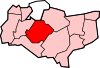 Allington · Barming · Bearsted · Bedmonton · Benover · Bexon · Bicknor · Boughton Green · Boughton Malherbe · Boughton Monchelsea · Boxley · Bredhurst · Broomfield · Caring · Chainhurst · Chart Sutton · Chegworth · Collier Street · Coxheath · Detling · Downswood · East Barming · East Farleigh · East Sutton · Fairbourne Heath · Frinsted · Grove Green · Harrietsham · Hawkenbury · Headcorn · Hollingbourne · Horden · Hucking · Hunton · Kingswood · Kit's Coty · Laddingford · Langley · Leeds · Lenham · Linton · Loose · Lordswood · Maidstone · Marden · Marley · Milebush · Nettlestead · Nettlestead Green · Otham · Otterden · Park Wood · Platt's Heath · Penenden Heath · Pollhill · Ringlestone (hamlet) · Ringlestone (suburb) · Sandling · Sandway · Shepway · Sutton Valence · Staplehurst · Stockbury · Teston · Thurnham · Tovil · Ulcombe · Walderslade · Weavering · West Farleigh · Wichling · Wormshill · YaldingCategories:
- Maidstone (borough)
- Villages in Kent
- Civil parishes in Kent


Wikimedia Foundation. 2010.