- Dering Harbor, New York
-
Dering Harbor, New York — Village — 

 Dering Harbor, New York
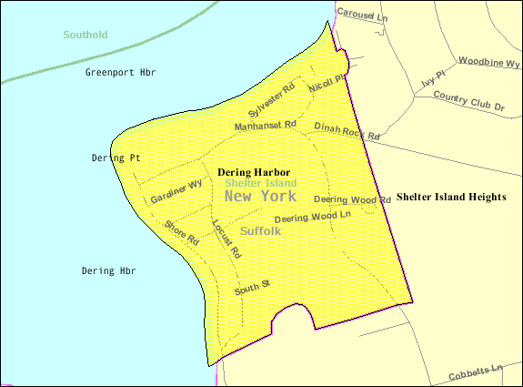
Coordinates: 41°5′35″N 72°20′43″W / 41.09306°N 72.34528°WCoordinates: 41°5′35″N 72°20′43″W / 41.09306°N 72.34528°W Country United States State New York County Suffolk Area – Total 0.3 sq mi (0.7 km2) – Land 0.2 sq mi (0.6 km2) – Water 0.0 sq mi (0.0 km2) Elevation 7 ft (2 m) Population (2000) – Total 13 – Density 54.1/sq mi (20.9/km2) Time zone Eastern (EST) (UTC-5) – Summer (DST) EDT (UTC-4) FIPS code 36-20379 GNIS feature ID 0948345 Dering Harbor is a village in the Town of Shelter Island, Suffolk County, New York, in the U.S. It is located on the north side of the island of Shelter Island, east of the hamlet of Shelter Island Heights. As of the 2000 census, the village population was 13.
Contents
Geography
Dering Harbor is located at 41° 5' 35" North, 72° 20' 43" West (41.093155, -72.345242)[1]. According to the United States Census Bureau, the village has a total area of 0.2 square miles (0.52 km2), of which, 0.2 square miles (0.52 km2) of it is land and 4.00% is water.
Demographics
As of the census[2] of 2000, there were 13 people, 6 households, and 3 families residing in the village. The population density was 54.1 people per square mile (20.9/km²). There were 32 housing units at an average density of 133.2 per square mile (51.5/km²). The racial makeup of the village was 92.31% White and 7.69% Native American.
There were 6 households out of which 16.7% had children under the age of 18 living with them, 50.0% were married couples living together, and 50.0% were non-families. 33.3% of all households were made up of individuals and 16.7% had someone living alone who was 65 years of age or older. The average household size was 2.17 and the average family size was 3.00.
In the village the population was spread out with 15.4% under the age of 18, 23.1% from 18 to 24, 7.7% from 25 to 44, 30.8% from 45 to 64, and 23.1% who were 65 years of age or older. The median age was 46 years. For every 100 females there were 116.7 males. For every 100 females age 18 and over, there were 120.0 males.
The median income for a household in the village was $33,750, and the median income for a family was $98,750. Males had a median income of $36,250 versus $0 for females. The per capita income for the village was $43,185. None of the population and none of the families were below the poverty line.
References
- ^ "US Gazetteer files: 2010, 2000, and 1990". United States Census Bureau. 2011-02-12. http://www.census.gov/geo/www/gazetteer/gazette.html. Retrieved 2011-04-23.
- ^ "American FactFinder". United States Census Bureau. http://factfinder.census.gov. Retrieved 2008-01-31.
External links
Town of Shelter Island, New York County Villages Dering HarborHamlets Website: shelter-island.org/Categories:- Shelter Island (town), New York
- Villages in New York
- Populated places in Suffolk County, New York

Wikimedia Foundation. 2010.