- Chama, New Mexico
-
Chama, New Mexico — Village — Cumbres & Toltec train in downtown Chama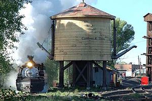 Location of Chama, New Mexico
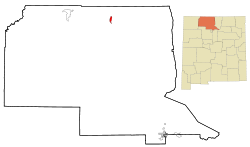
Coordinates: 36°53′41″N 106°35′4″W / 36.89472°N 106.58444°WCoordinates: 36°53′41″N 106°35′4″W / 36.89472°N 106.58444°W Country United States State New Mexico County Rio Arriba Government – Mayor Archie Vigil Area – Total 2.6 sq mi (6.6 km2) – Land 2.6 sq mi (6.6 km2) – Water 0.0 sq mi (0.0 km2) Elevation 7,871 ft (2,399 m) Population (2000) – Total 1,199 – Density 467.9/sq mi (180.6/km2) Time zone Mountain (MST) (UTC-7) – Summer (DST) MDT (UTC-6) ZIP code 87520 Area code(s) 575 FIPS code 35-13970 GNIS feature ID 0902207 Website http://chamavillage.com/ Chama is a village in Rio Arriba County, New Mexico, United States. The population was 1,199 at the 2000 census. It is a small village, but tourism is starting to help the town's economy[further explanation needed].
Contents
Geography
Chama is located at 36°53′41″N 106°35′4″W / 36.89472°N 106.58444°W (36.894777, -106.584406),[1] on the Rio Chama. According to the United States Census Bureau, the village has a total area of 2.6 square miles (6.7 km2), all of it land.
Transportation heritage
Chama is the western terminus of the Cumbres and Toltec Scenic Railroad, a steam-driven, narrow gauge heritage railway which carries visitors to and from Osier, CO and Antonito, CO during the summer months. It is the remaining 64 mile portion of the Denver & Rio Grande Railroad's San Juan Extension built in the 1880s between Alamosa, CO and Durango, CO. The route was abandoned in the late 1960s and the tracks from Chama westward to Durango were torn up soon afterwards.
Demographics
As of the census[2] of 2000, there were 1,199 people, 467 households, and 312 families residing in the village. The population density was 467.9 people per square mile (180.8/km²). There were 601 housing units at an average density of 234.5 per square mile (90.6/km²). The racial makeup of the village was 67.56% White, 1.58% African American, 2.67% Native American, 0.08% Asian, 25.10% from other races, and 3.00% from two or more races. Hispanic or Latino of any race were 71.23% of the population.
There were 467 households out of which 30.8% had children under the age of 18 living with them, 49.5% were married couples living together, 12.0% had a female householder with no husband present, and 33.0% were non-families. 26.3% of all households were made up of individuals and 8.8% had someone living alone who was 65 years of age or older. The average household size was 2.57 and the average family size was 3.13.
In the village the population was spread out with 26.6% under the age of 18, 6.7% from 18 to 24, 26.3% from 25 to 44, 28.2% from 45 to 64, and 12.3% who were 65 years of age or older. The median age was 38 years. For every 100 females there were 95.9 males. For every 100 females age 18 and over, there were 90.1 males.
The median income for a household in the village was $30,513, and the median income for a family was $31,983. Males had a median income of $27,167 versus $20,054 for females. The per capita income for the village was $16,670. About 11.9% of families and 17.9% of the population were below the poverty line, including 28.6% of those under age 18 and 13.7% of those age 65 or over.
See also:
- Chama, Colorado
- Rio Chama (Rio Grande)
- Cumbres Pass
- San Juan Mountains
- San Juan Express
References
- ^ "US Gazetteer files: 2010, 2000, and 1990". United States Census Bureau. 2011-02-12. http://www.census.gov/geo/www/gazetteer/gazette.html. Retrieved 2011-04-23.
- ^ "American FactFinder". United States Census Bureau. http://factfinder.census.gov. Retrieved 2008-01-31.
External links
Municipalities and communities of Rio Arriba County, New Mexico City 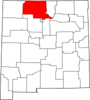
Village Chama
CDPs Alcalde | Chimayo‡ | Dulce | San Juan | Santa Clara Pueblo
Unincorporated
communitiesAbiquiú | Dixon | El Rito | Embudo | Hernandez | Navajo City | Ohkay Owingeh | Ojo Sarco | San Lorenzo | Tierra Amarilla | Truchas
Ghost towns Hopewell | Sublette
Indian reservation Footnotes ‡This populated place also has portions in an adjacent county or counties
Categories:- Populated places in Rio Arriba County, New Mexico
- Villages in New Mexico
- Populated places in New Mexico with Hispanic majority populations
- Railway stations in New Mexico


Wikimedia Foundation. 2010.