- Câmara de Lobos
-
Câmara dos Lobos Municipality (Concelho)  Câmara de Lobos, looking towards Pico da Torre, showing some houses and artesnal port
 Flag
Flag Coat of arms
Official name: Concelho da Câmara de Lobos Name origin: lobos, from lobos-marinhos, Portuguese for sea-lions Country  Portugal
Autonomous Region  Madeira
Island Madeira Municipality Câmara de Lobos Civil Parishes Câmara de Lobos, Curral das Freiras, Estreito de Câmara de Lobos, Jardim da Serra, Quinta Grande Landmark Pico da Torre Center Boca dos Namorados - elevation 1,044 m (3,425 ft) - coordinates 32°41′43″N 16°58′41″W / 32.69528°N 16.97806°W Lowest point Sea level - location Atlantic Ocean - elevation 0 m (0 ft) Area 51.82 km2 (20 sq mi) Population 34,614 (2001) Density 667.96 / km2 (1,730 / sq mi) Settlement c. 1419 - Municipality 4 October 1835 - City 3 August 1996 LAU Concelho/Câmara Municipal - location Praça da Autonomia, Câmara de Lobos, Madeira President Arlindo Pinto Gomes (PSD) Municipal Chair Rui Agostinho Gouveia Fernandes (PSD) Timezone WET (UTC0) - summer (DST) WEST (UTC+1) ISO 3166-2 code PT- Postal Zone 9304-001 Câmara de Lobos Area Code & Prefix (+351) 291 XXX XXX Demonym Madeirense; Câmara-lobense Patron Saint São Sebastião Municipal Address Praça da Autonomia
304-001 Câmara de LobosMunicipal Holidays 16 October  Administrative location of the municipality of Câmara de Lobos in the archipelago of Madeira
Wikimedia Commons: Câmara de Lobos Website: http://www.cm-camaradelobos.pt Statistics from INE (2001); geographic detail from Instituto Geográfico Português (2010) Câmara de Lobos (Portuguese pronunciation: [ˈkɐmɐɾɐ ðɨ ˈloβuʃ]; literally, Portuguese: chamber of the wolves is a municipality, parish and city in the south-central coast of the island of Madeira. A suburb of the, much larger, capital, it is nonetheless one of the larger population centres and extension of the economy of Funchal.
Contents
History
The location of the modern town is believed to be the original landing point for the Portuguese discoverer João Gonçalves Zarco, who is credited with the discovery of the Madeira Islands. When the explorer disembarked in this area (1419), he observed a thin cliff that extended into the ocean, and another cliff face that formed an amphitheatre-like harbour that could shelter ships from Atlantic storms. There Zarco and his men also found a large colony of marine animals that would become the reason for naming this area Câmara de Lobos.. The name, lobos, is a Portuguese derivation for sea-lions (Portuguese: lobos-marinhos), which were the animals discovered by Zarco and his men in the sheltered bay. Because of the large colony of these animals, the area was baptised câmara dos lobos.[1] This was a pejorative term, since câmara is the Portuguese word for municipal chamber (sometimes erroneously referred to as the city hall or city council), and the sailors named the area, literally as, the Municipal chamber of [the place where there are] Sea-Lions. Today, the species of monk seals (Latin: monachus monachus) are rare, being an animal common to the Mediterranean, but today confined to a small colony on the Desertas Islands.[2]
The municipality was created by ministerial decree on 25 May 1835, and invested in its executive on the 4 October 1835. Initially, this administrative division included the parishes of Câmara de Lobos, Curral das Freiras, Estreito de Câmara de Lobos and Campanário, all territorial parts of the Funchal. With many alterations, the newly constituted municipality of Câmara de Lobos operated with those parishes as its core, until Quinta Grande was constituted from sites in the parishes of Campanário and Câmara de Lobos, but maintaining its total area. On 6 May 1914, Campanário is deannexed to the newly created municipality of Ribeira Brava, and on 5 July 1996, the parish of Jardim da Serra was constituted from the higher altitude localities of Estreito de Câmara de Lobos.
On 15 September 1994, the parish of Estreito de Câmara de Lobos was elevated to the status of town, while two years later, on 3 August 1996, the village of Câmara de Lobos attained the status of city.
Geography
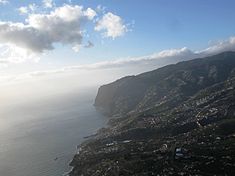 An areial view of the built-up areas of Câmara de Lobos along the coast, with the steep cliffs of Cabo Girão in the distance
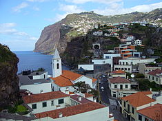 The main settlement of Câmara de Lobos, and first area settled by colonists to this area
Câmara de Lobos is the second largest city by population in Madeira with the largest (45%) contribution of youth under 25 years. Located within the metropolitan zone of Funchal, it is limited to the east by Funchal (through the parish of Estreito de Câmara de Lobos); to the west by the municipality of Ribeira Brava and the steep cliffs of Cabo Girão (one of the highest cliffs in Europe: 580 meter elevation); and north by the municipalities of Santana and São Vicente (and the mountains of Pico de Arieiro); while fronting the Atlantic Ocean to the south (except an area in the southwest near Quinta Grande (Fajã dos Padres) whose coast is part of the neighbouring parish of Campanário in Ribeira Brava
The decree of 1955 (No.40.221/5 July 1955) defines these limits more explicitly. but allows for interpretations:
- "In the north, from Pico do Arieiro, the municipal limit follows the line from the heights defined by Pedra Rija, Pico do Cidrão, Pico do Gato, Pico das Torres, Pico da Cágada, Pico Ruivo de Santana, Pico da Lapa da Cadela, Pico do Coelho, Pico das Eirinhas, Pico da Laje, Pico das Torrinhas, Pico Casado and Pico do Jorge. On the west, follow Pico do Jorge along a line in the altitudes specified by the Pico Arranha-Mata, Pico do Cerco, Pico Grande, Pico do Serradinho, Boca do Paço de Aires, Boca dos Corgos, Alto dos Aviceiros, Lombo do Covão, or Estrebaria, Pico do Trevo, Eira das Moças and Pico da Cruz, where they follow the road of Achada in Campanário until Vera Cruz, continuing through the escarpment of Partilha until an escarpment overlooing the sea, conforming to demarkations signed by cadastral sevices. To the south, the municipality is limited by the foremetioned escarpment until the mouth of the Ribeira da Quinta Grande and then by the coast line until the ravine in Socorridos, but not including the Fajã dos Padres. The east corresponds to the western limit of the municipality of Funchal, or specifically the line that exits Pico do Serrado and follows Lombo da Partilha until the confluence of the ravine of Eiroses and Socorridos, which serves as the municipalities limit until the ocean."[3]
Human geography
Population of
Câmara de Lobos
(1849 - 2008)Year Pop. ±% 1849 12,391 — 1900 17,468 +41.0% 1930 21,806 +24.8% 1960 29,759 +36.5% 1981 31,035 +4.3% 1991 31,476 +1.4% 2001 34,614 +10.0% 2008 36,119 +4.3% The municipality of Câmara de Lobos, in accord with the 2001 census, has a population of 30,814, while its resident population is 31,476 inhabitants (47% to 53%, male to female composition). While 22.7% are seniors (the lowest percentage in Maderia), its active population represents 10,986 of the population.
There are five parishes that constitute the municipality of Câmara de Lobos:
- Câmara de Lobos - The central urbanized area of Lobos (an area of 7.62 km²) is primarily residential and commercial: the parish population is approximately 16,842 inhabitants (about 48%) of the entire municipality, but second-most dense freguesia (English: civil parish) on the island. This core parish, is boxed in by Funchal (to the east), Quinta Grande (in the west) and Estreito de Câmara de Lobos (to the north). Many of these areas are highly development housing units, constructed during the late 20th Century, during the extensive growth in tourism and financial services on the island. Farmlands, which located in northern tracts have since given way to residential and commercial businesses.
- Curral das Freiras
- Estreito de Câmara de Lobos
- Jardim da Serra
- Quinta Grande
Twin towns — Sister cities
See also: List of twin towns and sister cities in PortugalCâmara de Lobos is twinned[4] with:
Economy
Although agriculture and fishing are still considered the primary sources of income, the area has grown as an extension of the tourism industry in the neighboring parishes. Its local development prospects are tied to the growing tourist market, while for six centuries of history it has been associated with the fishing and agriculture, in particular bananas and other fruits common to the island. Further, Madeira Wine, an important industry on the island, continues to drive the cultivation of local vineyards.
References
- Notes
- ^ Câmara Municipal (2011). "Lobo Marinho" (in Portuguese). Câmara de Lobos: Câmara Municipal da Câmara de Lobos. http://www.cm-camaradelobos.pt/Lobo_Marinho-1073.aspx. Retrieved 2011-02-25.
- ^ Although known as a sea-lion by the early sailors because of its vocalizations, the monk seal is recognized for a wrinkle on its neck, that appears as the hood of a monk, as well as its solitary habits.
- ^ Silva Freitas, Manuel Pedro da (2011). "Área e limites geográficos do concelho de Câmara de Lobos [Area and Geographic Limits of the Municipality of Câmara de Lobos]" (in Portuguese). Câmara de Lobos (Madeira), Portugal: Câmara de Lobos Dicionário Corográfico. http://www.concelhodecamaradelobos.com/. Retrieved 2011-02-25.
- ^ "Geminações da RAM [Twin Cities of the Autonomous Region of Madeira]" (in Portuguese). Funchal (Madeira), Portugal]]: Diário de Notícias. 2009. http://www.dnoticias.pt/default.aspx?file_id=dn04010201270709. Retrieved 2011-02-23.
External links
Madeira Island Calheta · Câmara de Lobos · Funchal · Machico · Ponta do Sol · Porto Moniz · Ribeira Brava · Santa Cruz · Santana · São Vicente

Porto Santo Island Porto SantoCategories:- Cities in Portugal
- Geography of Madeira
- Municipalities of Madeira
- Madeira Island


Wikimedia Foundation. 2010.