- Curral das Freiras
-
Curral das Freiras Civil Parish (Freguesia) 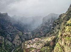 The hidden shangra-la of Curral das Freiras, nestled within the valley walls of the interior mountain range
Official name: Freguesia do Curral das Freiras Name origin: curral das freiras Portuguese compound phrase for valley of the nuns Nickname: Valley of the Nuns Country  Portugal
Region  Madeira
Island Madeira Municipality Câmara de Lobos Center Curral das Freiras - elevation 461 m (1,512 ft) - coordinates 32°43′12″N 16°58′11″W / 32.72°N 16.96972°W Length 7.65 km (5 mi), Southwest-Northeast Width 5.67 km (4 mi), Northwest-Southeast Area 25.03 km2 (10 sq mi) Population 1,673 (2001) Density 66.84 / km2 (173 / sq mi) Settlement c. 1462 - Parish c. 1780 - Civil Parish 17 March 1790 LAU Freguesia/Junta Freguesia - location Estrada Cónego Camacho, Curral das Freiras, Câmara dos Lobos President Junta Adelino Norberto de Sá Santos (PPD-PSD) President Assembleia Gregório Reis Fernandes Canhas (PPD-PSD) Timezone WET (UTC0) - summer (DST) WEST (UTC+1) ISO 3166-2 code PT- Postal Zone 9030-319 Curral das Freiras Area Code & Prefix (+351) 291 XXX XXX Demonym Madeirense Patron Saint Nossa Senhora do Livramento Parish Address Estrada Cónego Camacho, 7B
9030-319 Curral das Freiras
 Location of the parish seat of Curral das Freiras in the municipality of Câmara de Lobos, island of Madeira
Wikimedia Commons: Curral das Freiras Website: http://www.jf-curraldasfreiras.pt/ Statistics from INE (2001); geographic detail from Instituto Geográfico Português (2010) Curral das Freiras (English: Corral of the Nuns), is a civil parish in the municipality of Câmara de Lobos in the Portuguese archipelago of Madeira. In 2001 the popylation was just over 1673 residents, in an area that covers 25.07 km² of the interior mountain range of the island, in the shadow of Pico do Arieiro and Pico Ruivo. One of the more distant locations from the municipal seat of Câmara de Lobos, it is very isolated from other communities by the cliffs and peaks that surround its central valley.
Contents
History
Initially, during its early settlement access to the valley of Curral was difficult, and was only attempted by semi-nomadic shepards, or slaves who gained their emancipation or escaped from servitude. These distant peoples built small homes, and a small nucleus developed around the end of the 15th century, which became legally constituted. More permanent residents began to dwell in the valley shortly after, even as the area was little developed.
The settlement was part of the dominion of João Gonçalves Zarco, who granted its use for cultivation, around 1462 to João Ferreira and his wife Branca Dias; these settlers later donated their lands to their grand-child Branca Teixeira, on 22 August 1474. On 11 September 1480, the lands were, once again, sold to the second Captain-Donatório, João Gonçalves da Câmara (Zarco´s son), who in turn donated it the Convento of Santa Clara in the name of his daughter Elvira and Joana, who were initiatants at the convent. During early colonization, the settlement was simply known as Curral or Curral da Serra (English: corral or English: corral of the mountains), because it was known for its extensive pasture-lands, used for grazing cattle and small herds (sheep and goats). The name was subsequently altered, when these lands became the property of the nuns of the Convent of Santa Clara (between 1492 and 1497). There is also some discrepancy; others credit the name change after 1566, when the nuns of the Convent took refuge on these properties, during the French privateer attack and sack of Funchal.
The lands of Curral das Freiras were part of the parish of Santo António, but, owing to its extreme isolation from this ecclesiastical seat, the religious parish of Curral das Freiras was instituted in 1780. Later, on 17 March 1790, by regal charter (from Queen Maria I, Curral das Freiras became an independent parish, separating from Santo António.
Geography
Situated in a profound valley, and encircled by steep mountain slopes, the parish of Curral das Freiras is located 29 kilometres from the municipal seat of Câmara de Lobos. Most of the buildings in the parish overlook the main valley, with the steep hillsides encircling the parish used for the cultivation of cherries and grapes used in the production of Madeira wine. Curral das Freiras has a school, a church and a square (Portuguese: praça).
Culture
The parishes patron seat is Nossa Senhora do Livramento (English: Our Lady of Aleviation), and annually the parish celebrates a festival in Her honour on the last Sunday of August.
Gallery
-
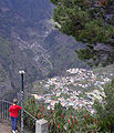
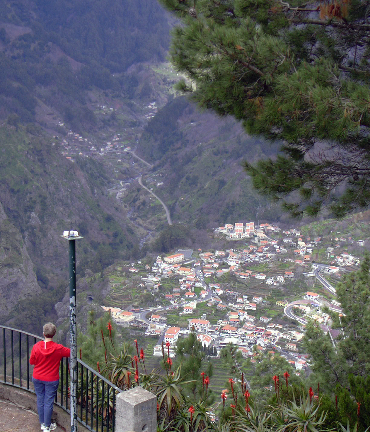
View of Curral das Freiras from Eira do Serrado
-
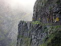
Old road to Curral das Freiras
Categories:- Madeira geography stubs
- Parishes of Câmara de Lobos (Madeira)
-


Wikimedia Foundation. 2010.