- New Mexico State Road 4
-
State Road 4 Route information Maintained by NMDOT Length: 64.1 mi[1] (103.2 km) Major junctions West end:  US 550 in San Ysidro
To:  NM 502 near Los Alamos
Highway system State Roads in New Mexico
SR • Minor SR • US←  NM 3
NM 3NM 6  →
→New Mexico State Road 4 is a state highway in New Mexico, United States of America. It is significant as the main access route (in conjunction with New Mexico State Road 501 and New Mexico State Road 502) connecting the remote town of Los Alamos, Los Alamos National Laboratory, and Bandelier National Monument to other, more major highways in New Mexico. Its total length is approximately 64 miles (103 km).
Contents
Route description
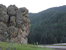
An outcropping in the Valles Caldera along the highway
New Mexico Route 4's western terminus is in the small town of San Ysidro, at U.S. Route 550. The route passes through Jemez Pueblo and Jemez Springs as it climbs steeply into the Jemez Mountains and Santa Fe National Forest, and skirts the southern boundary of Valles Caldera National Preserve. On the east side of the Jemez Mountains, it descends even more steeply, on a series of hairpin turns offering spectacular views into Frijoles Canyon in Bandelier National Monument, to a junction with NM 501 (NM 502 in some references, but NM 501 is correct) leading east into the town of Los Alamos. NM 4 itself continues past the main entrance to Bandelier and several Los Alamos National Laboratory sites, as well as the town of White Rock, to another junction with NM 502 east of Los Alamos, where the route ends. The continuation of NM 502 to Pojoaque was formerly designated as NM 4 as well.
In contrast to several other state highways in northern New Mexico, New Mexico Route 4 is paved for its entire length. It is predominantly a 2-lane road, with passing lanes in several places in the mountains. A short section near White Rock is 4-lane. Speed limits on most of the highway are 50 or 55 miles per hour (mph), although the tight curves make it dangerous to maintain maximum speed in many sections. Speed limits are lower near and through the towns.
The coniferous forest traversed by Route 4 in its upper regions is prone to severe forest fires, several of which have burned up to the highway.[2] Unfortunately, the highway is too narrow to serve as an effective firebreak, and such devastating fires as the 1977 La Mesa Fire and 2000 Cerro Grande Fire, the most severe forest fire in the state's history, have jumped the road to destroy forests, and habitations, on both sides of the road—in the case of the Cerro Grande Fire, into the upper reaches of Frijoles Canyon, contributing significantly to the magnitude of the disaster caused by the fire.[3]
National Scenic Byway
New Mexico Route 4 forms the main artery of the Jemez Mountain Trail National Scenic Byway.[4] The Byway includes short excursions on New Mexico State Roads 502, 126, and 290. Notable points of interest on the NM 4 section of the Byway include:
- Jemez Pueblo;
- The red rock of Cañon de San Diego;
- The Jemez River, with numerous protected areas affording access for fishing;
- Jemez State Monument, protecting both Puebloan ruins and ruins of a mission constructed by 16th-century Spanish explorers;
- Jemez Falls, a 70-foot (21 m)-high waterfall reached by a short hiking trail from a turnoff;
- Valles Caldera National Preserve;
- Bandelier National Monument, with hiking and Nordic skiing trails to Frijoles Canyon, Cerro Grande (highest summit in the monument, at 10,199 feet), and the Tsankawi outlier reachable from trailheads at turnouts.[5]
References
- ^ New Mexico Department of Transportation. "NMDOT Highway Log". http://www.nmshtd.state.nm.us/upload/images/CHDB/State%20Routes.pdf. Retrieved September 1, 2007.
- ^ Wildfire Alternatives (WALTER) Project, University of Arizona. "Jemez Fire History". http://walter.arizona.edu/overview/study_areas/jemez_fire_history.asp. Retrieved December 25, 2007.
- ^ General Accounting Office. "T-RCED-00-257 Fire Management: Lessons Learned From the Cerro Grande Fire". http://www.gao.gov/new.items/rc00257t.pdf. Retrieved December 29, 2007.
- ^ State of New Mexico, Tourism Department. "Jemez Mountain Trail National Scenic Byway". http://www.nmtourism.org/place/loc/favorites/page/DB-place/category/158/place/640.html. Retrieved December 25, 2007.
- ^ National Park Service. "Short Trails at Bandelier National Monument". http://www.nps.gov/band/planyourvisit/short-trails.htm. Retrieved December 25, 2007.
External links
Categories:- Western United States road stubs
- Jemez Mountains
- State highways in New Mexico
- Transportation in Sandoval County, New Mexico
- Transportation in Los Alamos County, New Mexico
- Transportation in Santa Fe County, New Mexico
Wikimedia Foundation. 2010.


