- New Mexico State Road 9
-
State Road 9
Route information Maintained by NMDOT Length: 109.154 mi[1] (175.666 km) Major junctions west end:  NM 80 north of Rodeo
east end: CR A003 at the Doña Ana county line Location Counties: Hidalgo, Grant, Luna Highway system State Roads in New Mexico
SR • Minor SR • US←  NM 8
NM 8I-10  →
→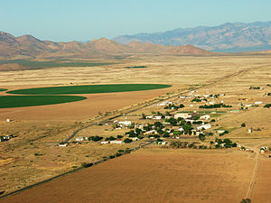 West looking view, (Animas & north Animas Valley), of State Road 9, Chiricahua Mountains massif, of Arizona on horizon. (north perimeter of New Mexico Bootheel)
State Road 9 (NM 9) is a 109.154-mile (175.666 km) long state road in the U.S. state of New Mexico. The highway spans Hidalgo, Grant, and Luna counties from NM 80 to CR A003 at the Doña Ana county line.
Route description
The highway's western terminus is at New Mexico State Road 80 north of Rodeo, in the San Simon Valley close to the border to Arizona. The route then climbs through Antelope Pass, a gap in the Peloncillo Mountains, into the Animas Valley where it intersects with NM 338 in the town of Animas. A few miles east of Animas, the road again climbs and crosses the Continental Divide the first of three times, then intersects with NM 113 (which goes northbound to I-10). Continuing east, the road crosses the Continental Divide twice in less than two miles (3 km), then descends to the Hachita Valley. In Hachita, the road intersects first with NM 146 (which goes northbound to I-10) in the small village of Hachita, then with NM 81 (which goes south to Antelope Wells, and into Mexico). From Hachita, NM 9 continues ESE, then generally East to Columbus, where it intersects with NM 11 (which goes north to Deming and south to Palomas, Mexico). East of Columbus, NM 9 stays within 3 miles (4.8 km) of the Mexican border. NM 9 officially ends at the Dona Ann County line, but the road continues as Dona Ana County Road A003 to the Pete Domenici Highway just west of El Paso, Texas.[2]
Major intersections
County Location Mile[2] Destinations Notes Hidalgo Rodeo 0.0 NM 80Western terminus Animas 13.9  NM 338
Western end of concurrency 14.0 NM 338Eastern end of concurrency 28.8  NM 113 north (Muir Road)
Southern terminus of NM 113 Grant Hachita 43.8  NM 146 north
Southern terminus of NM 146  NM 81 south
Northern terminus of NM 81 Luna Columbus 43.8  NM 11 (Columbus Road)
Doña Ana county line 109.154 CR A003 Eastern terminus, roadway continues as CR A003 1.000 mi = 1.609 km; 1.000 km = 0.621 mi
Concurrency terminus • Closed/Former • Incomplete access • UnopenedReferences
- ^ "State Routes". New Mexico Department of Transportation. p. 1. http://www.nmshtd.state.nm.us/upload/images/CHDB/State%20Routes.pdf. Retrieved December 11, 2010.
- ^ a b Google, Inc. Google Maps – NM 9 (Map). Cartography by Google, Inc. http://maps.google.com/maps?f=d&source=s_d&saddr=NM-9&daddr=Unknown+road&hl=en&geocode=FZwR5wEdyj6A-Q%3BFRaZ5QEdisia-Q&gl=us&mra=dme&mrcr=0&mrsp=1&sz=10&sll=31.863563,-107.414703&sspn=0.73013,0.943451&ie=UTF8&ll=31.728167,-109.006348&spn=2.924617,3.773804&z=8. Retrieved January 9, 2011.
Categories:- Western United States road stubs
- State highways in New Mexico
- Transportation in Hidalgo County, New Mexico
- Transportation in Grant County, New Mexico
- Transportation in Luna County, New Mexico

Wikimedia Foundation. 2010.