- San Ysidro, New Mexico
Infobox Settlement
official_name = San Ysidro, New Mexico
settlement_type = Village
nickname =
motto =
imagesize =
image_caption =
image_
imagesize =
image_caption =
image_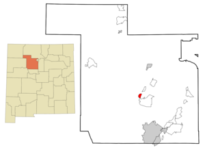
mapsize = 250px
map_caption = Location of San Ysidro, New Mexico
mapsize1 =
map_caption1 =subdivision_type = Country
subdivision_name =United States
subdivision_type1 = State
subdivision_name1 =New Mexico
subdivision_type2 = County
subdivision_name2 = Sandoval
government_footnotes =
government_type =
leader_title =
leader_name =
leader_title1 =
leader_name1 =
established_title =
established_date =unit_pref = Imperial
area_footnotes =area_magnitude =
area_total_km2 = 6.1
area_land_km2 = 6.1
area_water_km2 = 0.0
area_total_sq_mi = 2.3
area_land_sq_mi = 2.3
area_water_sq_mi = 0.0population_as_of = 2000
population_footnotes =
population_total = 238
population_density_km2 = 39.3
population_density_sq_mi = 101.8timezone = Mountain (MST)
utc_offset = -7
timezone_DST = MDT
utc_offset_DST = -6
elevation_footnotes =
elevation_m = 1666
elevation_ft = 5466
latd = 35 |latm = 33 |lats = 12 |latNS = N
longd = 106 |longm = 46 |longs = 14 |longEW = Wpostal_code_type =
ZIP code
postal_code = 87053
area_code = 505
blank_name = FIPS code
blank_info = 35-71020
blank1_name = GNIS feature ID
blank1_info = 0928807
website =
footnotes =San Ysidro is a village in Sandoval County,
New Mexico ,United States . The population was 238 at the 2000 census. It is part of the Albuquerque Metropolitan Statistical Area.The village is near the junction of
U.S. Highway 550 and NM Highway 4, at the south end of the Jemez Valley. The Jemez River runs through San Ysidro, just north of where the Rio Salado River joins the Jemez River.The village has been a farming community since 1699 when Juan Trujillo established a settlement named for San Ysidro, or Saint Isidore the Farmer. The Village was incorporated in 1967. An annual San Ysidro Fiesta Day is held each year in mid-May.
Geography
San Ysidro is located at coor dms|35|33|12|N|106|46|14|W|city (35.553457, -106.770566)GR|1.
According to the
United States Census Bureau , the village has a total area of 2.3square mile s (6.1km² ), all of it land.Demographics
As of the
census GR|2 of 2000, there were 238 people, 86 households, and 63 families residing in the village. Thepopulation density was 101.8 people per square mile (39.3/km²). There were 99 housing units at an average density of 42.3/sq mi (16.3/km²). The racial makeup of the village was 30.67% White, 0.84% African American, 7.56% Native American, 53.78% from other races, and 7.14% from two or more races. Hispanic or Latino of any race were 71.85% of the population.There were 86 households out of which 33.7% had children under the age of 18 living with them, 44.2% were married couples living together, 24.4% had a female householder with no husband present, and 25.6% were non-families. 22.1% of all households were made up of individuals and 4.7% had someone living alone who was 65 years of age or older. The average household size was 2.77 and the average family size was 3.16.
In the village the population was spread out with 29.0% under the age of 18, 9.7% from 18 to 24, 24.4% from 25 to 44, 23.5% from 45 to 64, and 13.4% who were 65 years of age or older. The median age was 36 years. For every 100 females there were 84.5 males. For every 100 females age 18 and over, there were 83.7 males.
The median income for a household in the village was $30,521, and the median income for a family was $32,188. Males had a median income of $26,429 versus $16,442 for females. The
per capita income for the village was $14,787. About 10.6% of families and 15.1% of the population were below thepoverty line , including 17.6% of those under the age of eighteen and 7.7% of those sixty five or over.References
External links
* [http://www.mrcog-nm.gov/village_of_san_ysidro.htm Village of San Ysidro @ Mid Region Council of Governments - New Mexico]
Wikimedia Foundation. 2010.