- Meta, Missouri
-
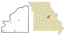
Meta, Missouri — City — Location of Meta, Missouri Coordinates: 38°18′45″N 92°10′5″W / 38.3125°N 92.16806°WCoordinates: 38°18′45″N 92°10′5″W / 38.3125°N 92.16806°W Country United States State Missouri County Osage Area – Total 0.3 sq mi (0.9 km2) – Land 0.3 sq mi (0.9 km2) – Water 0.0 sq mi (0.0 km2) Elevation 646 ft (197 m) Population (2000) – Total 249 – Density 742.7/sq mi (286.8/km2) Time zone Central (CST) (UTC-6) – Summer (DST) CDT (UTC-5) ZIP code 65058 Area code(s) 573 FIPS code 29-47594[1] GNIS feature ID 0722248[2] Meta is a city in Osage County, Missouri, United States. The population was 249 at the 2000 census. It is part of the Jefferson City, Missouri Metropolitan Statistical Area and is also the world headquarters of Diamond Pet Foods.
Contents
Geography
Meta is located at 38°18′45″N 92°10′5″W / 38.3125°N 92.16806°W (38.312471, -92.167999)[3].
According to the United States Census Bureau, the city has a total area of 0.3 square miles (0.9 km²), all of it land.
Demographics
As of the census[1] of 2000, there were 249 people, 106 households, and 59 families residing in the city. The population density was 742.7 people per square mile (282.8/km²). There were 130 housing units at an average density of 387.8 per square mile (147.6/km²). The racial makeup of the city was 97.99% White, 1.20% Native American, and 0.80% from two or more races. Hispanic or Latino of any race were 1.20% of the population.
There were 106 households out of which 30.2% had children under the age of 18 living with them, 50.9% were married couples living together, 3.8% had a female householder with no husband present, and 43.4% were non-families. 41.5% of all households were made up of individuals and 25.5% had someone living alone who was 65 years of age or older. The average household size was 2.35 and the average family size was 3.32.
In the city the population was spread out with 27.7% under the age of 18, 6.8% from 18 to 24, 30.1% from 25 to 44, 17.3% from 45 to 64, and 18.1% who were 65 years of age or older. The median age was 37 years. For every 100 females there were 102.4 males. For every 100 females age 18 and over, there were 100.0 males.
The median income for a household in the city was $35,208, and the median income for a family was $43,750. Males had a median income of $26,875 versus $24,063 for females. The per capita income for the city was $13,902. About 9.1% of families and 16.7% of the population were below the poverty line, including 25.7% of those under the age of eighteen and 9.3% of those sixty five or over.
History
The Following information is about the town of Babbtown and what effect the Rock Island Railroad Rock Island Railroad had on the town of Meta.
This area of Osage county was settled by German Lutherans in the 1860s, and a small country church called St. John's Lutheran Church at Babbtown was founded in 1871. The congregation still meets in the original building that was constructed in 1873. When termites were discovered in the hewn log sills in the 1990s, congregation members rebuilt the foundation by jacking up the walls section-by-section and cutting out and replacing the termite-riddled timbers and wall structure.
By the late 19th century the neighboring town of Babbtown had developed into a prominent town in the area, with a general store and post office across from the church, a blacksmith shop, and a Lutheran school, which was built in the late 1890s and held classes from 1900-1930. The old schoolhouse was expanded in the 1970s and again in the 1990s, and is now used as a parish house. Around 1900, however, the Rock Island Railroad was built through what is now the town of Meta, and as that town grew, Babbtown dwindled away. The town of Meta was named after Meta Rowan, wife of Nathan J. Rowan.
If you make it to the church grounds, be sure to check out the Babbtown Bible Garden, a garden of biblical-related plants in front of the parish house. The Bible Garden is still a work in progress; it hasn't quite recovered from the Bible gardener's three-year absence due to a tour in Germany with the US Army. This information was placed with permission of the congregation, and the neighbors know about it. Feel free to visit if they come out to talk to you!
References
- ^ a b "American FactFinder". United States Census Bureau. http://factfinder.census.gov. Retrieved 2008-01-31.
- ^ "US Board on Geographic Names". United States Geological Survey. 2007-10-25. http://geonames.usgs.gov. Retrieved 2008-01-31.
- ^ "US Gazetteer files: 2010, 2000, and 1990". United States Census Bureau. 2011-02-12. http://www.census.gov/geo/www/gazetteer/gazette.html. Retrieved 2011-04-23.
External links
- Historic maps of Meta in the Sanborn Maps of Missouri Collection at the University of Missouri
Municipalities and communities of Osage County, Missouri Cities Belle‡ | Bland‡ | Chamois | Linn | Meta | Westphalia
Villages Townships Benton | Crawford | Jackson | Jefferson | Linn | Washington
Unincorporated
communitiesFootnotes ‡This populated place also has portions in an adjacent county or counties
Categories:- Cities in Osage County, Missouri
- Jefferson City metropolitan area
Wikimedia Foundation. 2010.


