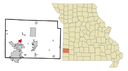
- Oronogo, Missouri
-
Oronogo, Missouri — City — Location of Oronogo, Missouri Coordinates: 37°11′25″N 94°28′2″W / 37.19028°N 94.46722°WCoordinates: 37°11′25″N 94°28′2″W / 37.19028°N 94.46722°W Country United States State Missouri County Jasper Area – Total 2.0 sq mi (5.3 km2) – Land 2.0 sq mi (5.2 km2) – Water 0.0 sq mi (0.1 km2) Elevation 919 ft (280 m) Population (2010) – Total 2,381 – Density 484.1/sq mi (186.9/km2) Time zone Central (CST) (UTC-6) – Summer (DST) CDT (UTC-5) ZIP code 64855 Area code(s) 417 FIPS code 29-54920[1] GNIS feature ID 0729941[2] Oronogo is a city in Jasper County, Missouri, United States. The population was 2,381 at the 2010 census. It is part of the Joplin, Missouri Metropolitan Statistical Area.
Contents
Name
The name, according to local tradition, came about when it was found that the previous name, "Minersville" was already taken. At a public meeting to change the name, after considering many possibilities, a man in the back blurted out "its Ore or no go", referring to the mining operations. Elaborating on that, Colonel J. M. Young, suggested substituting the Spanish word "Oro" for ore, and the dropping the "or" to make the word euphonius. He pronounced it "Oronogo" and the audience accepted the name.[3]
Geography
Oronogo is located at 37°11′25″N 94°28′2″W / 37.19028°N 94.46722°W (37.190202, -94.467289).[4]
According to the United States Census Bureau, the city has a total area of 2.0 square miles (5.2 km2), of which, 2.0 square miles (5.2 km2) of it is land and 0.04 square miles (0.10 km2) of it (1.47%) is water.
Demographics
Historical populations Census Pop. %± 1880 700 — 1900 2,073 — 1910 1,912 −7.8% 1920 981 −48.7% 1930 551 −43.8% 1940 593 7.6% 1950 519 −12.5% 1960 513 −1.2% 1970 492 −4.1% 1980 525 6.7% 1990 595 13.3% 2000 976 64.0% 2010 2,381 144.0% U.S. Decennial Census As of the census[1] of 2000, there were 976 people, 350 households, and 263 families residing in the city. The population density was 484.1 people per square mile (186.6/km²). There were 403 housing units at an average density of 199.9 per square mile (77.0/km²). The racial makeup of the city was 93.65% White, 2.05% Native American, 0.10% Asian, 0.92% from other races, and 3.28% from two or more races. Hispanic or Latino of any race were 1.74% of the population.
There were 350 households out of which 40.9% had children under the age of 18 living with them, 63.4% were married couples living together, 9.1% had a female householder with no husband present, and 24.6% were non-families. 22.3% of all households were made up of individuals and 7.1% had someone living alone who was 65 years of age or older. The average household size was 2.79 and the average family size was 3.25.
In the city the population was spread out with 32.0% under the age of 18, 8.0% from 18 to 24, 30.7% from 25 to 44, 20.5% from 45 to 64, and 8.8% who were 65 years of age or older. The median age was 31 years. For every 100 females there were 89.9 males. For every 100 females age 18 and over, there were 90.3 males.
The median income for a household in the city was $33,839, and the median income for a family was $36,339. Males had a median income of $27,250 versus $19,000 for females. The per capita income for the city was $11,626. About 15.5% of families and 19.4% of the population were below the poverty line, including 27.6% of those under age 18 and 24.4% of those age 65 or over.
References
- ^ a b "American FactFinder". United States Census Bureau. http://factfinder.census.gov. Retrieved 2008-01-31.
- ^ "US Board on Geographic Names". United States Geological Survey. 2007-10-25. http://geonames.usgs.gov. Retrieved 2008-01-31.
- ^ Names of Places in Jasper County, Missouri
- ^ "US Gazetteer files: 2010, 2000, and 1990". United States Census Bureau. 2011-02-12. http://www.census.gov/geo/www/gazetteer/gazette.html. Retrieved 2011-04-23.
Municipalities and communities of Jasper County, Missouri Cities Alba | Asbury | Carl Junction | Carterville | Carthage | Duenweg | Jasper | Joplin‡ | La Russell | Neck City | Oronogo | Purcell | Reeds | Sarcoxie | Waco | Webb City
Villages Airport Drive | Avilla | Brooklyn Heights | Carytown | Duquesne | Fidelity
Unincorporated
communitiesDudenville‡ | Kendricktown | Maxville | Scotland
Footnotes ‡This populated place also has portions in an adjacent county or counties
Categories:- Cities in Jasper County, Missouri
- Joplin metropolitan area
Wikimedia Foundation. 2010.


