- California State Route 18
Infobox road
state=CA
type=SR
route=18
section=318
maint=Caltrans 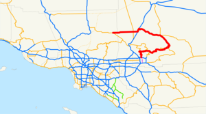
length_mi=117.21
length_ref= [http://www.dot.ca.gov/hq/structur/strmaint/brlog2.htm January 1, 2006 California Log of Bridges on State Highways] ]
length_round=2
established=1934 [http://cahighways.org/017-024.html#018 California Highways: State Route 18] ]
direction_a=South
terminus_a=jct|state=CA|SR|210 in San Bernardino
junction=jct|state=CA|SR|138 near Crestline
jct|state=CA|SR|38 at Big Bear City
jct|state=CA|I|15 in Victorville
direction_b=North
terminus_b=jct|state=CA|SR|138 near Pearblossom
previous_type=SR
previous_route=17
next_type=SR
next_route=19State Route 18 in the
U.S. state ofCalifornia runs from State Route 210 in San Bernardino to State Route 138 near Adelanto. It is the primary route into theSan Bernardino Mountains and has two discontinunities: one in Big Bear Lake, the other in Victorville. This route is part of theCalifornia Freeway and Expressway System [http://www.leginfo.ca.gov/cgi-bin/displaycode?section=shc&group=00001-01000&file=250-257 CA Codes (shc:250-257)] ] and is eligible for the State Scenic Highway System [http://www.leginfo.ca.gov/cgi-bin/displaycode?section=shc&group=00001-01000&file=260-284 CA Codes (shc:260-284)] ] .Route description
The constructed portion of Route 18 begins at State Route 210 (which as of January 2008 is signed as State Route 30) and quickly enters the San Bernardino Mountains as a four-lane
expressway . Hwy 18 is known as Waterman Ave. in the city of San Bernardino before turning into Highway 18. The route climbs north at a gentle grade until it turnseast , where it begins to offer panoramic views of San Bernardino and the Inland Empire. Hence, this portion of Route 18 is known as the Rim of the World Highway. After meeting State Route 138 at Crestline, the expressway reverts to a two-lane mountain road. It meets two other highways, State Route 189 just east of Arrowhead Highlands and State Route 173 in Lake Arrowhead, before running over State Route 330 in Running Springs. Route 18 continues through several valleys and nearski resorts before reaching a summit. At that point, Route 18 again runs along a lengthy mountain ridge, offering more spectacular scenery at an even higherelevation . At its west junction with State Route 38 near the west corner ofBig Bear Lake , Route 18 jogs across adam and travels along the south shore of Big Bear Lake. After going through the City of Big Bear Lake, it overlaps with Route 38 (considered the first discontinuity since Big Bear Blvd. has no clear signage of where 18 turns off) and moves from the south to the north side of Bear Valley east of both Big Bear Lake and the Big Bear City airport before it descends from the mountains to the desert on the northerly side of the mountains, first heading northeast, briefly north, and then northwest.Route 18 at this point follows the cities on the north face of the San Bernardino Mountains in the Mojave Desert: In Lucerne Valley, it intersects State Route 247 and then turns west for 21 miles (junctioning with major cutoff Bear Valley Road). It becomes an expressway (Happy Trails Highway, given for the High Desert's residency and final resting place of the 1950's singing cowboy, Roy Rogers) through Apple Valley and Victorville. It joins with Interstate 15 inside of Victorville (this is considered a discontinuity, since the freeway entries refer to I-15 only and not State Route 18, which has partial route markings along the freeway, mainly on Southbound I-15) for a few miles to the southeast and south before taking off west across the desert, reducing into a two-lane highway again outside of Victorville and meeting U.S. Route 395 in Adelanto, crosses into Los Angeles County as the beginning of county-named Pearblossom Highway and ending at State Route 138 east of Llano.
Route 18 thus takes an unusual path in the shape of a
question mark . On most of the signs of the highway, cardinal descriptions are not posted below the route markers, since it does not clearly go either west/east or north/south.History
Much of SR 18 has been signed since 1917, with the portion north of Big Bear Lake dating from 1933. Since 1963, State Route 18 has generally been legislatively defined as from Interstate 10 to State Route 138 going through San Bernardino through
Waterman Canyon and nearBig Bear Lake and Victorville. However, the section from Interstate 10 to present-day State Route 210 never was built, although it was designated as Legislative Route 26 in1916 and Legislative Route 275 in 1959. In 1964, SR 18 was rerouted from the northern side ofBig Bear Lake to the southern side along the former routing of SR 30 and lost its Legislative Route 43 designation. In 1984, the portion of SR 18 running concurrently with Interstate 15 in Victorville was removed from the legislative definition. In 1991, SR 18 was rerouted to Lakeview Drive and out of the downtown area of Big Bear Lake city proper, and this is now a business route of SR 18.Before 1956, SR 18 continued south of San Bernardino to Lakewood, routed on what is now Interstate 215 and State Route 91 as well as Lakewood Boulevard. SR 18 then ran concurrently with State Route 19 to the western terminus of U.S. Route 6 in Long Beach.
Major intersections
:"Note: Except where prefixed with a letter,
postmile s were measured in 1964, based on the alignment as it existed at that time, and do not necessarily reflect current mileage. The numbers reset at county lines; the start and end postmiles in each county are given in the county column."References
External links
* [http://www.westcoastroads.com/california/ca-018.html California @ WestCoastRoads - State Route 18]
* [http://www.dot.ca.gov/hq/roadinfo/sr18 Caltrans: Route 18 highway conditions]
* [http://www.threepineslodge.com/big-bear-lake-weather.php#live_cams Route 18 Live Web Cam in Big Bear Lake's Boulder Bay]
* [http://www.cahighways.org/017-024.html#018 California Highways: Route 18]

Wikimedia Foundation. 2010.