- Mission Peak
-
Mission Peak 
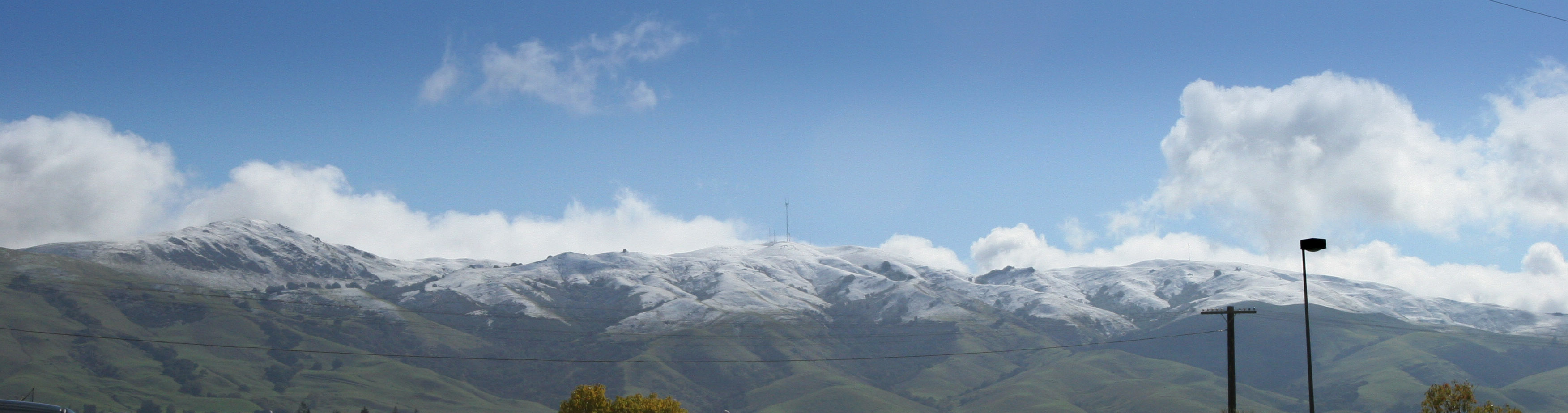
Elevation 2,517 ft (767 m) [1] Location Location Alameda County, California, USA Range California Coast Range Coordinates 37°30′45″N 121°52′50″W / 37.5124365°N 121.8805126°WCoordinates: 37°30′45″N 121°52′50″W / 37.5124365°N 121.8805126°W[2] Topo map USGS Niles Climbing Easiest route Hike Mission Peak is a peak east of Fremont, California. It is part of a ridge that includes Mount Allison and Monument Peak. Mission Peak is located in the Mission Peak Regional Preserve and is a part of the East Bay Regional Park District. There is regular snowfall every winter, but it is typically light and melts relatively quickly. Once or twice a decade, there is tremendous snowfall, such as in March 2006 (visible in the Hiking section). On December 7, 2009, there was an even deeper snowfall dropping to 1,000 feet. The snow lasted three days.[3]
Contents
Geology
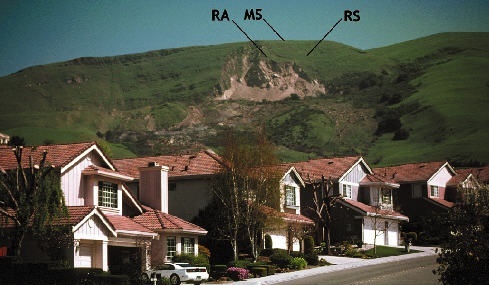
 Landslide on the side of Mission Peak
Mission Peak is the site of a large (300 m wide by 1200 m long) landslide that started in March, 1998 due to the El Niño rains that winter. The landslide occurred in an area that had seen previous landslides in the past.[4] The landslide threatened new housing and has changed local development regulations to deal with geotechnical hazards.[5]
Some sources have labeled Mission Peak as an extinct volcano due to its shape and the sharp point of the peak. This, however, is simply the result of natural uplift and erosion though; the peak has no volcanic origin. This range of the hills is being compressed due to the proximity of the Hayward Fault to the west and the Calaveras Fault to the east, which has led to a number of smaller faults and uplift.[4]
Environment
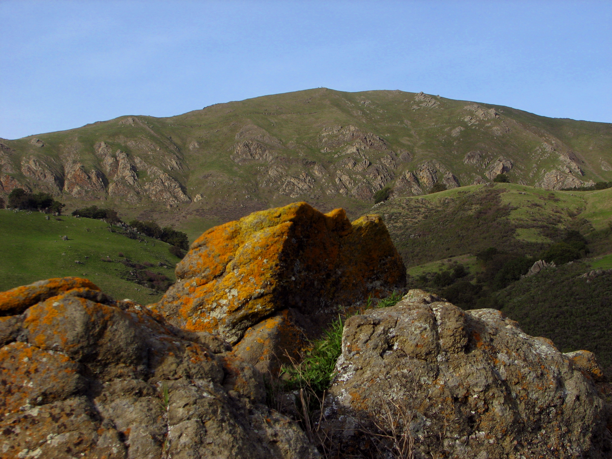
Mission Peak is home to California oak woodland and chaparral. Typical of the interior Coast Ranges, the woodland is mixed, made of Coast Live Oak, California Bay, California Buckeye, Blue Oak, and Western Sycamores. Black Oak is rare and scattered around the peak. Most stands have been logged. There are also some Bigleaf Maples. Gray Pines exist in mixed stands of oaks and isolated lone stands on the high slopes. The best example is the old-growth oak forest in the Hidden Valley (see Hiking) known as A.A. Moore Memorial Grove, which contains all the tree species. Many of the oaks are three hundred to six hundred years old. Sadly, many oaks are over a hundred years old, while almost none are younger than fifty. The saplings have been shorn by cattle and choked by invasives since 1797. The steepest slopes are home to hard, evergreen chaparral. This also has a confusing mixture, primarily California Sagebrush, Chamise, and Scrub Oak but many others. Blue oak often grows among the chaparral. The grasslands are a mix of native and nonnative grasses brought along by cows, though many native wildflowers grow in the spring. Mission Peak's cattle have a reputation to be feisty. There are many black-tailed deer. Pronghorn were extirpated in the late 19th century and so were Tule Elk. Tule Elk were reintroduced to Alameda County and are occasional visitors. Predators include bobcats, coyotes, gray foxes, and mountain lions which are very rarely seen. Small mammals include the Black-tailed Jackrabbit, the Western Gray Squirrel, and California Ground Squirrels. Visitors should be advised that Northern Pacific rattlesnakes are very common. Southern Alameda county has the high density of nesting Golden Eagles, thus, they can be seen often, along with Turkey Vultures, Red-tailed Hawks, Red-shouldered Hawks, Prairie Falcons, and Sharp-shinned Hawks. They also nest here, usually in steep valleys on the slopes, where no trails enter.[6] There is a herd of feral goats on the peak.[7][8]
Hiking
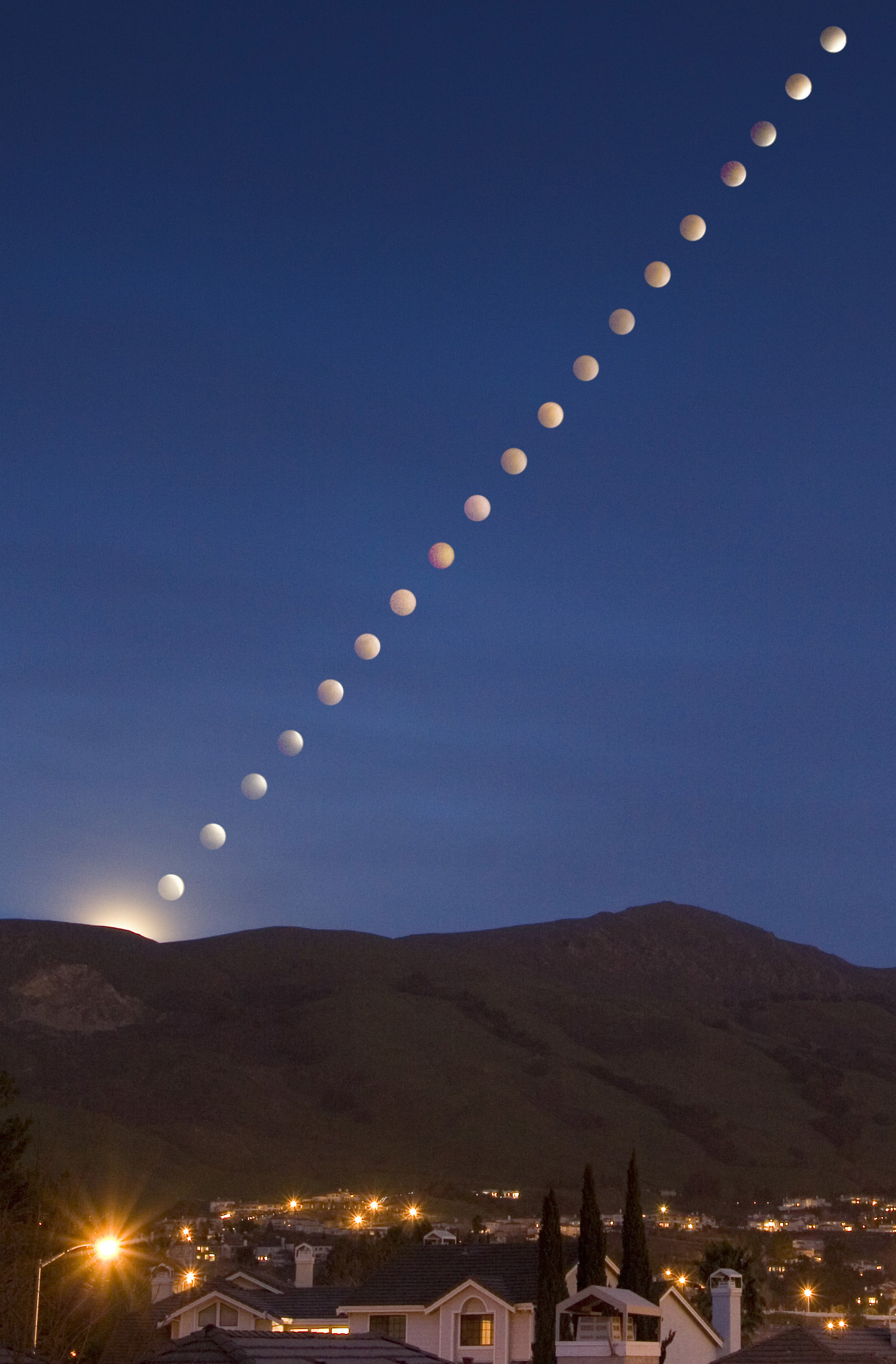
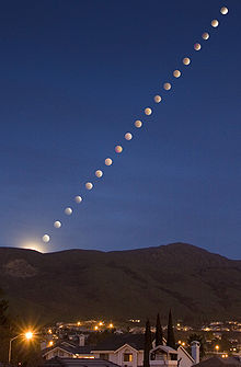 A rare lunar eclipse (shown in time lapse composite) rises over Mission Peak in Feb. 2008
Mission Peak is served by three trails from its western face. The Peak Trail starts at Ohlone College and heads southwards to the summit. While this trail is generally the least steep of the three, it is still quite challenging for casual hikers and requires considerable endurance due to a steady 4 mile uphill hike and 2100 feet elevation change. The other two trails, the Hidden Valley and Peak Meadow Trails both begin their ascent from Stanford Avenue and ascend the western face. They offer regular panoramic views of the Bay Area, however they are considerably steeper than the Peak Trail.[9] Parking is available at both locations, although there is a charge for parking at the campus parking lot. The lot at the end of Stanford Avenue is free although space is limited (street parking is legal a few blocks further down). AC Transit buses are also an option, providing service to Ohlone College from BART.
There are two more approaches to Mission Peak. One is from Sunol Regional Wilderness. This route climbs 2200 feet over 5 miles along gentler grade than Hidden Valley Trail which climbs 2200' over just 3 miles. The other approach is from Ed R. Levin County Park in Milpitas. This route first climbs 2200 ft from the Park HQ to Monument Peak over 3 miles, and from there Mission Peak is another 3 miles to the north along a mostly flat trail. This 3 mile long route passes along Mount Allison, the tallest point among these three peaks on the route. Mount Allison, which is about 170' higher than Mission Peak, is not open to public access but the trail passes very close to it. Mission Peak stands at 2,517 ft and Monument Peak is at 2594'.
Services along each trail are minimal to non-existent and shade from trees diminishes at higher altitude so hikers are cautioned to bring adequate supplies of water, sunscreen, and protective clothing. Sturdy hiking shoes are recommended as well although no climbing gear or technical climbing skill is required. It can be very windy and cold on top of the ridge regardless of season or weather conditions due to the peak's exposed position. Still, it's best to keep the carried weight to a minimum. Even a few extra pounds can become tiring on a steady uphill hike like this one.
Views from the peak vary with weather conditions, but it is common to be able to see the other high peaks of the Bay Area, including Mount Diablo, Mount Hamilton, and Mount Tamalpais. Furthermore, the peak provides good views of the cities of Oakland, San Jose, San Francisco, and Fremont. Under the right conditions (usually a crisp and clear winter day) even the Sierra Nevada range can be seen approximately 100 miles to the east.

Hiking on Mission Peak also has connections to and from a broader regional trail network. Mission Peak contains part of the Bay Area Ridge Trail (which is still under construction). This trail leads southwards along (and up) the ridge to Monument Peak and the Ed R. Levin County Park in the hills above Milpitas. Hikers can also access the Ohlone Wilderness trail that descends east from near the peak towards Sunol Regional Wilderness. This trail ultimately leads to Lake Del Valle south of Livermore, although this is a trek requiring usually at least two nights of camping as well as permits (available at Sunol Regional Park) allowing entrance to the deeper areas of the range. Also situated on the eastern side of the summit is the new Eagle Spring Backpack campsite.
Visitors to the park might also notice a group of buildings below the summit in a small valley, known as the Hidden Valley, on the western face of the mountain. These were formerly the Peak Meadow Ranch owned by the McClure Family, who ran cattle on Mission Peak for a number of decades in the 20th Century. They are now the residence of the park caretaker and are not open to the public.
References
- ^ "Mission Peak, California". Peakbagger.com. http://www.peakbagger.com/peak.aspx?pid=23507. Retrieved 2009-01-01.
- ^ "Mission Peak". Geographic Names Information System, U.S. Geological Survey. http://geonames.usgs.gov/pls/gnispublic/f?p=gnispq:3:::NO::P3_FID:228839. Retrieved 2009-01-04.
- ^ "Weather advisory after snow falls throughout Bay Area". San Francisco Chronicle. 7 December 2009. http://www.sfgate.com/cgi-bin/article.cgi?file=/baycitynews/archive/2009/12/07/weather07.DTL&tsp=1.
- ^ a b Rogers, J. D.; Drumm, P. L. (8 May 1999). "Overview of the 1998 Mission Peak Landslide, Fremont, California". Northern California Geological Society Field Trip Guide (Missouri University of Science and Technology): p. 15. http://web.mst.edu/~rogersda/hazard_mitigation_techniques/landslides/fremont/MP.htm#Site%20Conditions. Retrieved 2009-01-04.
- ^ "Mission Peak Landslide". City of Fremont. http://www.ci.fremont.ca.us/Environment/MissionPeakLandslide/Default.htm. Retrieved 2009-01-04.
- ^ "Avian Mortality". Golden Gate Audubon Society. http://www.goldengateaudubon.org/conservation/birds-at-risk/avian-mortality-at-altamont-pass/. Retrieved 2010-05-23.
- ^ "Mission Peak Regional Preserve". East bay Regional Park District. http://www.ebparks.org/parks/mission. Retrieved 2010-05-23.
- ^ "Peak Meadow Ranch History". Omega Foundation. http://www.omegafoundation.info/history. Retrieved 2010-05-17.
- ^ "East Bay Parks map of hiking trails". East bay Regional Park District. http://www.ebparks.org/files/EBRPD_files/brochure/mission_peak_map.pdf. Retrieved 2009-01-04.
External links
- "Mission Peak Photo gallery". www.JagatJoraJaal.com. http://www.jagatjorajaal.com/mission.html. Retrieved 2010-05-23.
- "Mission Peak Regional Preserve". East bay Regional Park District. http://www.ebparks.org/parks/mission. Retrieved 2010-05-23.
East Bay Regional Parks Parks Anthony Chabot · Briones · Castle Rock · Contra Loma · Coyote Hills · Crockett Hills · Del Valle · Diablo Foothills · Dry Creek Pioneer · Garin · Lake Chabot · Middle Harbor Shoreline · Pleasanton Ridge · Redwood · Ridgelands · Shadow Cliffs · Sobrante Ridge · Temescal · Tilden · Wildcat CanyonShorelines Preserves/Open Spaces Bishop Ranch · Black Diamond Mines · Brushy Peak · Claremont Canyon · Huckleberry · Leona Canyon · Mission Peak · Morgan Territory · Sibley · Round Valley · Sobrante Ridge · Sycamore Valley · Waterbird ·Wilderness Areas Recreation Areas Trails Other Categories:- East Bay Regional Park District
- Geography of Fremont, California
- Parks in Alameda County, California
- Mountains of the San Francisco Bay Area
- Mountains of Alameda County, California
Wikimedia Foundation. 2010.