- Delfzijl
-
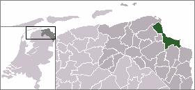
Delfzijl — Municipality — 
Flag
Coat of arms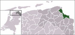
Coordinates: 53°20′N 6°55′E / 53.333°N 6.917°E Country Netherlands Province Groningen Area(2006) - Total 227.48 km2 (87.8 sq mi) - Land 132.47 km2 (51.1 sq mi) - Water 95.02 km2 (36.7 sq mi) Population (1 January, 2007) - Total 27,674 - Density 209/km2 (541.3/sq mi) Source: CBS, Statline. Time zone CET (UTC+1) - Summer (DST) CEST (UTC+2) Delfzijl (
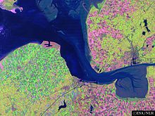
 pronunciation (help·info), Gronings: Delfsiel) is a municipality and city in the northeast of the Netherlands. It is situated on the left bank of the river Ems estuary, which forms the border with Germany.
Contents
Population centres
Bierum, Biessum, Borgsweer, Delfzijl, Farmsum, Godlinze, Holwierde, Krewerd, Losdorp, Meedhuizen, Spijk, Termunten, Termunterzijl, Uitwierde, Wagenborgen, Weiwerd, Woldendorp.
Transportation
Industry
Delfzijl is the fifth biggest seaport in the Netherlands and the home of an aluminium plant run by the company Aluminium Delfzijl (part of Corus Group). In 2004 the smelter produced a record 112,400 tonnes of liquid aluminium. The foundry produced 157,700 tonnes of raw product.
Delfzijl is also known for its chemical industry. On the edge of the town lies an industrial site with an area of 3 square kilometers which is one of the biggest employers in the area. This site is responsible for the second largest quantity of exported chemicals in the Netherlands (after Rotterdam), and is known for its major exports of chlorine and related products.
Events
Every five years the city organises Delfsail, the largest sailing event of The Netherlands.
Annually the "Pinksterfeesten" (Whitsunfestivities) are organised in the city. Delfzijl is seeing a strong resurge in the Dutch economy as the physical centerpoint of Energy Valley. This is the result of a strategic collaboration with the German town of Emden, on the other side of the Eems Estuary.
International relations
Main article: List of twin towns and sister cities in The NetherlandsTwin towns — sister cities
Delfzijl is twinned with:
- Aubenas (France)
- Cesenatico (Italy)
- Schwarzenbek (Germany)
- Sierre (Switzerland)
- Zelzate (Belgium)
- Shūnan (Japan)
See also
External links
Villages DelfzijlHamlets Bierum - Biessum - Borgsweer - Farmsum - Godlinze - Holwierde - Krewerd - Losdorp - Meedhuizen - Spijk - Termunten - Termunterzijl - Uitwierde - Wagenborgen - Weiwerd - WoldendorpList of cities, towns and villages in Groningen Appingedam · Bedum · Bellingwedde · Delfzijl · Eemsmond · Groningen · Grootegast · Haren · Hoogezand-Sappemeer · Leek · Loppersum · De Marne · Marum · Menterwolde · Oldambt · Pekela · Slochteren · Stadskanaal · Ten Boer · Veendam · Vlagtwedde · Winsum · Zuidhorn

See also: Netherlands · Provinces · Municipalities Coordinates: 53°20′N 6°55′E / 53.333°N 6.917°E
Categories:- Cities in the Netherlands
- Municipalities of Groningen (province)
- Populated places in Groningen (province)
- Port cities and towns in the Netherlands
- Port cities and towns of the North Sea
- Groningen geography stubs


Wikimedia Foundation. 2010.