- Weiwerd
Dutch town locator maps
mun_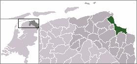
town_
caption = Weiwerd in the municipality of Delfzijl.Weiwerd (coord|53|19|N|6|57|E|type:city(100)) is a village in the Dutch province of Groningen. It is a part of the municipality of
Delfzijl , and lies about 27 km east of Groningen."ANWB Topografische Atlas Nederland", Topografische Dienst and ANWB, 2005.] Formerly a farming community with its own church, school, and shops, the whole village was scheduled for demolition in the 1970's to allow the industial area of Delfzijl harbour to be expand. Only about 20% of the orriginal buildings are left.References

Wikimedia Foundation. 2010.